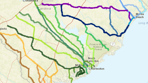
South Carolina Government South Carolina's evacuation routes.
Although South Carolina had not ordered a mandatory evacuation on September 7, the state does have very detailed evacuation route maps for major cities.
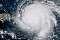
As Hurricane Irma shifts east in forecast models, imperiling South Carolina, authorities are urging people to get prepared, and it’s a good idea to know what the routes and zones are and where to find them. South Carolina’s governor has declared a state of emergency.
“Gov. Henry McMaster said he plans on issuing mandatory coastal evacuations starting at 10 a.m. Saturday along with a complete lane reversal of Interstate 26 from Charleston to Columbia as Hurricane Irma heads toward South Carolina,” The Post and Courier reported on September 7. “Lane reversals also will take place out of Myrtle Beach (U.S. 501), Beaufort (U.S. 21) and Hilton Head Island (U.S. 278) under evacuation orders.”
The governor ordered evacuations of hospitals and nursing homes in some counties:
NEW: Gov. McMaster ordered evacuation of hospitals/nursing homes in Colleton, Dorchester, Charleston, Berkeley Co. #IRMA
— Ashley Blackstone (@ashblackstone) September 7, 2017

That information is time specific, and it could always change. If they are ordered, evacuations would likely come on September 8, but that had not been determined.
“It is a precaution. It is not an order for evacuation. I repeat. This is not an order for mandatory evacuation,” the governor, Henry McMaster, said in a September 6 press conference that he called to declare the state of emergency. “This is a state of emergency…something is likely to happen, and we need to get prepared.”
The state of emergency allows emergency management officials “to begin execution of our state Hurricane preparedness plan on the state and local level. It also allows the National Guard to preposition resources and move people… in anticipation of evacuation, probably of the low country, and in anticipation of landfall of the hurricane,” he added.
The governor repeated: “I will say again. I am not ordering an evacuation at this time. But we will do that at the appropriate time when and if it gets here.”
Forecast models show Hurricane Irma “may pose a significant threat” to South Carolina, the governor’s state of emergency declaration for the State of South Carolina said.

You can find the full South Carolina evacuation route map here.
You can see the maps for other South Carolina cities here.
Here are the maps for some cities in South Carolina:
Charleston
Downtown Charleston
Myrtle Beach
Hilton Head
Sumter
Beaufort
Here is the text version of the South Carolina evacuation routes.
Here is the text version of the South Carolina evacuation routes.
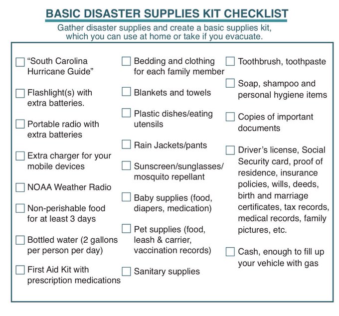
Authorities suggested that people stock up on supplies, like bottled water.
We recommend 2 gallons of water per person per day for at least 3 days. One gallon for drinking, one gallon for sanitary needs. #Irma
You can watch the South Carolina governor’s September 6 press conference here:
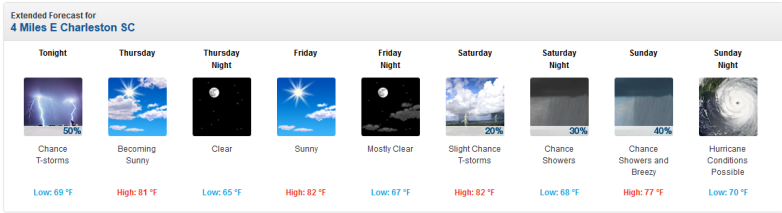
The latest Hurricane Irma forecast models for September 6 now show that South Carolina, including Charleston, might be in the path of the monster hurricane. Hurricane conditions are now listed as possible on Sunday by the National Weather Service forecast for Charleston.
National Weather Service
South Carolina is now in the forecast cone. That doesn’t meant the hurricane will strike it. The storm is unpredictable.
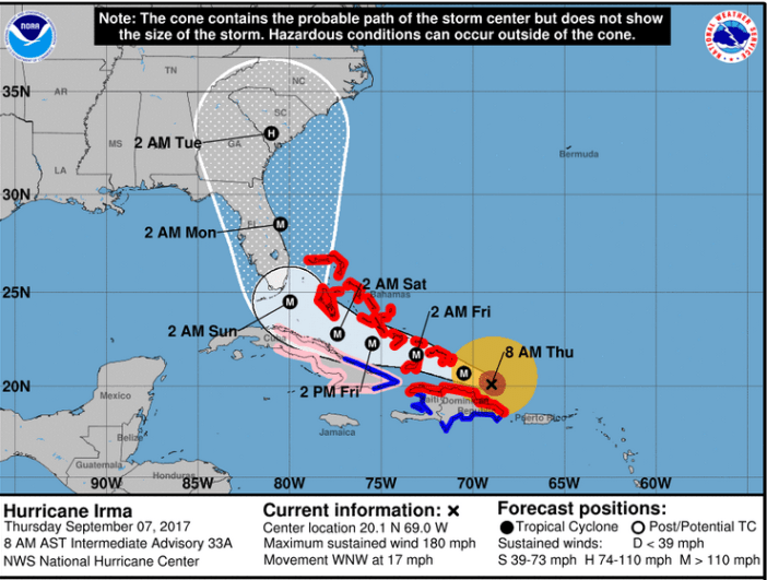
NWSThe Irma forecast cone as of the morning of September 7.
Learn more about Charleston’s September 7 forecast here: