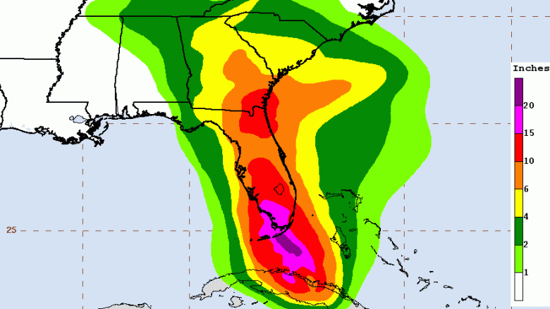
NOAA/NHC Hurricane Irma rainfall total estimates from the National Hurricane Service.
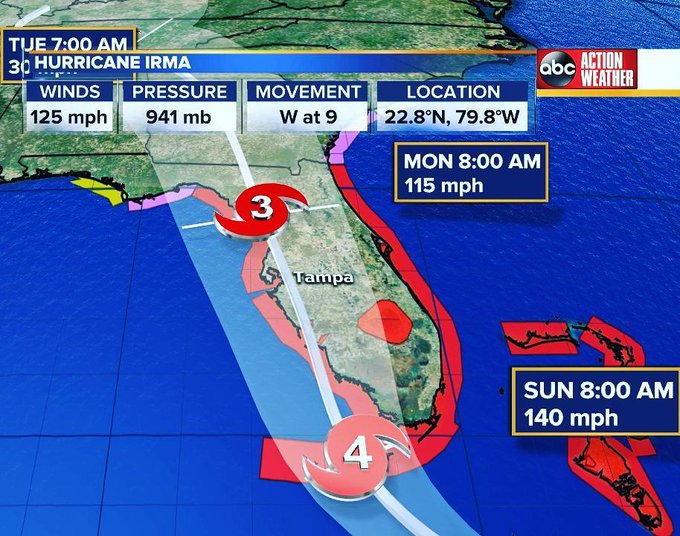
Sarasota and the rest of Sarasota County are expected to take a major hit from Hurricane Irma by Sunday afternoon, according to the latest public advisory from the National Hurricane Center. However, the city will feel the effects of the storm before then. The area is under a Hurricane Warning and Storm Surge Warning.
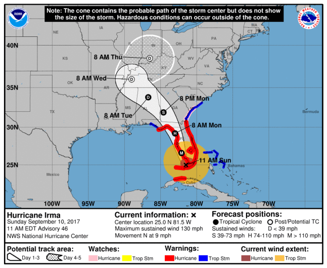
NOAA/NHCThe National Hurricane Center’s 11:00 a.m. ET Hurricane Irma projection.
The National Weather Service forecasts that Sarasota will begin experiencing thunderstorms and rain today into Saturday night. By Sunday, the city will experience tropical storm conditions, with hurricane conditions arriving by Sunday night. Sarasota could continue to see rain and thunderstorms into Thursday.
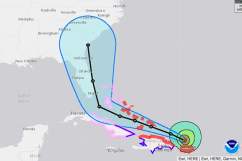
Hurricane center forecast continues to indicate major #HurricaneIrma impacts to #Florida west coast. #flwx t.co/6qwcNhxpf6
The 2:00 p.m. ET advisory notes that Irma has been downgraded to a Category 3 hurricane, with sustained winds at 120 mph. It re-gained strength over the Florida Strait after passing over Cuba. Hurricane force winds extending outward from the storm have already reached up to 80 mph.
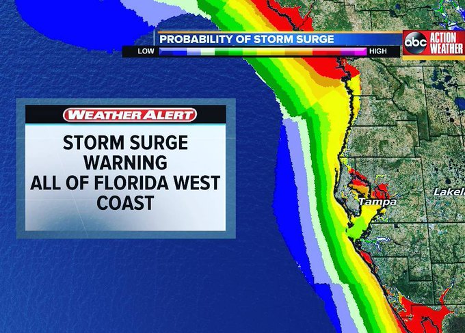
Storm surge warnings extended for all of the west coast of #Florida head of #HurricaneIrma. t.co/ZqlEgQ4qCT
“Hurricane-force winds extend outward up to 80 miles (130 km) from the center and tropical-storm-force winds extend outward up to 220 miles (350 km),” the 2 p.m. advisory reads. “A 62 mph (100 km/h) sustained wind and 99 mph (158 km/h) gust was recently reported at the Federal Aviation Administration station at Miami International Airport. An 81 mph (130 km/h) wind gust was recently reported at the Miami Weather Forecast Office/National Hurricane Center.”
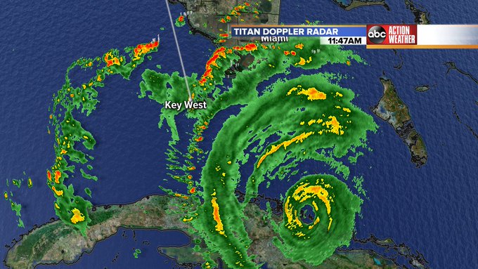
The eye of #hurricaneirma visible SE of Key West on Titan Doppler Radar. #flwx #GMTB #Irma
Storm surges around the west coast of Florida could reach up to 8 feet over normal levels. Cape Sable in Monroe County, the southernmost point of the mainland U.S., could see storm surges up to 10 to 15 feet.
Here is the seven-day forecast for Sarasota, from the National Weather Service. The NWS notes that the city is also under a flash flood watch.
Today: Tropical storm conditions, with hurricane conditions possible. Showers and possibly a thunderstorm.
Tonight: Hurricane conditions expected. Showers and possibly a thunderstorm. Temperature rising to around 83 by 1am. Chance of precipitation is 100%. New rainfall amounts in excess of 4 inches possible.
Monday: Tropical storm conditions expected, with hurricane conditions possible. Showers and possibly a thunderstorm, mainly before 2pm, then scattered showers and thunderstorms after 2pm. High near 85. Chance of precipitation is 80%. New rainfall amounts between a quarter and half of an inch possible.
Monday Night: Scattered showers and thunderstorms, mainly before 8pm. Mostly cloudy, with a low around 78. Breezy, with a southwest wind 13 to 18 mph, with gusts as high as 25 mph. Chance of precipitation is 30%.
Tuesday: Mostly sunny, with a high near 88. Southwest wind 9 to 11 mph.
Tuesday Night: Partly cloudy, with a low around 77. South southwest wind 5 to 7 mph.
Wednesday: Scattered showers and thunderstorms. Mostly sunny, with a high near 88. South southwest wind 5 to 8 mph. Chance of precipitation is 30%.
Wednesday Night: Scattered showers and thunderstorms. Mostly cloudy, with a low around 77. South southwest wind 3 to 7 mph. Chance of precipitation is 30%.
Thursday: Scattered showers and thunderstorms. Mostly cloudy, with a high near 88. South wind around 6 mph. Chance of precipitation is 50%.
Thursday Night: Scattered showers and thunderstorms. Mostly cloudy, with a low around 77. Chance of precipitation is 30%.
Friday: Scattered showers and thunderstorms. Mostly cloudy, with a high near 88. Chance of precipitation is 50%.
Friday Night: Isolated showers and thunderstorms. Mostly cloudy, with a low around 77. Chance of precipitation is 20%.
Saturday: Scattered showers and thunderstorms. Mostly sunny, with a high near 88. Chance of precipitation is 30%.
To find shelters in Sarasota, click here to use the FloridaDisaster.org site and type in your address. You can use this map to find your evacuation zone by typing in your address. Mandatory evacuations have been ordered for residents in Zone A, which includes those in low-lying areas, residents on the barrier islands and residents in mobile homes.