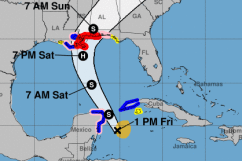
NOAA/NHC Tropical Storm Nate's path as of 1:00 p.m. CDT.
Tropical Storm Nate is expected to become at least a category 1 hurricane by the time it reaches the Gulf Coast, including Mobile, Alabama. Governor Kay Ivey has already issued a statewide State of Emergency to prepare for the storm. The National Hurricane Center also reports that a hurricane warning is already in effect for Alabama’s Gulf Coast. Here’s the latest forecast for Mobile.
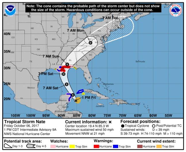
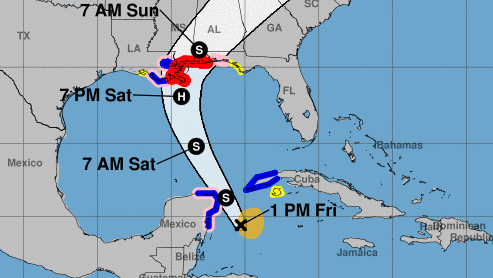
NOAA/NHCTropical Storm Nate forecast as of 1:00 p.m. CDT.
The 1:00 p.m. CDT forecast from the National Hurricane Center has Nate becoming at least a category 1 hurricane by the time it reaches the Louisiana coast. A category 1 hurricane has maximum sustained winds between 74 mph and 95 mph.
As of Friday afternoon, the storm has maximum sustained winds at 50 mph and the storm is about 125 miles east-southeast of Cozumel, Mexico. It is moving very quickly at 21 mph and is forecast to reach the Gulf Coast by late Saturday.
A Hurricane Watch is in effect for “East of the Alabama/Florida border to the Okaloosa/Walton County
Line” and a Hurricane Warning is in effect for “Grand Isle Louisiana to the Alabama/Florida border.”

“A Hurricane Warning means that hurricane conditions are expected somewhere within the warning area,” the NHC notes . “A warning is typically issued 36 hours before the anticipated first occurrence of tropical-storm-force winds, conditions that make outside preparations difficult or dangerous. Preparations to protect life and property should be rushed to completion.”
Governor Ivey issued a state of emergency earlier this week as the storm moved through Central America. The state of emergency began at 7:00 a.m. today.
“I have signed the State of Emergency, because it frees up personnel and resources in case there is a need to respond to any storm related activity,” Ivey said in a statement. “State and local leaders are ready to respond if needed, but our people need to stay weather-aware and heed any directions given by local officials.”
AL.com reported on Thursday that the Alabama State Port Authority already stopped accepting loaded barges and told ships to finish unloading and loading by 6 p.m. today. Judith Adams, vice president for marketing for the Port Authority, told AL.com that the issue with Nate isn’t that its scale, but its speed. Nate isn’t expected to become a major storm like Harvey or Irma, but its speed created “really a compressed timeline” to get prepared.
Here’s the full seven-day forecast for Mobile from the National Weather Service:
Friday Afternoon: A 20 percent chance of showers and thunderstorms. Partly sunny, with a high near 86. East wind 10 to 15 mph.
Friday Night: A 30 percent chance of showers and thunderstorms, mainly after 1am. Mostly cloudy, with a low around 76. East wind around 10 mph.
Saturday: Showers and possibly a thunderstorm. High near 84. East wind around 10 mph. Chance of precipitation is 80%. New rainfall amounts between a quarter and half of an inch possible.
Saturday Night: Tropical storm conditions possible. Showers and possibly a thunderstorm. Low around 77. Chance of precipitation is 80%.
Sunday: Tropical storm conditions possible. Showers and possibly a thunderstorm. High near 81. Chance of precipitation is 80%.
Sunday Night: A 40 percent chance of showers and thunderstorms. Cloudy, with a low around 77. Southwest wind 10 to 15 mph, with gusts as high as 20 mph.
Monday: A 40 percent chance of showers and thunderstorms. Mostly cloudy, with a high near 85. South wind 5 to 10 mph.
Monday Night: A 20 percent chance of showers and thunderstorms. Mostly cloudy, with a low around 74. South wind around 5 mph.
Tuesday: A 20 percent chance of showers and thunderstorms. Partly sunny, with a high near 87. Calm wind becoming southwest around 5 mph in the afternoon.
Tuesday Night: A 20 percent chance of showers and thunderstorms. Mostly cloudy, with a low around 71.
Wednesday: A 20 percent chance of showers and thunderstorms. Partly sunny, with a high near 84.
Wednesday Night: Partly cloudy, with a low around 66.
Thursday: Sunny, with a high near 83.