Google Maps & YubaNet Pawnee Fire
The Pawnee Fire has grown to more than 8,000 acres and is threatening 600 structures, with more than 22 destroyed. Mandatory evacuations have already been issued for the fire, which officials are working hard to contain. Gov. Brown declared a state of emergency in Lake County because of the fire. Low humidity, erratic winds, and above normal temperatures are helping the fire grow, officials said. Read on for more details about the fire, including maps of its location and information about current evacuations and damage.
The fire was first reported the evening of June 23, and it’s grown ever since, according to CAL FIRE.
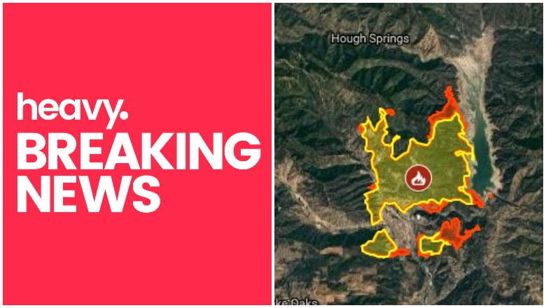
Maps of the Pawnee Fire
The fire is currently at 8,200 acres and is 0 percent contained. You can see a map of the fire above, from YubaNet.com and Google. The fire is located five miles northeast of Clearlake Oaks, California. Here’s another map of the fire below. The full PDF of the map can be accessed here.

While there was expansion of the #PawneeFire over night, the spread was slower. The Fire has now reached 8,200 acres. Firefighters have dug in and are working the blaze hard. Air attack operations will continue throughout the day today. The latest Fire map is below.

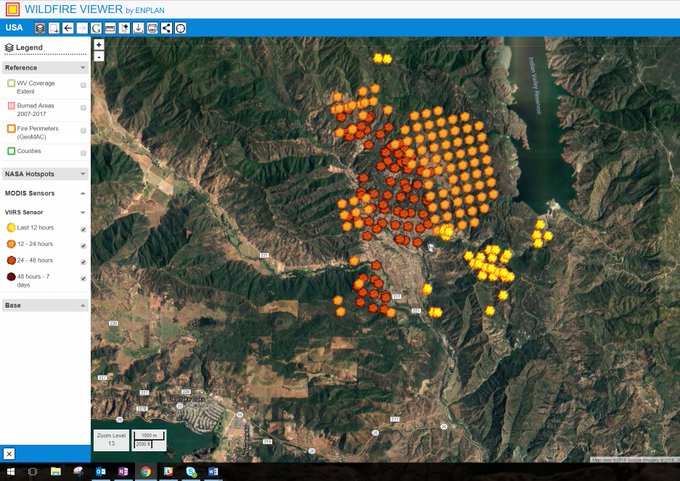
And another site for tracking the fire:
Track #PawneeFire breakout to the south.
NASA VIIRS and MODIS fire detections stream automatically and display progression. Developed by the ENPLAN geospatial team for positive, reliable wildfire tracking. Free access for 2 hours from time of posting: t.co/B2gft9pkTR
Mandatory Evacuations Were Ordered for Spring Valley
Mandatory evacuations were ordered for the entire Spring Valley community, CAL FIRE reported. This includes all roads off of Old Long Valley Road and New Long Valley Road, north of Highway 20. The evacuations also include Mule Skinner, Long Branch, Watertrough Rd, Flintlock, Muzzleloader, No Guns, Antelope, Cougar, Marianne, Ramrod, and Moccasin.
For the latest details and updates, visit the Lake County Sheriff’s Office website.
An evacuation center was set up at Lower Lake High School, and animal staging is located at the Social Service Center at 15975 Anderson Ranch Parkway in Lower Lake, California.
Road closures from the fire include New Long Valley Road at Highway 20 and Old Long Valley Road at Highway 20.
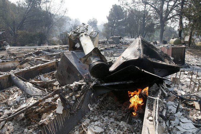
Here are photos and videos of the Pawnee Fire.
#Pawneefire rises with afternoon winds about two miles from the Spring Valleys Pantry in Clearlake Oaks. #ABC7now

#PawneeFire continues to burn Monday afternoon in Lake County.


#PawneeFire in Lake County in Lake County is burning fast today!

VIDEO: #PawneeFire continues to rage in Lake County. @JerryBrownGov has declared a state of emergency. Just spoke to a homeowner who is ready to jump on his Harley & evacuate if the flames 🔥 get too close #California
A firefighter from Twain Harte uses a Kestrel to monitor weather conditions. Wind & humidity are the biggest fire influencers right now. Winds blowing 9 mph, 94°, 18% humidity. The #PawneeFire is moving away from Spring Valley, but could change as afternoon winds pick up. @KPIXtv

This is a developing story.