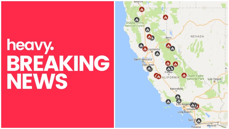
CAL FIRE & Google Maps California fires near me
Fires are still a problem in California, but quite a few that were previously issues are now under control. Here is a list, with maps, of the larger fires around the state, their current containment levels, and where they are located for July 14. Read on for more details. News is constantly changing, so call your local officials if you are concerned about evacuations near you.
General Map of California Fires
This map below is an interactive map of some of the bigger fires in California on July 14, provided by CAL FIRE and Google. Fires in red are active and fires in black are contained. Read the next section for details about the fires listed on the map.
The California Governor’s office has another active fire map for comparison, which is embedded below. This map periodically is made available only to those with a login, so if it’s not available when you’re reading this story, it might be released to the public again later.

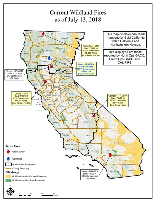
And here’s a map from July 13:
7/13 wildfire map of BLM-managed public lands. Follow fire info @inciweb → t.co/IDvGqBylED & @CAL_FIRE → t.co/F2s9h9A5Ld #DaleFire #CountyFire #KlamathonFire #ValleyFire #GeorgesFire #StoneyFire
List of Active Fires in California as of July 14
Here are the active fires and updates about them, per CAL FIRE. Most of these are in alphabetical order, but newer fires not yet listed on the CAL FIRE map may be included in a separate section at the end.
County Fire
#RT @CAL_FIRE: #CountyFire [update] east of Lake Berryessa (Yolo and Napa Counties) is now 90,288 acres and 97% contained. t.co/fJYDsptQMH
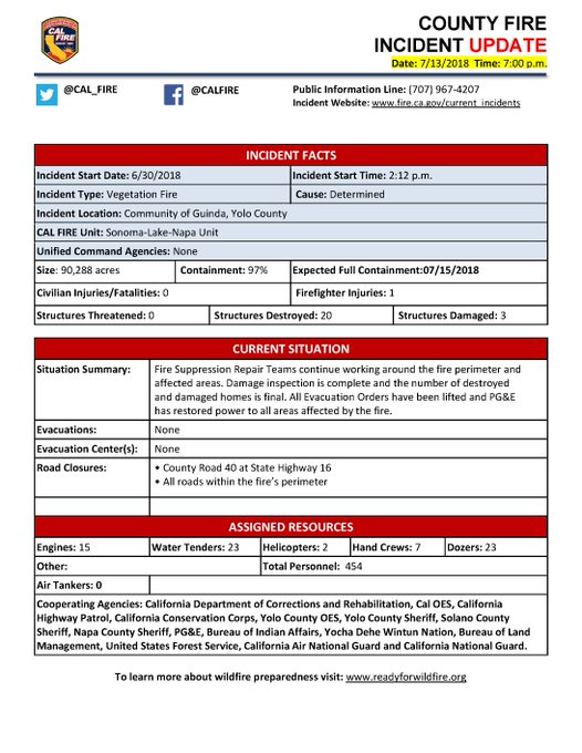
A fire in the rural community of Guinda in Yolo County is now 90,288 acres and 97 percent contained. Twenty structures were destroyed and all evacuations have been lifted, according to CAL FIRE. If you have questions about current evacuations and advisories in Yolo County, call 211. For questions regarding Napa County, text your ZIP code to 888777.
Dale Fire
This fire is no longer listed as active.
Eagle Fire
CAL FIRE is assisting the BLM Northern District (NOD) with a wildfire at County Rd 40/ County Rd1, southwest of Eagleville (Modoc County). #EagleFire
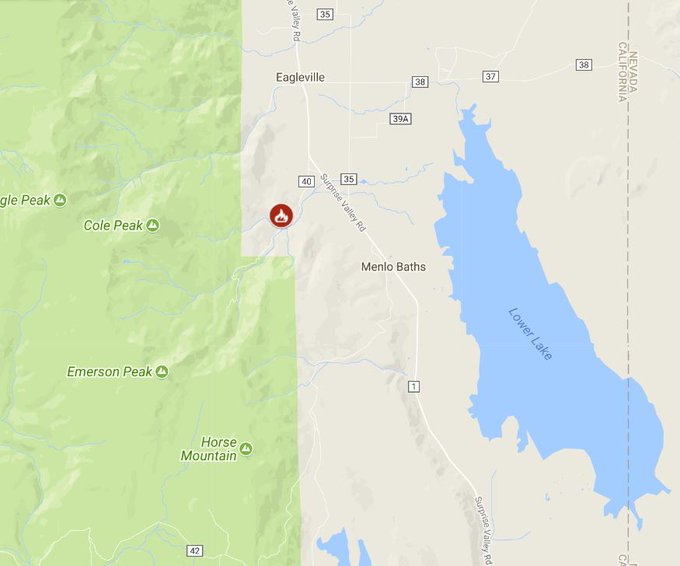
This fire is at County Road 40/County Road 1, southwest of Eagleville in Modoc County.
Ferguson Fire
This fire is off Highway 140 and Hite Cove, near El Portal in Mariposa County. It’s burning west of Yosemite National Park. It’s 130 acres and 5 percent contained. It began in the Merced River canyon near El Portal around 10:35 p.m. on Friday, Merced Sun Star reported.
#FergusonFire burning outside Yosemite National Park. Has potential.
#wildfire #CAFire t.co/2S8DS5mMzD
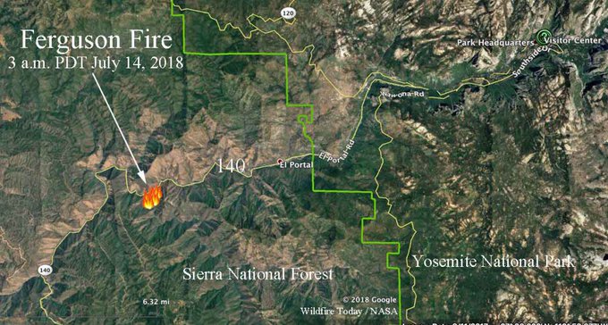
Another map of the Ferguson fire is below. More than 50 people have been evacuated, Merced Sun Star reported. This includes tourists near the Savage Trading Post, residents of a nearby home, and the Cedar Lodge and Red Bud Inn areas.
Highway 140 has been closed between mile marker 137 and Yosemite Lodge. Visitors can use Highway 41 and 120 to enter and leave the park, Merced Sun Star reported.
#FergusonFire causes evacuations, road closure just west of #Yosemite . Has grown to 130 acres, with 5 % containment
t.co/AUkQaO3kV9 #wildfire #CAfire

Georges Fire
This fire is off Hogack and Whitney Portal Road in Alabama Hills, Inyo County. It’s now 2,833 acres and 42 percent contained. See an interactive map of the fire above, courtesy of GMap4 and MappingSupport.com. This map will no longer be updated as of July 15 due to new rules from Google.
The #GeorgesFire remains at 2,883 acres and 42% contained. Crews continue suppression repair & patrol. Today, mgmt of the fire transitioned to a local Type 4 team, comprised of local firefighters from the Inyo NF.

Idria Fire
This fire is at Panoche Road and New Idrea Road, west of San Joaquin in San Benito County. It’s 116 acres and 85 percent contained.
James Loop Fire
This wildfire is at Jacks Valley Road and James Canyon Loop, seven miles northwest of Minden, Nevada. No other details are known at this time.
Klamathon Fire
This fire is off Klamathon Road and Copco Road, south of Hornbrook (Siskiyou County.) It is now 37,900 acres and 90 percent contained. The fire has remained a stable size, with increasing containment, over the last couple days. No additional fire spread is anticipated. According to Inciweb, all areas in Oregon will remain in a Level 1 (green) “Be Ready” status. Eighty-two structures were destroyed in this fire.
Lions Fire
This fire is located in the Sierra National Forest. It is now 4,064 acres with 90 percent containment. This fire was caused by lightning. According to InciWeb, there was no growth over the weekend. Inciweb hasn’t updated this since July 9, so it’s likely well contained at this point.
Panoche Fire
This fire is off Panoche Road, two miles north of the CAL FIRE Antelope Station, southeast of Hollister in San Benito County. It’s 278 acres and 95 percent contained.
Stoney Fire
@ChicoFD @CALFIRE_ButteCo @CAL_FIRE starting 3rd ops period with goal of increasing containment of #stoneyfire which is 55% contained and estimated to have burned 956 acres. Crews will work to extinguish hot spots and fortify fire lines. Send all media inquiries to @Chico_Chief
This fire is at Upper Park Road in Bidwell Park in Butte County. It’s 956 acres and 55 percent contained. According to CAL FIRE, evacuation orders have been lifted.
Valley Fire
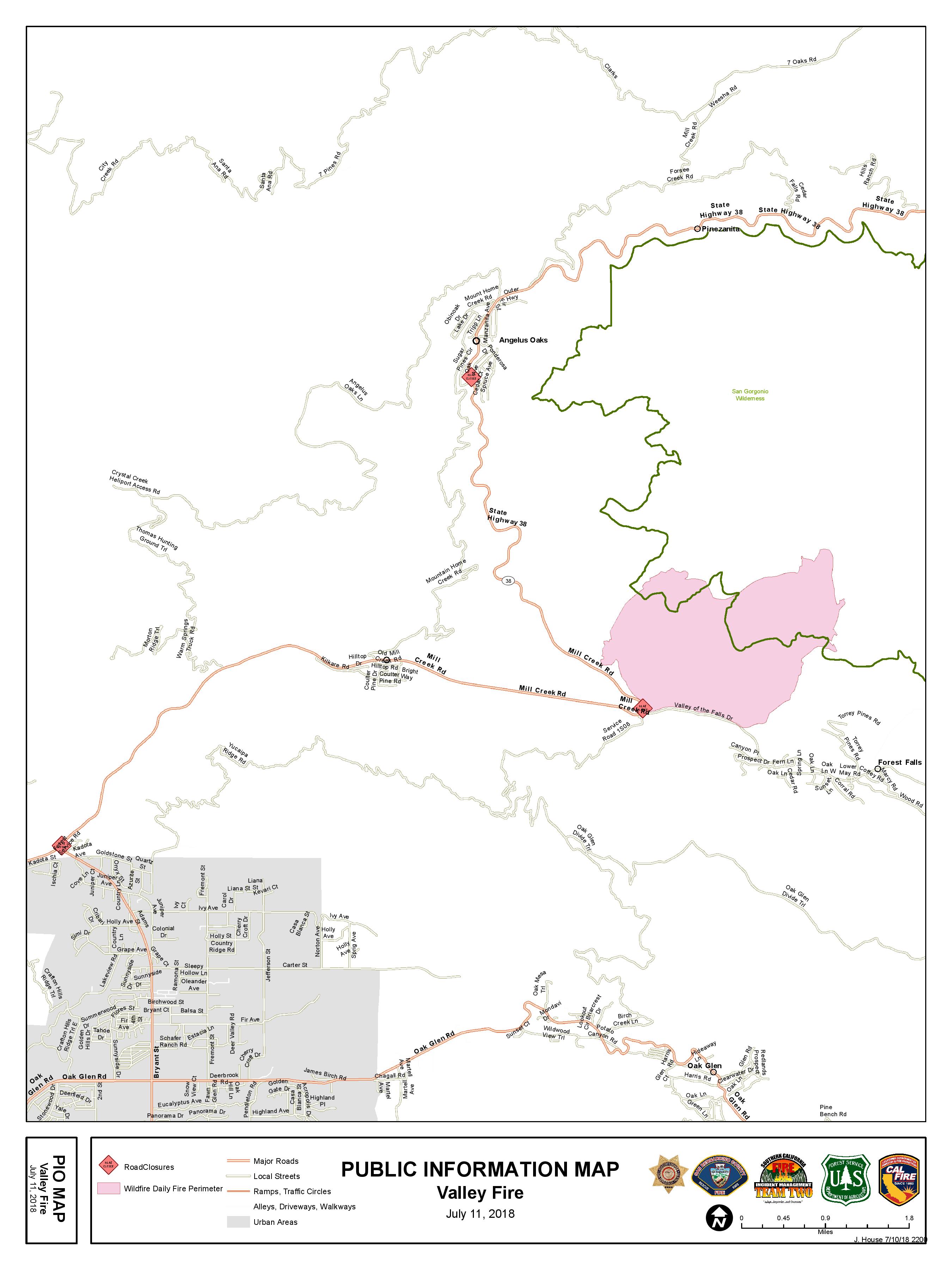
InciwebValley Fire Map
The Valley fire remains at 1,348 acres and 29 percent contained. It’s at the Valley of the Falls Dr. and Service Road 1S08. According to Inciweb, recent cooler weather and rain reduced the fire activity and minimal to no growth is projected. Highway 38 is now open to all traffic, but use caution. Inciweb noted: “All portions of the San Gorgonio Wilderness managed by the USDA Forest Service are closed to entry, including Momyer Trail, Vivian Creek Trail, San Bernardino Peak Trail, Forsee Creek Trail, South Fork Trail, and Aspen Grove Trail. Big Falls Picnic Area, Thurman Flats, and the Mill Creek Visitor Center are open.”