CAL FIRE & Google Maps California fires near me
Fires are still a problem in California, with the Yosemite fire being among the largest at the moment. Here is a list, with maps, of the larger fires around the state, their current containment levels, and where they are located for July 17. Read on for more details. This post was originally written on July 16, but has been updated with July 17 fire details. News is constantly changing, so call your local officials if you are concerned about evacuations near you.
General Map of California Fires
This map below is an interactive map of some of the bigger fires in California on July 17, provided by CAL FIRE and Google. Fires in red are active and fires in black are contained. Read the next section for details about the fires listed on the map.
The California Governor’s office has another active fire map for comparison, which is embedded below. This map periodically is made available only to those with a login, so if it’s not available when you’re reading this story, it might be released to the public again later.
Below is another active fire map from Google’s Crisis Map. Zoom in to areas of interest.
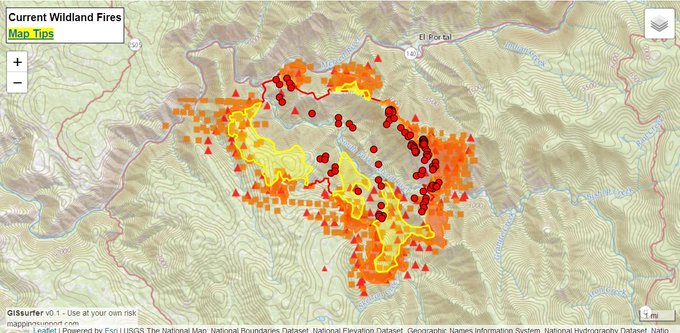
And here’s a map from July 17:
7/17 wildfire map of BLM-managed public lands. Follow fire info @inciweb → t.co/IDvGqBylED & @CAL_FIRE → t.co/F2s9h9A5Ld #KlamathonFire #SteamboatFire #StoneyFire #ValleyFire #GeorgesFire #FergusonFire #EagleFire

List of Active Fires in California as of July 17
Here are the active fires and updates about them, per CAL FIRE. Most of these are in alphabetical order, but newer fires not yet listed on the CAL FIRE map may be included in a separate section at the end.
3_10 Fire
Firefighters are battling a 40 acre fire at Hwy 299 E and Little Valley Rd, Dixie Valley Peak, 16 miles east of Fall River Mills (Lassen County). #3_10Fire

This fire is at Highway 299 E and Little Valley Road in Dixie Valley Peak. It’s 16 miles east of Fall River Mills in Lassen County. It’s 56 acres and 70 percent contained (an increase in 20 percent containment since yesterday.)
3_16 Fire
Firefighters are battling a 30 acre fire off Little Valley Road, north of Little Valley (Lassen County). #3_16Fire
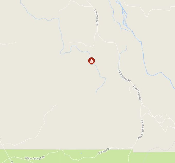
This fire is off Little Valley Road, north of Little Valley in Lassen County. It’s 89 acres and 70 percent contained, up from 50 percent yesterday.
3_18 Fire
This fire is at Punkin CenterRoad and Juniper Road, six miles southeast of the Community of Bieber in Lassen County. It’s 32 acres and 70 percent contained.
County Fire
This fire is now listed as inactive.
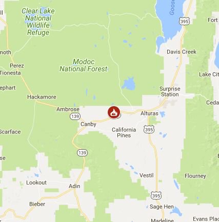
Eagle Fire
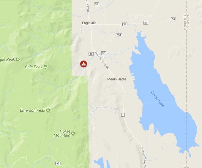
#EagleFire [update] Fire crews dispatched by the Susanville Interagency Fire Center & @ModocNF are fighting the Eagle Fire near Eagleville in NE CA. Please stay out of the Emerson Canyon area & be aware of fire traffic. Fire info @inciweb: t.co/JPq5WytXoP
This fire is at County Road 40/County Road 1, southwest of Eagleville in Modoc County. It’s 2,100 acres and 67 percent contained, located at 41.285 latitude, -120.115 longitude. In just a day, it’s increased from 30 percent to 67 percent containment with no increase in acreage. Total containment is estimated for July 20.
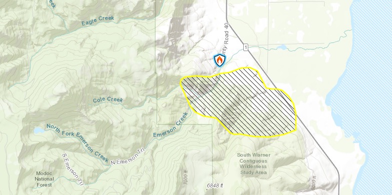
BLM & InciwebEagle Fire Map
It’s 15 miles south of Cedarville, and may be a threat to ranch homes and habitats for the greater sage grouse, according to Inciweb.
CAL FIRE is assisting the BLM Northern District (NOD) with a wildfire at County Rd 40/ County Rd1, southwest of Eagleville (Modoc County). #EagleFire
Ferguson Fire (Yosemite Fire)
Tuesday 7/17 #FergusonFire. 12,314 acres per overnight analysis of infrared data by fire staff. For the legend please click “Map tips” in upper left corner. Open online map: t.co/8PTlbmdSAz #GeoSpatial
This fire is off Highway 140 and Hite Cove, near El Portal in Mariposa County. It’s burning west of Yosemite National Park. It’s 12,525 acres (up from just above 9,000 yesterday) and 5 percent contained.
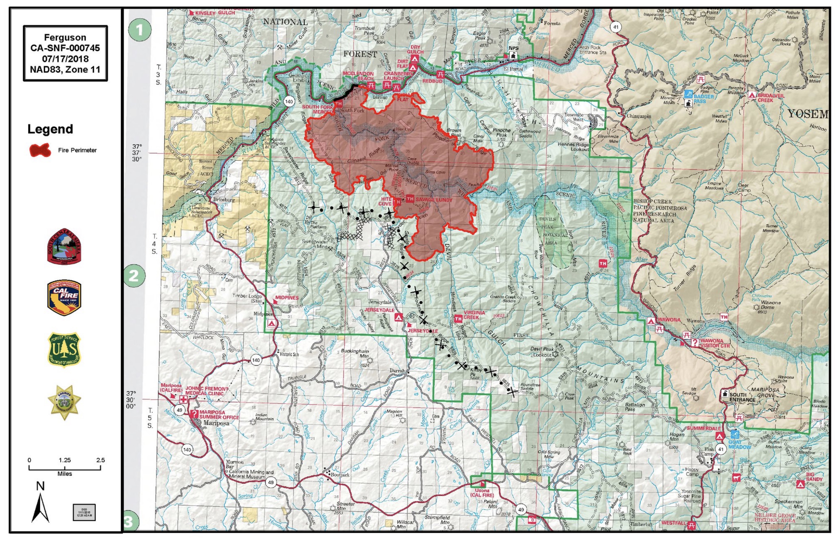
InciwebFerguson Fire Map
It began in the Merced River canyon near El Portal around 10:35 p.m. on Friday, Merced Sun Star reported, and at the time was less than 200 acres. It’s grown substantially since then.
#FergusonFire [update] off Highway 140 and Hite Cove, Near El Portal (Mariposa County) is now 12,525 acres and 5% contained. Unified Command: @CALFIRESKU , @Sierra_NF and @MariposaSheriff: t.co/E5lqAq9muX
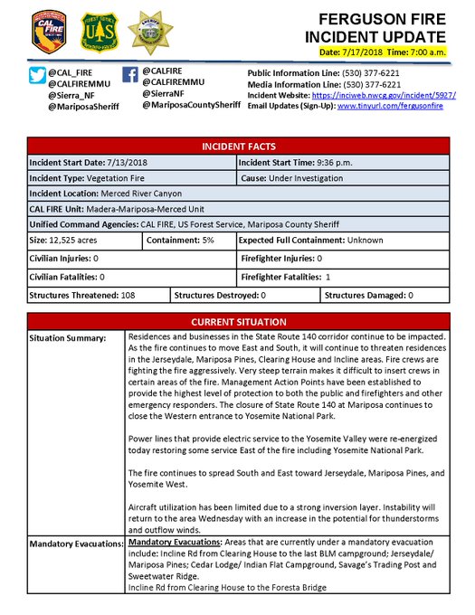

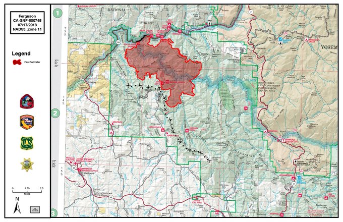
According to Inciweb, the fire continues to move east and south and will threaten residences in the Jerseydale, Mariposa Pines, Clearing House, and Incline areas. It’s located at 37.652 latitude, -119.881 longitude. The cause of the fire in the Savage Trading Post area is currently unknown.
According to Inciweb regarding evacuations: “Areas that are currently under a mandatory evacuation include: Incline Rd from Clearing House to the last BLM campground; Jerseydale/ Mariposa Pines; Cedar Lodge/ Indian Flat Campground, Savage’s Trading Post and Sweetwater Ridge. Incline Rd from Clearing House to the Foresta Bridge.”
Visitors say they can’t even see Half Dome because of all the smoke choking Yosemite National Park t.co/iml44Luj9W #FergusonFire
And the following areas are under an evacuation advisory, according to Inciweb on the morning of July 17. This is not an evacuation order, but an advisement that conditions might change and require an evacuation in the future:
- Yosemite West
- Lushmeadows Community
- Ponderosa Basin Community
- Triangle Rd from Jerseydale Rd to Hwy 49 South including all side roads.
- Darrah Rd from Triangle to Sherrod Rd
- East side of Hwy 49S from Darrah Rd to Harris Rd- This includes Boyer Rd, Woodland Area, Wass Rd, Tip Top Rd
- National Park Service El Portal Complex
- Rancheria Flat- Government Housing
- El Portal Trailer Court
- Old El Portal
Highway 140 is closed from Abbie Rd in El Portal to 14 miles north of Mariposa, Inciweb reported. Also closed are Incline Road, River Road from Briceburg to the gate at Railroad Flat, and campground areas. Hites Cove/Jerseydale Road may also be closed.
Below is a map of the fire from Google’s Crisis Map, which you can see here. Zoom in for more details.
An evacuation center is set up at New Life Christian Fellowship in Mariposa.
Georges Fire
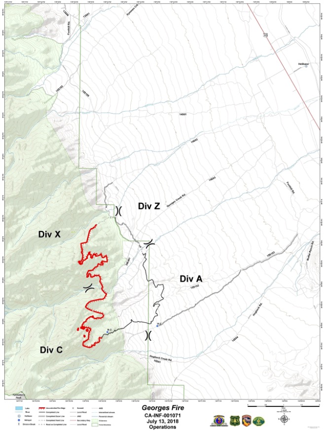
InciwebGeorges Fire Map
This fire is off Hogack and Whitney Portal Road in Alabama Hills, Inyo County. It’s now 2,833 acres and 42 percent contained. It was caused by lightning.
Kelley Fire
This fire is at Highway 299 E and County Road 74, west of Devils Garden Conservation Camp in Modoc County. It’s listed as active on CAL FIRE’s map but it doesn’t seem to have a list on Inciweb.
#RT @CAL_FIRE: CAL FIRE is assisting the @ModocNF with a wildfire off Hwy 299 E & County Rd 74, west of Devils Garden Conservation Camp (Modoc County). #KelleyFire t.co/SwqL7wDq9I
Klamathon Fire
#KlamathonFire {UPDATE} 38,008 acres and 96% contained
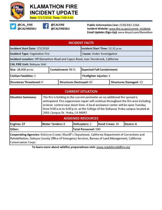
This fire was listed as inactive on July 16, but as of July 17 is listed as active again on CAL FIRE’s map, stating it’s 38,008 acres and 96 percent contained. Eighty-two structures were destroyed. No additional fire spread is anticipated.
Steamboat Fire
#STEAMBOATFIRE {UPDATE} Shasta Valley Wildlife Area, 4 miles south east of Montague ( Siskiyou County) 224 Acres and 70% Contained. The Shasta Valley Wildlife Area is Closed due to the fire.

This fire is off Ball Mountain Road in the Shasta Valley Wildlife Refuge Area, four miles southeast of Montague in Siskiyou County. It’s 224 acres and 80 percent contained, up 10 percent in containment since yesterday.
Stoney Fire
This fire is at Upper Park Road in Bidwell Park in Butte County. It’s 962 acres and 90 percent contained. According to CAL FIRE, evacuation orders have been lifted.
Tennessee Fire
CAL FIRE is assisting the Oregon Department of Forestry with a fire west of Hwy 199, 4 mi northwest of Cave Junction, OR #TennesseeFire ***This is not a CAL FIRE incident. Click on the link for more information. t.co/unO3FzYI2R
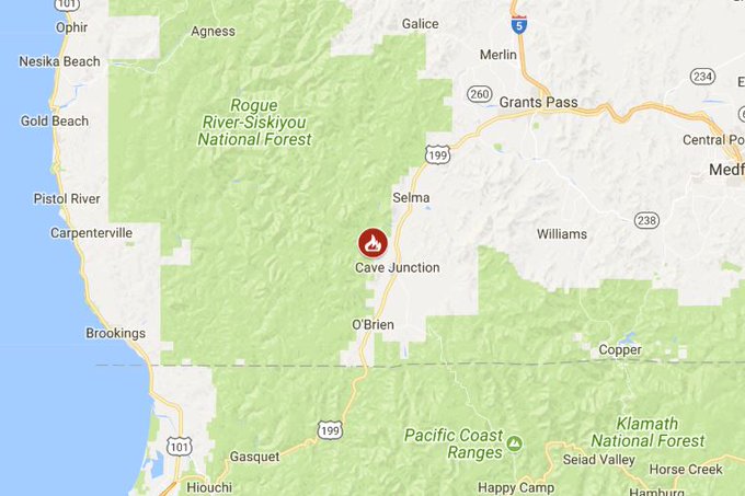
This fire is west of Highway 199, four miles northwest of Cave Junction, Oregon.
Valley Fire
The Valley fire remains at 1,348 acres and 29 percent contained. It’s at the Valley of the Falls Dr. and Service Road 1S08. According to Inciweb, minimal to no growth is expected and very little fire spread is expected. Inciweb may not continue to issue updates after July 16. However, they noted that the fire has increased the risk of landslides in the area, which could be exacerbated by rain. Highway 38 is open to all traffic.
Additional Fires Not on CAL FIRE Map
Sometimes fires crop up temporarily, before they are added to CAL FIRE’s map. We’ll list those below.
Pismo Beach Fire / Maddie Fire
Small fires have been reported along Highway 101 in Shell Beach around Pismo, KSBY reported. Forward progress on the fires has been stopped. The first fires were reported around 3:45 p.m. One was burning near the northbound lanes at Spyglass Drive and burned about 1/4 acre of grass. One of these fires was referred to as the Maddie Fire.