Google Maps
Hot summer conditions are causing fires to continue growing in Colorado. Here are where all the current fires are located, along with maps and evacuation updates.
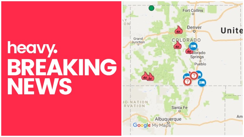
General Map of Colorado Fires
This map below is an interactive map of some of the bigger fires in Colorado right now, provided by the Colorado Division of Fire Prevention & Control (CDFPC) and Google. Fires in red are active and fires in black are contained.
The map above lists numerous active fires, which this article will describe in more detail in the next section.
List of Active Fires in Colorado as of June 30
416 Fire
This fire is 51,068 acres and 37 percent contained. It’s located in La Plata County. The cause of this fire is unknown. It’s located 13 miles north of Durango and has been burning since June 1. It’s burning in an area of inaccessible terrain and no homes have yet been evacuated. Some are on a pre-evacuation notice.
Burro Fire
🔥Fire at night! Check out this incredible image showing the #416fire and #BurroFire at 2:30am. Believe it or not this image was taken at night and shows the glow of wildfire flames from space! The lights from various towns nearby show up as well. @SanJuanNF @NOAASatellites #COwx
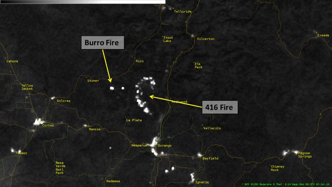
This fire is 4,415 acres and is 40 percent contained. The cause is under investigation and the estimated containment date is currently August 1. It started on June 8 and is located about 14 miles south of Rico.
Divide Fire
This fire has been contained.
High Chateau Fire
New map as of 10:36am this morning. #TCSO #Highchateaufire

This fire is 0 percent contained and 1,328 acres. It started June 29. View a map here. It’s located west of Wright’s Reservoir and northeast of Cripple Creek. It started Friday afternoon. Mandatory evacuations were issued for the High Chateau and Highland Meadows subdivisions, 9 News reported. Mandatory evacuations were also later issued for these subdivisions: Park Ridge, Doe Valley, Pike Meadow, Four Mile Ranch, Olsen Slater Creek, and Ponderosa, for a total of 575 homes, with a further 600 under voluntary evacuation orders.
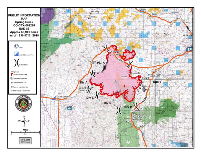
Spring Fire
The Spring Fire is 56,820 acres and 5 percent contained. Evacuations for the fire are currently underway.
🚒🔥 Latest #SpringFire update for 07/02 🔥🚒
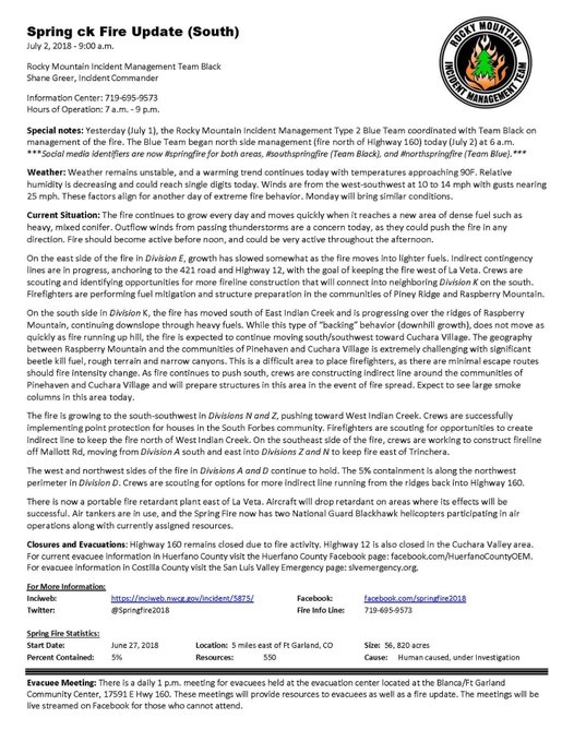
The fire is burning five miles east of Fort Garland and started on Thursday, spreading rapidly. Mandatory evacuations were in place for communities near the fire, and some areas are under pre-evacuation notice. Two evacuation centers were set up, including Huerfano Community Center and one at Blanca Fort Garland Community Center. Evacuation centers for animals are open at the Las Animas County Fairgrounds in Trinidad and at the 4H barn in La Veta, Newsweek reported. To learn more about the fire’s location and evacuations, see Heavy’s story here.
If you’re unsure if your area is under evacuation or need more information, call 719-695-9573 between 7 a.m. to 9 p.m.
Stonemoore Fire
GOOD NEWS! The #StonemooreFire in Pueblo County is now 100 percent contained, according to @PuebloCountySO. Latest: t.co/PW6j1HIzu5 #Denver7 #COFire

This fire is 217 acres and is now 100 percent contained, 9 News reported.
Sugarloaf Fire
This fire was reported June 29 and is 1,311 acres and 0 percent contained. It’s located north of Loveland Pass and 13 miles southwest of Fraser in a remote Grand County area. According to Inciweb, trails, roads, and campgrounds are anticipated to close.
Weston Pass Fire
. @NWSRiverton IMET trainee enroute to #WestonPassFire near Fairplay, CO #COwx #COFires @PSICC_NF @NWSBoulder t.co/SkUheAkIod

This fire started June 28 and was 1,500 acres, 10 percent contained on Saturday. But it’s since grown and is now 6,417 acres and 0 percent contained.
It was started by lightning and is located 9 miles southwest of Fairplay, in a remote area of Park County. Mandatory evacuations were ordered for all homes between the fire and County Road 22, 9 News reported. Mandatory evacuations were also issued for Black Mountain south of CR22, and for Campground of the Rockies.
South Park Recreation Center is offering free showers to evacuees, firefighters, and any volunteers helping fight the fire.