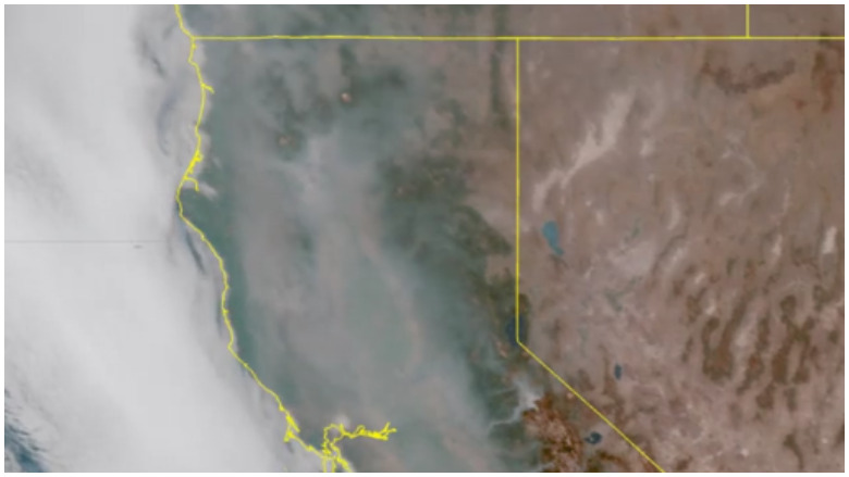
NWS California smoke map
The California fires are sending plumes of smoke across the state and the western segment of the United States. You can see the latest California smoke map video below for August 9, 2018. The National Weather Service’s Sacramento office has been posting daily smoke loop videos that show the air quality degradation from the California wildfires.
Here’s the map for August 9, 2018:
According to the National Weather Service, the smoke map tracks how smoke may move through the area during the day. Smoke was continuing to impact air quality across Northern California.


The smoke was dramatic.
Here’s the August 8 map for comparison purposes:
NWS warned on Wednesday, “Forecast on repeat! Smoke and haze will continue to impact NorCal. Warmer temperatures and increasing fire weather concerns late this week.” On Thursday, the service posted tips for protecting oneself against wildfire smoke:
Among other things, the NWS recommends that people stay indoors and keep windows and doors to their homes shut. According to the National Weather Service, smoke from the California wildfires is impacting much of the western United States.
Another look at how smoke from the California wildfires is spreading over the US and into Canada. #cawx #MendocinoComplex #CarrFire
Air Quality Remains a Concern From the California Fires
You can see updated maps by zip code of local air quality here. The smoke is coming from the Carr, Mendocino Complex, and Donnell fires.
Mendocino County wrote in an air quality and public health report for August 9 and August 10, 2018:
The smoke and haze from the River and Ranch Fires are currently impacting selected areas of eastern Mendocino and all of Lake Counties. Currently air monitors show particulate matter concentrations in the “Unhealthy for Sensitive Groups” to “Unhealthy” range for most of the County. Inland communities and surrounding areas may experience episodes of “Hazardous” air quality. These include Hopland, Ukiah, Calpella, Redwood Valley, Potter Valley, Willits, and Covelo. Portions of Clearlake and all of the north shore are under an “Unhealthy” air quality alert due to heavy smoke conditions. All other areas of Lake County are forecast to have “Moderate” to “Unhealthy” conditions depending on the wind and fire conditions. Based on forecast of continued high pressure and northwesterly winds, existing conditions are expected to continue through at least Wednesday. Please see the accompanying Public Health Advisory for recommendations of personal protection for sensitive groups, as well as, everyone during “Unhealthy”, or more severe, air quality conditions.
The air quality in California is at unhealthy levels for sensitive groups, officials say. They’ve released this health message: “People with heart or lung disease, older adults, and children should reduce prolonged or heavy exertion” as the smoke plumes fill the sky due to the fires.
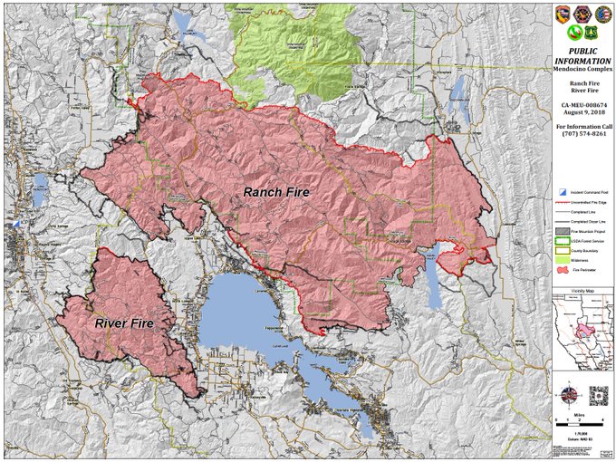
The Mendocino Complex fires are now the largest in California’s history.
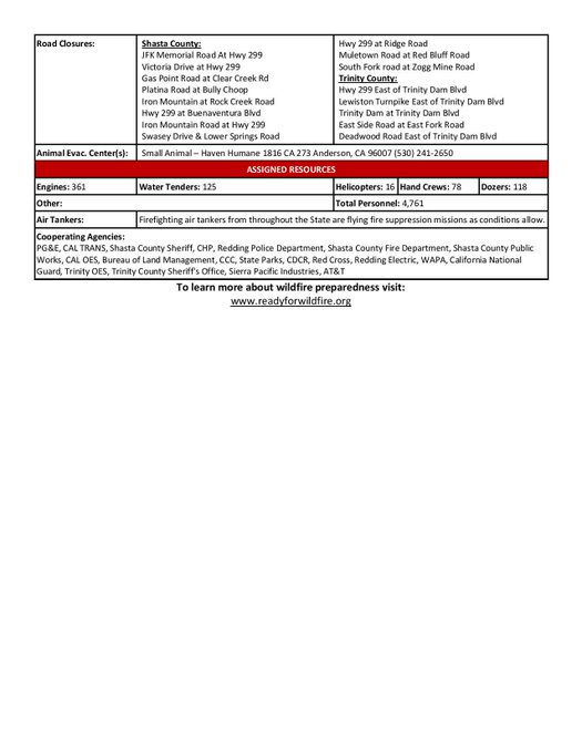
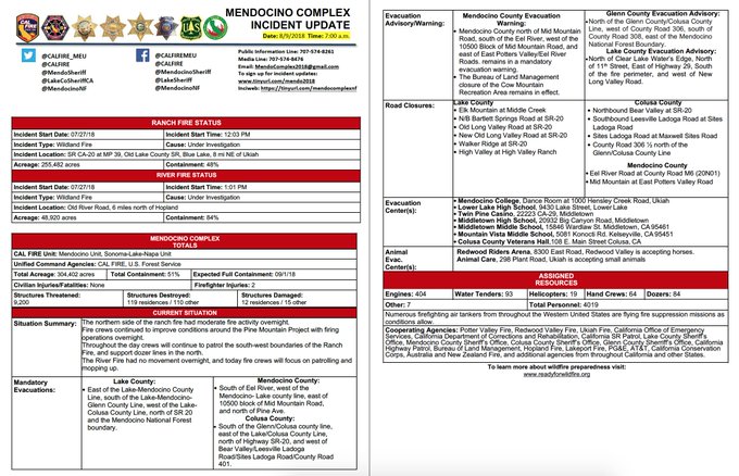
Mendocino Incident Update 8.9 AM #mendocinocomplex @MendoSheriff @lakecosheriffCA @mendocinonf @glenncountyoes
An air quality advisory reads, “Wildfires in Northern California are affecting the air quality of inland communities of Mendocino County.” You can see additional information on the website for the Mendocino County Air Quality Management District. “Mendocino County Air Quality Management District continuously monitors the air quality, reporting particulate matter and ozone concentrations hourly to our website,” the site says, providing this link.
The Carr Fire is now 48 percent contained.
#CarrFire [Update] is now 177,450 acres and 48% contained