NWS Will Hurricane Florence hit Columbia, South Carolina? When?
With Hurricane Florence looming, many people in South Carolina are hoping for the best. However, they should brace for significant impact from the storm.
Will Hurricane Florence hit Columbia, South Carolina? If, so when? According to the National Weather Service, as of the evening of September 13, 2018, hurricane conditions are possible in Columbia on Friday through Saturday.
The NWS Columbia Twitter page has updated information on the area.
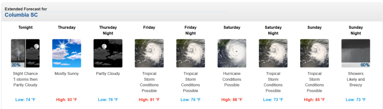
For comparison purposes, this was the forecast the day before.
NWSColumbia SC evening forecast
This was the NWS hazardous weather outlook for Columbia SC on September 13, 2018 in the evening:
“Lancaster-Chesterfield-Newberry-Fairfield-Kershaw-Saluda-
Lexington-Richland-Lee-Sumter-Orangeburg-Calhoun-Clarendon-
Including the cities of Lancaster, Elgin, Lancaster Mill, Cheraw,
Pageland, Newberry, Winnsboro, Winnsboro Mills, Camden, Lugoff,
Saluda, Ridge Spring, Seven Oaks, West Columbia, Cayce,
Lexington, Red Bank, Oak Grove, Columbia, Bishopville, Sumter,
Orangeburg, Brookdale, St. Matthews, Manning, and Summerton
330 PM EDT Thu Sep 13 2018
…FLASH FLOOD WATCH IN EFFECT FROM FRIDAY MORNING THROUGH SUNDAY
EVENING…
The National Weather Service in Columbia has issued a
* Flash Flood Watch for a portion of central South Carolina,
including the following areas, Calhoun, Chesterfield,
Clarendon, Fairfield, Kershaw, Lancaster, Lee, Lexington,
Newberry, Orangeburg, Richland, Saluda, and Sumter.
* From Friday morning through Sunday evening
* Hurricane Florence is expected to slowly move westward towards
the region on Friday, before slowly moving across the northern
portions of the Midlands, the Pee Dee, and Catawba areas over
the weekend. This slow movement combined with prolonged periods
of torrential rainfall may cause flash flooding across the Pee
Dee and Catawba regions, along with portions of the Central and
Northern Midlands.
* Flash flooding of creeks, rivers, streams, nearby roadways, and
washouts of area bridges will become likely. Storm total amounts
of 3 to 8 inches of rainfall may occur across the Central and
Northern Midlands, with storm total amounts of 6 to 18 inches
possible across the Pee Dee, and Catawba regions. Localized
higher amounts also possible.”
Ham operators & SKYWARN Spotters, when WX4CAE is on the air starting tomorrow, ops planned primarily on the CARC 147.360, Bishopville/Lucknow and Little Mountain repeaters. Non-ham spotters, report to us at the contacts given during training. t.co/HzCmK31TYu #caewx #scwx

You can see the NWS page for Columbia here. Get an hourly forecast for Columbia here and see radar of the area here.
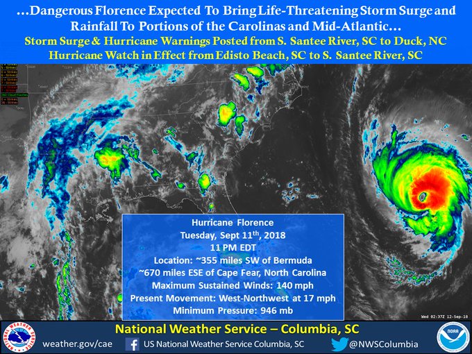
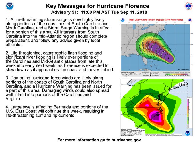
Tue 9/11: Here’s the 11 PM NHC Update. It’s very important to remember that dangerous impacts extend well away from the center of #Florence, & will cover large areas regardless of where the center moves. Prepared yet? #scwx #gawx #caewx #HurricaneFlorence
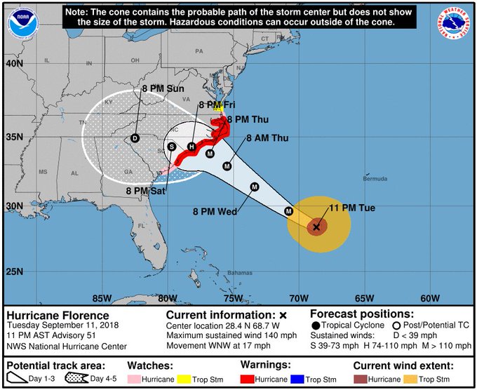
See updated spaghetti models for Hurricane Florence here.
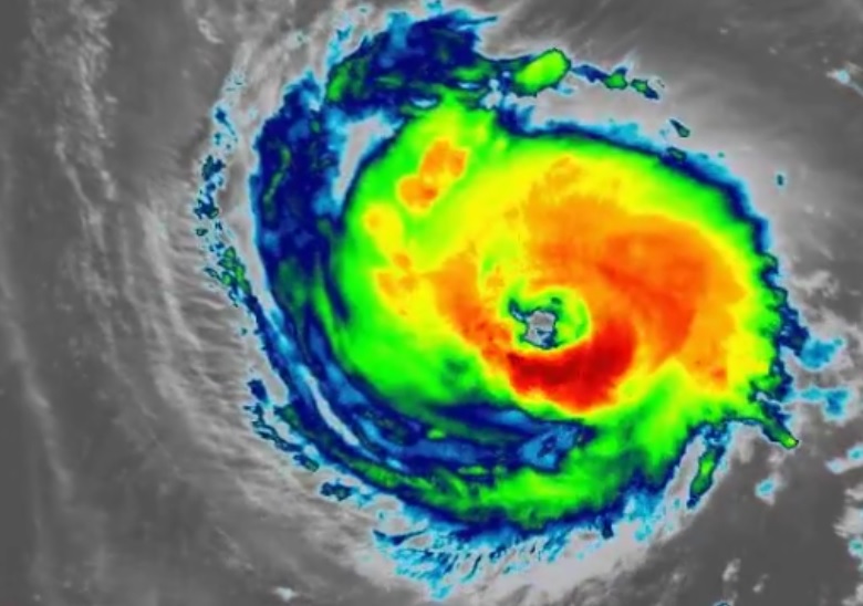
The sun is setting on #Florence as it approaches the Carolina Coast
Get information on South Carolina evacuations here. See the National Weather Services main page for Hurricane Florence here.
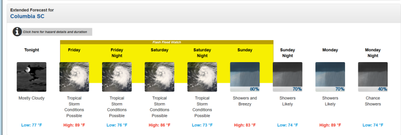
Extended Forecast for Columbia, SC
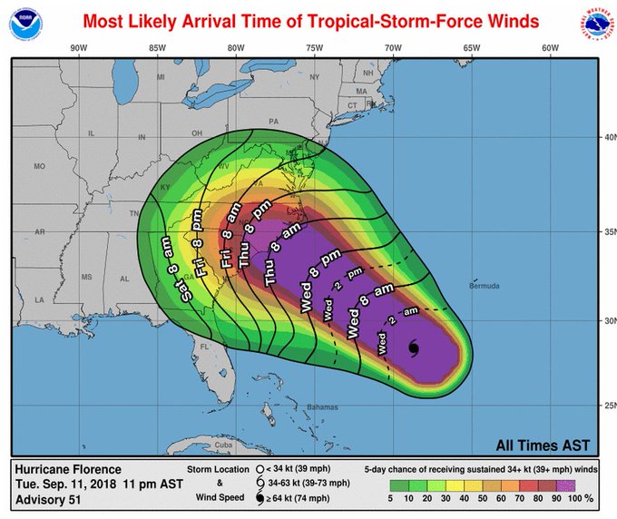
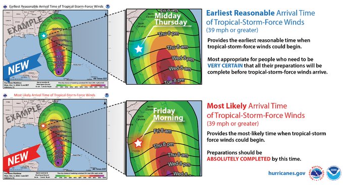
You’ve seen these tropical wind-arrival charts quite often. They’re your best source of official forecast information for planning & preparing. What do they really mean? Here’s the explanation! #scwx #gawx #caewx #Florence #HurricaneFlorence
This is the weather forecast for Columbia, SC, provided by the National Weather Service on September 13, 2018:
“Tonight (September 13, 2018)
Mostly cloudy, with a low around 77. Northwest wind 9 to 13 mph.
Friday
Tropical storm conditions possible. A chance of showers and thunderstorms, mainly between 10am and 4pm. Mostly cloudy, with a high near 89. Chance of precipitation is 30%. New rainfall amounts between a tenth and quarter of an inch, except higher amounts possible in thunderstorms.
Friday Night
Tropical storm conditions possible. A chance of showers and thunderstorms. Cloudy, with a low around 76. Chance of precipitation is 50%. New rainfall amounts between three quarters and one inch possible.
Saturday
Tropical storm conditions possible. Showers likely and possibly a thunderstorm. Mostly cloudy, with a high near 86. Chance of precipitation is 60%. New rainfall amounts between three quarters and one inch possible.
Saturday Night
Tropical storm conditions possible. Showers likely and possibly a thunderstorm. Cloudy, with a low around 73. Chance of precipitation is 70%. New rainfall amounts between three quarters and one inch possible.
Sunday
Showers and possibly a thunderstorm. High near 83. Breezy. Chance of precipitation is 80%. New rainfall amounts between three quarters and one inch possible.
Sunday Night
Showers likely. Mostly cloudy, with a low around 74. Chance of precipitation is 70%.
Monday
Showers likely. Partly sunny, with a high near 89. Chance of precipitation is 70%.
Monday Night
A chance of showers. Mostly cloudy, with a low around 74. Chance of precipitation is 40%.
Tuesday
A chance of showers and thunderstorms. Mostly sunny, with a high near 92. Chance of precipitation is 30%.
Tuesday Night
Partly cloudy, with a low around 73.
Wednesday
Mostly sunny, with a high near 91.
Wednesday Night
Partly cloudy, with a low around 71.
Thursday
Sunny, with a high near 90.”