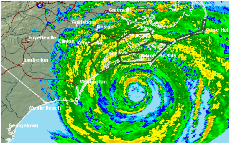
NWS New Bern NC was already experiencing flooding.
With Hurricane Florence now heading toward the North Carolina coast, folks in Greensboro, NC are wondering when the hurricane will arrive and to what degree it will affect them.
According to the National Weather Service’s office that serves Greensboro, NC, the community is only expected to see tropical storm conditions, not hurricane conditions. Be aware that all forecasts are just that. They are predictions and could always change. Tropical storm conditions are expected during the day and evening of September 14, 2018:
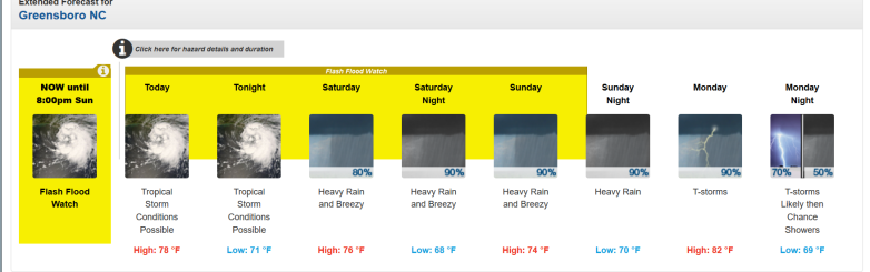
Here was the extended forecast as of the evening of September 13, 2018:
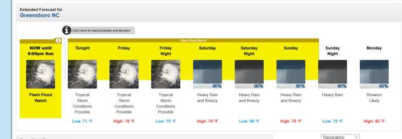
So, you can see how the storm has progressed, here is the extended forecast for Greensboro as of the evening of September 12, 2018:
Greensboro NC weather forecast
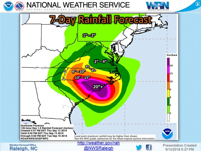
The National Weather Service office serving Raleigh (and Greensboro) released this detailed handout on Hurricane Florence:
You can see the NWS page for Greensboro here.
A look at the current (graphic) and max wind gusts from across central #NCwx. t.co/khnOjFhR5c

See updated spaghetti models here. See the National Weather Service’s Hurricane Florence page here.
Hurricane #Florence made landfall early Friday, and deteriorating weather conditions are expected today. Heavy rain is expected to persist through the weekend, likely leading to catastrophic flooding across portions of #NCwx. Get the latest: t.co/2SQKH6G0vB

See the hourly forecast for Greensboro here. (It lists Raleigh because that is the NWS office that serves Greensboro).
A look at Hurricane #Florence as it makes landfall near Wrightsville Beach #NCwx. Official landfall stats: 90mph Cat 1 Hurricane, 7:15pm (11:15 UTC), 958mb Pressure. Get the latest info: t.co/2SQKH6G0vB
The NWS hazardous weather outlook for Greenboro read on September 14, 2018:
“Hazardous Weather Outlook
National Weather Service Raleigh NC
721 AM EDT Fri Sep 14 2018
NCZ021>025-038-039-073-074-083-151200-
Forsyth-Guilford-Alamance-Orange-Durham-Davidson-Randolph-Stanly-
Montgomery-Anson-
721 AM EDT Fri Sep 14 2018
…FLASH FLOOD WATCH IN EFFECT THROUGH SUNDAY EVENING…
This Hazardous Weather Outlook is for central North Carolina.
.DAY ONE…Today and Tonight.
Please listen to NOAA Weather Radio or go to weather.gov on the
Internet for more information about the following hazards.
Flash Flood Watch.
.DAYS TWO THROUGH SEVEN…Saturday through Thursday.
Please listen to NOAA Weather Radio or go to weather.gov on the
Internet for more information about the following hazards.
In addition, isolated tornadoes will be possible on Sunday.
Flash Flood Watch.”
Biggest change in the forecast with this afternoon’s package is the expected rainfall amounts across portions of southern #NCwx from #Florence. Widespread 6 – 10″ expected with many along the border in the 15 – 25″ + range. Download the latest briefing: t.co/PCyRlBYFOU
Get evacuation information for North Carolina here.
Extended Weather Forecast for Greensboro, South Carolina
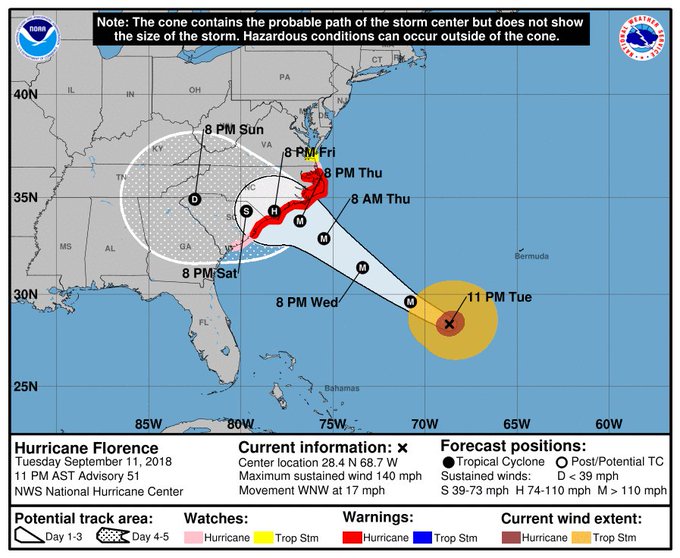
The 11 PM update from @NHC_Atlantic keeps #Florence as a Category 4 hurricane with max winds at 140 mph. The new forecast track is slower and farther south, but it still has Florence approaching the NC/SC coast as a major hurricane late Thursday into Friday. #ncwx
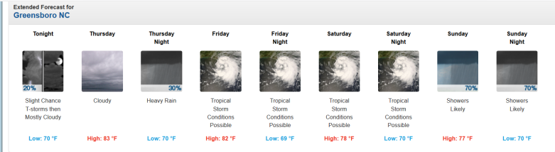
This was the extended weather forecast from NWS for Greensboro as of the evening September 14, 2018:
“Today (September 14, 2018)
Tropical storm conditions possible. Showers likely and possibly a thunderstorm. Some of the storms could produce heavy rainfall. Cloudy, with a high near 78. Chance of precipitation is 70%. New rainfall amounts between a tenth and quarter of an inch, except higher amounts possible in thunderstorms.
Tonight
Tropical storm conditions possible. Showers likely and possibly a thunderstorm. Some of the storms could produce heavy rainfall. Cloudy, with a low around 71. Chance of precipitation is 70%. New rainfall amounts between three quarters and one inch possible.
Saturday
Showers and possibly a thunderstorm. Some of the storms could produce heavy rainfall. High near 76. Breezy, with a northeast wind around 22 mph, with gusts as high as 33 mph. Chance of precipitation is 80%. New rainfall amounts between 1 and 2 inches possible.
Saturday Night
Showers and possibly a thunderstorm. Some of the storms could produce heavy rainfall. Low around 68. Breezy, with a northeast wind 17 to 22 mph, with gusts as high as 33 mph. Chance of precipitation is 90%. New precipitation amounts between 1 and 2 inches possible.
Sunday
Showers. The rain could be heavy at times. High near 74. Breezy, with an east wind 15 to 20 mph, with gusts as high as 30 mph. Chance of precipitation is 90%. New precipitation amounts between 1 and 2 inches possible.
Sunday Night
Showers. The rain could be heavy at times. Low around 70. Chance of precipitation is 90%. New precipitation amounts between three quarters and one inch possible.
Monday
Showers, with thunderstorms also possible after 9am. High near 82. Chance of precipitation is 90%.
Monday Night
Showers and thunderstorms likely before 9pm, then a chance of showers. Mostly cloudy, with a low around 69. Chance of precipitation is 70%.
Tuesday
A chance of showers, with thunderstorms also possible after 9am. Partly sunny, with a high near 84. Chance of precipitation is 50%.
Tuesday Night
A chance of showers and thunderstorms before 9pm. Mostly cloudy, with a low around 67. Chance of precipitation is 40%.
Wednesday
Mostly sunny, with a high near 85.
Wednesday Night
Mostly clear, with a low around 65.
Thursday
Sunny, with a high near 82.”