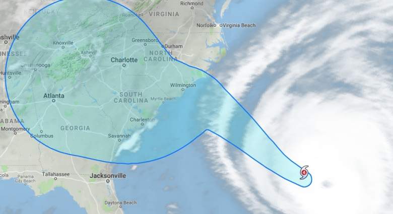
The city of Greenville, North Carolina has issued a hurricane warning for the area, with Mayor P.J. Connelly declaring a state of emergency for the city as of Tuesday, September 11.
As of now, Hurricane Florence is projected to hit Greenville as early as Thursday, September 13. Here’s what you need to know about the forecast for Greenville.
Seven Day Forecast for Greenville, NC
Per the National Weather Service, here is the week’s forecast for Greenville, NC, with Hurricane Florence estimated to hit on Thursday:
Tonight: A chance of showers and thunderstorms, mainly after 5am. Mostly cloudy, with a low around 74. Northeast wind 7 to 9 mph. Chance of precipitation is 30%. New rainfall amounts of less than a tenth of an inch, except higher amounts possible in thunderstorms.
Thursday: Tropical storm conditions expected, with hurricane conditions possible. A chance of showers and thunderstorms, then showers and possibly a thunderstorm after 8am. Some of the storms could produce heavy rainfall. High near 84. Chance of precipitation is 80%. New rainfall amounts between a tenth and quarter of an inch, except higher amounts possible in thunderstorms.
Thursday Night: Tropical storm conditions expected, with hurricane conditions possible. Showers and possibly a thunderstorm. Some of the storms could produce heavy rainfall. Low around 75. Chance of precipitation is 90%. New rainfall amounts between 1 and 2 inches possible.
Friday: Tropical storm conditions possible. Showers and possibly a thunderstorm. Some of the storms could produce heavy rainfall. High near 82. Chance of precipitation is 100%. New rainfall amounts between 2 and 3 inches possible.
Friday Night: Tropical storm conditions possible. Showers and possibly a thunderstorm. Low around 73. Chance of precipitation is 90%. New rainfall amounts between 1 and 2 inches possible.
Saturday: Tropical storm conditions possible. Showers and possibly a thunderstorm. High near 83. Chance of precipitation is 80%.
Saturday Night: Showers and thunderstorms likely. Cloudy, with a low around 72. Breezy. Chance of precipitation is 60%.
Sunday: Showers and thunderstorms likely. Mostly cloudy, with a high near 84. Chance of precipitation is 60%.
Sunday Night: A chance of showers. Mostly cloudy, with a low around 72. Chance of precipitation is 40%.
Monday: A chance of showers. Mostly cloudy, with a high near 85. Chance of precipitation is 50%.
Monday Night: A chance of showers. Mostly cloudy, with a low around 70. Chance of precipitation is 30%.
Tuesday: A chance of showers. Mostly cloudy, with a high near 85. Chance of precipitation is 40%.
Tuesday Night: Mostly cloudy, with a low around 71.
Wednesday: A chance of showers and thunderstorms. Partly sunny, with a high near 86.
Flash Flooding Watch Issued for Greenville Area
The National Weather Service issued the following flash flooding warning for the Greenville area:
…FLASH FLOOD WATCH REMAINS IN EFFECT FROM THURSDAY EVENING
THROUGH SATURDAY EVENING…
The Flash Flood Watch continues for
* A portion of eastern North Carolina, including the following
areas, Beaufort, Greene, Mainland Dare, Mainland Hyde, Martin,
Outer Banks Dare, Pitt, Tyrrell, and Washington.
* From Thursday evening through Saturday evening
* Widespread and extremely heavy rain associated with Hurricane
Florence will begin Thursday and continue into the weekend.
Rainfall totals of 6 to 12 inches will be possible over the
northern tier through Saturday with locally higher amounts.
* Significant Flash Flooding can be expected.
PRECAUTIONARY/PREPAREDNESS ACTIONS…
A Flash Flood Watch means that conditions may develop that lead
to flash flooding. Flash flooding is a very dangerous situation.
You should monitor later forecasts and be prepared to take action
should Flash Flood Warnings be issued.
Per WNCT, here are a list of potential areas in Greenville that will be prone to flooding:
• 14th Street and Charles Street (Both sides of Rite-Aid)
• 10th Street and College Hill
• 1st Street and Brownlea Drive
• Reade Street and Cotanche Street
• Evans Street and Deck Street
• Evans Street and Arlington Boulevard
• Dickinson Avenue Underpass
• Old Tar Road
Available Shelters in the Greenville, NC Area
Here is a list of the shelters that will be open to evacuated residents as of Wednesday evening, September 12:
- Wellcome Middle School, 3101 North Memorial Drive, Greenville
- E.B. Aycock Middle School, 1325 Red Banks Road, Greenville
- Hope Middle School, 2995 Mills Road, Greenville
- Ayden Middle School, 192 Third Street, Ayden
- Farmville Middle School, 3914 Grimmersburg Road, Farmville

