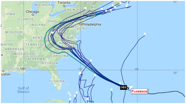
As Hurricane Florence gathers strength, many people are looking for ways to track the storm. There are several sites that provide constantly updated and live spaghetti models that show the hurricane’s path.
You can see links to some of the best sites to do so below. The hurricane, in the recent spaghetti models, appeared to be veering toward the North Carolina coast and Virginia, perhaps sparing South Carolina the worst of the storm. However, hurricanes can be unpredictable and shift course.
“We face three critical threats from Florence: ocean surge along our coast, strong winds, and inland flooding from heavy rain,” North Carolina’s Gov. Roy Cooper said. “Wherever you live in North Carolina, you need to get ready for this storm now, and you need to evacuate if asked to.” You can see a listing of North Carolina counties that ordered evacuations as of September 11, 2018. Virginia evacuation information can be found here and South Carolina information is rounded up here.
Spaghetti model plots were all showing a similar track. Here’s another one.
Here are some sites that have constantly updated spaghetti models for Hurricane Florence:
Cyclocane
Cyclocane is one of the best sites that has constantly updated Hurricane Florence spaghetti models. You can access that site’s spaghetti models here. As of the early morning of September 11, 2018, the Cyclocane spaghetti model showed the hurricane making landfall in North Carolina.
The Cyclocane Hurricane Florence page contains other useful information, such as radar loops and imagery and watches and warnings.
NOAA
NOAA is also a good site to check for constantly updated spaghetti models. You can access the page here. The drop-down menu on the site allows you to narrow the spaghetti model maps by storm. Look for the “storm ID” tab in the top left of the page to zoom in on Hurricane Florence spaghetti models.
The NOAA spaghetti models for Hurricane Florence also show the storm turning north and threatening North Carolina and Virginia more than South Carolina at the moment. NOAA stands for the The National Oceanic and Atmospheric Administration.
Other Spaghetti Models
The South Florida Water Management District has a page of updated spaghetti models for hurricanes, including Florence. You can access it here.
Choose “storm 6” on the site to see Hurricane Florence plots.
National Weather Service
You can access the National Weather Service’s Hurricane Florence page here.
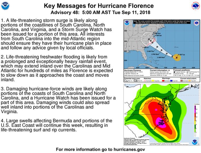
NWS released this alert on the morning of September 11, 2018:
HURRICANE FLORENCE FORECAST/ADVISORY NUMBER 48
NWS NATIONAL HURRICANE CENTER MIAMI FL AL062018
0900 UTC TUE SEP 11 2018CHANGES IN WATCHES AND WARNINGS WITH THIS ADVISORY…
A STORM SURGE WATCH HAS BEEN ISSUED FOR THE EAST COAST OF THE UNITED STATES FROM EDISTO BEACH…SOUTH CAROLINA NORTHWARD TO THE NORTH CAROLINA-VIRGINIA BORDER…INCLUDING THE PAMLICO AND ALBEMARLE SOUNDS.
A HURRICANE WATCH HAS BEEN ISSUED FOR THE EAST COAST OF THE UNITED STATES FROM EDISTO BEACH… SOUTH CAROLINA… NORTHWARD TO THE NORTH CAROLINA-VIRGINIA BORDER… INCLUDING THE PAMLICO AND ALBEMARLE SOUNDS.
SUMMARY OF WATCHES AND WARNINGS IN EFFECT…
A STORM SURGE WATCH IS IN EFFECT FOR…
* EDISTO BEACH SOUTH CAROLINA TO THE NORTH CAROLINA-VIRGINIA BORDER
* ALBEMARLE AND PAMLICO SOUNDS…INCLUDING THE NEUSE AND PAMLICO RIVERSA HURRICANE WATCH IS IN EFFECT FOR…
* EDISTO BEACH SOUTH CAROLINA TO THE NORTH CAROLINA-VIRGINIA BORDER
* ALBEMARLE AND PAMLICO SOUNDSINTERESTS ELSEWHERE IN THE SOUTHEASTERN AND MID-ATLANTIC STATES SHOULD MONITOR THE PROGRESS OF FLORENCE. ADDITIONAL WATCHES MAY BE REQUIRED LATER TODAY.
A STORM SURGE WATCH MEANS THERE IS A POSSIBILITY OF LIFE-THREATENING INUNDATION… FROM RISING WATER MOVING INLAND FROM THE COASTLINE… IN THE INDICATED LOCATIONS DURING THE NEXT 48 HOURS. FOR A DEPICTION OF AREAS AT RISK… PLEASE SEE THE NATIONAL WEATHER SERVICE STORM SURGE WATCH/WARNING GRAPHIC… AVAILABLE AT HURRICANES.GOV.
A HURRICANE WATCH MEANS THAT HURRICANE CONDITIONS ARE POSSIBLE WITHIN THE WATCH AREA. A WATCH IS TYPICALLY ISSUED 48 HOURS BEFORE THE ANTICIPATED FIRST OCCURRENCE OF TROPICAL-STORM-FORCE WINDS… CONDITIONS THAT MAKE OUTSIDE PREPARATIONS DIFFICULT OR DANGEROUS.
HURRICANE CENTER LOCATED NEAR 26.4N 64.1W AT 11/0900Z
POSITION ACCURATE WITHIN 15 NMPRESENT MOVEMENT TOWARD THE WEST-NORTHWEST OR 290 DEGREES AT 13 KT
ESTIMATED MINIMUM CENTRAL PRESSURE 944 MB
EYE DIAMETER 15 NM
MAX SUSTAINED WINDS 120 KT WITH GUSTS TO 145 KT.
64 KT……. 35NE 25SE 25SW 30NW.
50 KT……. 60NE 50SE 40SW 60NW.
34 KT…….130NE 130SE 80SW 110NW.
12 FT SEAS..240NE 150SE 120SW 180NW.
WINDS AND SEAS VARY GREATLY IN EACH QUADRANT. RADII IN NAUTICAL MILES ARE THE LARGEST RADII EXPECTED ANYWHERE IN THAT QUADRANT.REPEAT…CENTER LOCATED NEAR 26.4N 64.1W AT 11/0900Z AT 11/0600Z CENTER WAS LOCATED NEAR 26.1N 63.3W
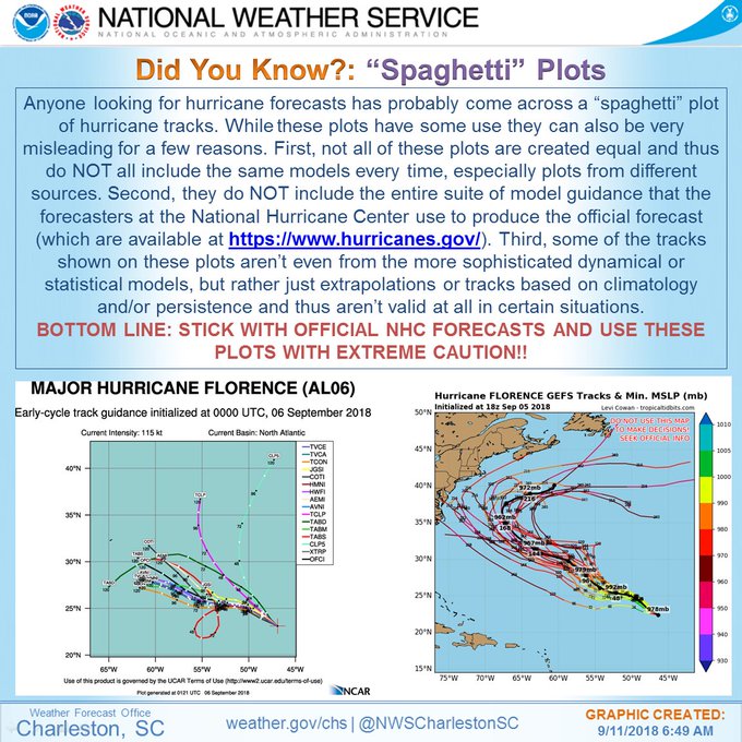
The National Weather Service’s Charleston office did put out a warning about spaghetti models, saying they are not all accurate. Here is that warning:
Some people were skeptical.
READ NEXT: Hurricane Florence Impact on Inland North Carolina

