NWS Will Hurricane Florence hit Raleigh, NC? When?
Hurricane Florence is heading toward North Carolina’s coast, but will the storm hit Raleigh-Durham, North Carolina? If so, when?
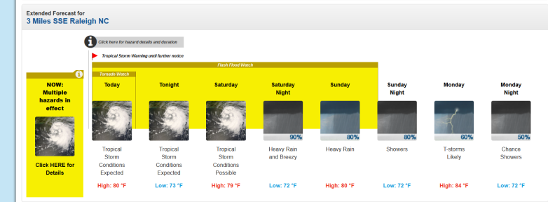
The National Weather Service page for Raleigh-Durham, NC reports that tropical storm conditions are expected on Friday, September 14, 2018 and possible for Saturday. Here’s the forecast as of September 14, 2018:
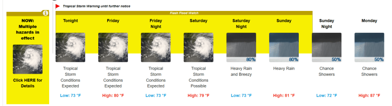
So you can see how things progressed, here is the extended weather forecast for Raleigh Durham as of September 13, 2018, in the evening:

Here’s an update from Friday morning:
Hurricane #Florence made landfall early Friday, and deteriorating weather conditions are expected today. Heavy rain is expected to persist through the weekend, likely leading to catastrophic flooding across portions of #NCwx. Get the latest: t.co/2SQKH6G0vB

That’s a positive shift from the forecast earlier in the day on September 12, when NWS was reporting the possibility of hurricane conditions on Friday night (September 14, 2018) and Saturday for Raleigh-Durham.
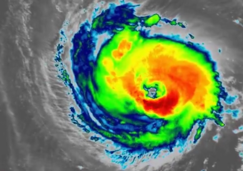
A look at Hurricane #Florence as it makes landfall near Wrightsville Beach #NCwx. Official landfall stats: 90mph Cat 1 Hurricane, 7:15pm (11:15 UTC), 958mb Pressure. Get the latest info: t.co/2SQKH6G0vB
You can see latest radar images for the hurricane here.
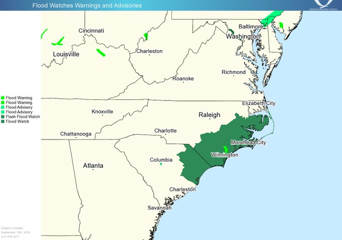
River flooding across central #NCwx from #Florence is a major concern. Know your risks, have an evacuation plan, and pay close attention to the river stages and forecasts. Latest river info: t.co/xbX5BzUTvp
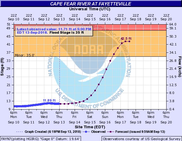
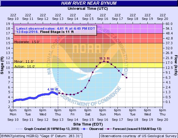
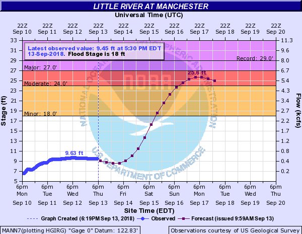

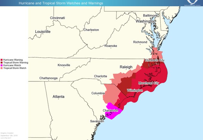
High winds and flooding remain concerns for central North Carolina. “Remember that the forecast “cone” indicates the range of possible paths for the storm’s center. The actual area impacted by Florence will be much larger!” the NWS advised.
Get the latest spaghetti model plots here. See the hourly forecast for Raleigh, North Carolina here. See satellite imagery of the weather patterns over Raleigh here.

The National Weather Service office serving Raleigh released this detailed handout on Hurricane Florence:
“We face three critical threats from Florence: ocean surge along our coast, strong winds, and inland flooding from heavy rain,” Gov. Cooper said. “Wherever you live in North Carolina, you need to get ready for this storm now, and you need to evacuate if asked to.”
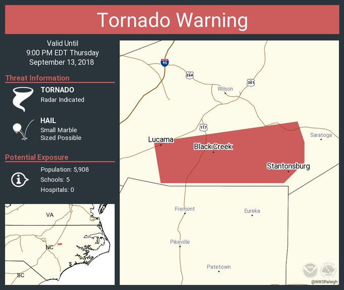
Tornado Warning continues for Lucama NC, Stantonsburg NC, Black Creek NC until 9:00 PM EDT
Here is the hazardous weather outlook for September 14, 2018 in the evening from NWS:
“Hazardous Weather Outlook
National Weather Service Raleigh NC
721 AM EDT Fri Sep 14 2018
NCZ026>028-041>043-077-151200-
Franklin-Nash-Edgecombe-Wake-Johnston-Wilson-Harnett-
721 AM EDT Fri Sep 14 2018
…FLASH FLOOD WATCH IN EFFECT THROUGH SUNDAY EVENING…
…TORNADO WATCH 373 IN EFFECT UNTIL 5 PM EDT THIS AFTERNOON…
…TROPICAL STORM WARNING IN EFFECT…
This Hazardous Weather Outlook is for central North Carolina.
.DAY ONE…Today and Tonight.
Please listen to NOAA Weather Radio or go to weather.gov on the
Internet for more information about the following hazards.
Tornado Watch.
Flash Flood Watch.
Tropical Storm Warning.
.DAYS TWO THROUGH SEVEN…Saturday through Thursday.
Please listen to NOAA Weather Radio or go to weather.gov on the
Internet for more information about the following hazards.
Flash Flood Watch.
Tropical Storm Warning.”
Raleigh-Durham, North Carolina Extended Forecast
645 am… Latest rainfall forecasts indicate 10-15 inches of rain is expected to fall from Hurricane Florence across eastern portions of NC with localized amounts approaching 20 inches. #ncwx

This is the detailed extended weather forecast for Raleigh Durham as of the evening of September 14, 2018:
“Today (September 14, 2018)
Tropical storm conditions expected. Showers and possibly a thunderstorm. Some storms could be severe, with heavy rain. High near 80. Chance of precipitation is 100%. New rainfall amounts between a half and three quarters of an inch possible.
Tonight
Tropical storm conditions expected. Showers and possibly a thunderstorm. Some of the storms could produce heavy rainfall. Low around 73. Chance of precipitation is 90%. New rainfall amounts between 1 and 2 inches possible.
Saturday
Tropical storm conditions possible. Showers and possibly a thunderstorm. Some of the storms could produce heavy rainfall. High near 79. Chance of precipitation is 90%. New rainfall amounts between 1 and 2 inches possible.
Saturday Night
Showers. The rain could be heavy at times. Low around 72. Breezy, with an east wind 15 to 22 mph, with gusts as high as 33 mph. Chance of precipitation is 90%. New precipitation amounts between 1 and 2 inches possible.
Sunday
Showers. The rain could be heavy at times. High near 80. East wind 14 to 16 mph, with gusts as high as 25 mph. Chance of precipitation is 80%. New precipitation amounts between three quarters and one inch possible.
Sunday Night
Showers. Low around 72. Chance of precipitation is 80%. New precipitation amounts between a quarter and half of an inch possible.
Monday
Showers and thunderstorms likely. Cloudy, with a high near 84. Chance of precipitation is 60%.
Monday Night
A chance of showers. Mostly cloudy, with a low around 72. Chance of precipitation is 50%.
Tuesday
A chance of showers and thunderstorms. Partly sunny, with a high near 86. Chance of precipitation is 40%.
Tuesday Night
Mostly cloudy, with a low around 70.
Wednesday
Mostly sunny, with a high near 88.
Wednesday Night
Partly cloudy, with a low around 68.
Thursday
Sunny, with a high near 85.”