S.C. Emergency Management Division
Hurricane Florence is headed toward the United States, and is projected to make landfall in North Carolina on Thursday, September 13. Severe weather is expected along the coast and will affect several towns in South Carolina as well. Officials in the Palmetto State have already started preparing for the impending storm, which could be a Category 4 hurricane by the time it arrives on land.
A State of Emergency Has Been Declared in South Carolina & the Governor Has Issued an Evacuation Order for Horry County
According to Fox News, the governor of South Carolina has already declared a state of emergency. Those living in the area have been encouraged to evacuate.
On Monday, Governor Henry McMaster urged those living in coastal counties, including Horry County, to prepare for a possible evacuation. The evacuation order is set to go into effect on Tuesday, September 11, 2018, and will include Horry County Zones A, B, and C, according to the Horry County Sheriff’s Office.
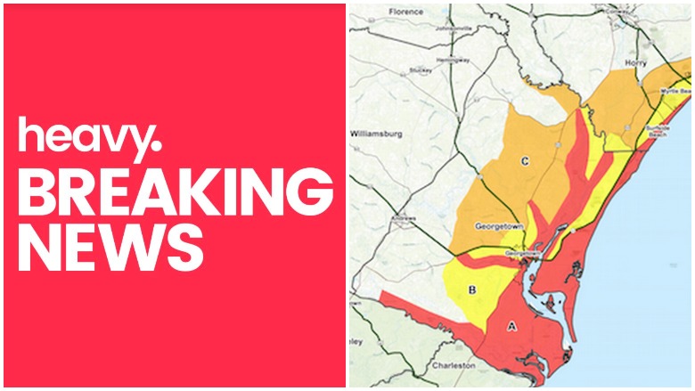
South Carolina’s hurricane evacuation zones are split into three regions. Horry and Georgetown Counties make up the Northern Coast region and consist of three zones, A, B, and C. To find the best routes for your zone to shelters, click here to use ArcGIS.
Evacuation areas for ZONE A include all areas east of U.S. Business 17 up to the intersection with US 17 and all areas east of U.S. 17 to the northern county line.
Evacuation areas for ZONE B include areas South of Highway 707 and Longwood Drive. All areas in Longwood Plantation to the Waccamaw River, all areas east of US 17 Bypass to US 17, and all areas east of US 17 to the northern county line.
Evacuation areas for ZONE C include areas between Hwy 701 and Hwy 544, South of Brown’s Chapel Avenue and Hwy 814. All areas east of Highway 31 (Carolina Bays Parkway) to Hwy 9, and all areas east of Highway 9 to US 17 to the northern county line.
Below is a map of the evacuation routes in Horry County.
Shelters Will Be Available to Residents Needing to Leave Their Homes
Several hurricane shelters are set up in Horry County, but they may not open until the evacuation order goes into effect on Tuesday.
Horry County, Zone A:
- Aynor Middle School, 400 Frye Rd., Galivants Ferry
- Conway High School, 2301 Church St., Conway
- Loris High School, 301 Loris Lions Rd., Loris
- North Myrtle Beach High School, 3705 Sea Mountain Hwy, Little River
- Palmetto Bay Elementary School, 8900 Hwy 544, Myrtle Beach
- Whittemore Park Middle School, 1808 Rhue St., Conway
Additional information about shelters in Horry County is available through the American Red Cross at (843) 477-0020.