
NOAA Hurricane Florence Update
Hurricane Florence is slowly moving toward the southeast U.S. coast, and the National Hurricane Center is providing frequent updates about the storm’s movements. Here are details from the latest update from the NOAA as of 5 p.m. Eastern (4 p.m. Central.) The next update will be at 11 p.m. Eastern, with an intermediary update issued at 8 p.m. Eastern. You can read the full updates on the NOAA’s website here.
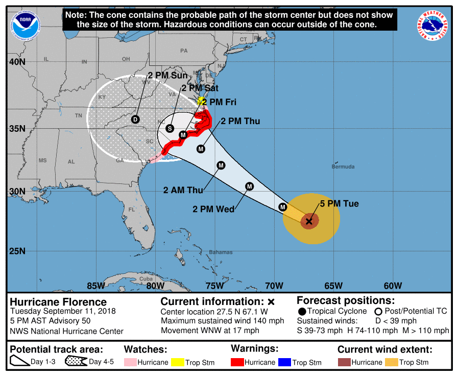
Hurricane Florence’s Location, Coordinates & Movement
NOAANOAA
As of 5 p.m., Florence was located at 27.5 N and 67.1 W, about 360 miles (580 km) SSW of Bermuda and 785 miles (1,260 km) ESE of Cape Fear, North Carolina.
The storm is moving WNW or 300 degrees at 17 mph.
The National Hurricane Center noted the following at 5 p.m.: “A motion toward the west-northwest and northwest is expected through early Thursday. Florence is expected to slow down considerably by late Thursday into Friday. On the forecast track, the center of Florence will move over the southwestern Atlantic Ocean between Bermuda and the Bahamas through Wednesday, and approach the coast of North Carolina or South Carolina in the hurricane warning area on Thursday and Friday.”
Hurricane Florence’s Wind Strength, Pressure, & Rainfall

The storm’s maximum sustained winds as of 5 p.m. are 140 mph, NOAA noted. (That’s 220 km/hour.) That’s a slight strengthening from when the storm appeared to have weakened just slightly earlier today.
The storm’s minimum central pressure is 945 mb or 27.91 inches. The estimated eye diameter is 25 nm, according to NHC.
Some weakening is expected on Thursday, but the storm is still predicted to be an extremely dangerous hurricane when it makes landfall.
Hurricane-force winds extend outward up to 60 miles from the center, and tropical storm force winds extend outward up to 175 miles from the center. Hurricane-force winds may reach the coast within the warning area on Friday. Tropical storm strength winds will be felt on Thursday.
Florence is expected to produce 15 to 25 inches of rain, with isolated maximums up to 35 inches near parts of the Carolinas and Mid-Atlantic states late this week into early next week. This could create the risk of catastrophic flooding, NOAA noted.
Current Watches & Warnings
According to the National Hurricane Center, the following warnings and watches are in effect.
Hurricane Warning
- South Santee River, South Carolina to Duck, North Carolina
- Albermarle and Pamlico Sounds
According to NHC: “A Hurricane Warning means that hurricane conditions are expected somewhere within the warning area. A warning is typically issued 36 hours before the anticipated first occurrence of tropical-storm-force winds, conditions that make outside preparations difficult or dangerous. Preparations to protect life and property should be rushed to completion.”
Hurricane Watch
- Edisto Beach, South Carolina to South Santee River, South Carolina
- North of Duck, North Carolina to the North Carolina/Virginia Border
According to NHC: “A Hurricane Watch means that hurricane conditions are possible within the watch area. A watch is typically issued 48 hours before the anticipated first occurrence of tropical-storm-force winds, conditions that make outside preparations difficult or dangerous.”
Tropical Storm Watch
- North of the North Carolina/Virginia border to Cape Charles Light, Virginia
- Chesapeake Bay south of New Point Comfort
According to NHC: “A Tropical Storm Watch means that tropical storm conditions are possible within the watch area, generally within 48 hours.”
Storm Surge Warning
- South Santee River, South Carolina to Duck, North Carolina
- Albemarle and Pamlico Sounds, including the Neuse and Pamlico
Rivers
According to NHC: “A Storm Surge Warning means there is a danger of life-threatening inundation, from rising water moving inland from the coastline, during the next 36 hours in the indicated locations. For a depiction of areas at risk, please see the National Weather
Service Storm Surge Watch/Warning Graphic, available at hurricanes.gov. This is a life-threatening situation. Persons located within these areas should take all necessary actions to protect life and property from rising water and the potential for other dangerous conditions. Promptly follow evacuation and other instructions from local officials.”
NHC noted that Cape Fear to Cape Lookout could see 9-13 foot storm surges.
Storm Surge Watch
- Edisto Beach, South Carolina to South Santee River, SC
- North of Duck, North Carolina, to the North Carolina/Virginia border
According to NHC: “A Storm Surge Watch means there is a possibility of life-threatening inundation, from rising water moving inland from the coastline, in the indicated locations during the next 48 hours.”
Additional watches and warnings may be issued tonight or Wednesday, so stay tuned.
Additional Hurricane Discussions
The NOAA’s 5 p.m. update included some additional information worth noting. Satellite data indicated that Florence completed a full eyewall replacement cycle a few hours earlier, and the eye has contracted slightly.
NHC added: “Outflow continues to expand in all quadrants, and the outflow jets to the northwest and east have become better defined. Satellite intensity estimates from TAFB, SAB, and UW-CIMSS ADT are all T6.0/115 kt, and recent NHC objective intensity estimates are T6.2/120 kt. Given that the eye has mostly cleared out and has also warmed to near 19 deg C, the initial intensity has been bumped upward to 120 kt, which could be conservative. All of the wind radii had to be expanded/increased based on a blend of the earlier reconnaissance data and a 1430 UTC ASCAT scatterometer pass.”
The NHC also discussed the storm’s expected strengthening and slight weakening:
“During the next 24 hours or so, Florence is expected to remain in a very favorable environment consisting of low shear near 5 kt, an expanding upper-level outflow pattern, and above-average SSTs of 29.0-29.5 deg C, which should result in additional strengthening. By 48 h, the decreasing forward speed along with the large inner-core wind field should induce some upwelling and gradual weakening. Although the GFS- and ECMWF-based SHIPS intensity models are indicating an increase in the southwesterly shear to near 20 kt, this could be due to the SHIPS model capturing Florence’s own strong outflow from the GFS and ECMWF model fields. Despite the weakening shown at 72 hours, Florence is still expected to remain a dangerous hurricane through landfall. After Florence moves inland, the slow forward speed of less than 5 kt should cause a rapid spin down and weakening of the hurricane’s circulation.”