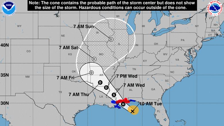
Hurricane Gordon hasn’t completely formed yet, but the weather system — which is currently a tropical storm — will be upgraded to a Category 1 hurricane before making landfall in Mississippi late Tuesday night.
The National Hurricane Center has issued a hurricane warning from the coast of Mississippi, to the the Alabama/Florida border. A hurricane warning means that hurricane-force winds (over 74 mph) are to be expected in the area. These winds will start later on tonight and will continue through the overnight hours.
Both the GFS & the Euro Models Show a Similar Track for Hurricane Gordon
Below is the latest GFS model, showing Gordon’s predicted track. As you can see, the GFS shows Gordon making landfall in Gulfport, Mississippi, before heading west northwest into Oklahoma and then turning east northeast by the end of the week.


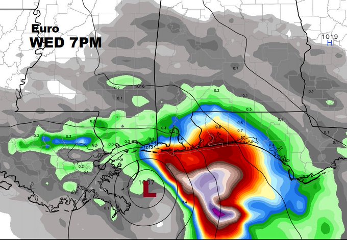
Below is the latest Euro model. At this time, the Euro and the GFS both show similar predicted paths.
“Gordon is forecast to be a Category 1 hurricane near the time it makes landfall on the northern Gulf Coast tonight most likely along the Mississippi Gulf Coast. Given a tropical cyclone’s strongest winds are usually are on its eastern side, that’s why the NHC issued a hurricane warning for parts of the Mississippi and Alabama coasts,” The Weather Channel reports.
Hurricane-Force Wind Gusts & Heavy Rain Expected in Parts of Florida, Mississippi & Alabama
The heaviest rain from Gordon will be from the northern Gulf Coast to parts of Arkansas, and will last through Thursday. Most areas will see somewhere between 4 to 8 inches of rainfall. It is possible to see upwards of 12 inches of rain in some areas. Localized flooding is possible.
As far as wind is concerned, those in Gordon’s path should expect tropical-storm-force winds, which can range from 39–73 mph, according to the Saffir-Simpson Scale. Hurricane-force gusts over 74 mph are possible. These winds can cause damage to roofs, and can cause tree branches to snap. Power outages are also possible, though they may not be widespread.
The National Hurricane Center says that a “few tornadoes are possible” near the coasts of Mississippi, Alabama, and the Florida Panhandle. That threat will begin this afternoon and last into overnight hours.