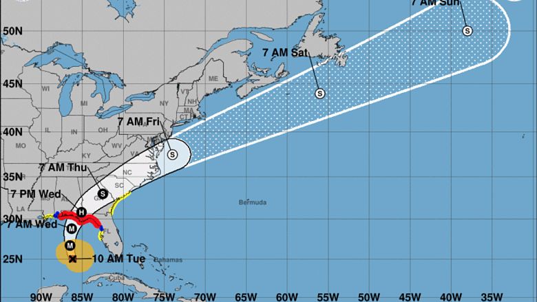
The latest European model shows Hurricane Michael tracking further west, which is good news for coastal communities on Florida’s west coast but doesn’t change the storm’s intensity. Michael is expected to make landfall in Florida’s panhandle on Wednesday as a Category 3 storm.
Michael is approximately 395 miles south of Panama City, Florida, and is moving north-northwest. A hurricane warning has been issued for the Florida Gulf coast from the Alabama/Florida border to Suwanee River, Florida, including Pensacola, Panama City, and Florida’s capital, Tallahassee.
The photo below shows the GFS model on the left and the Euro model on the right. Both models are fairly synced up at this point, showing Michael making landfall near Tallahassee.
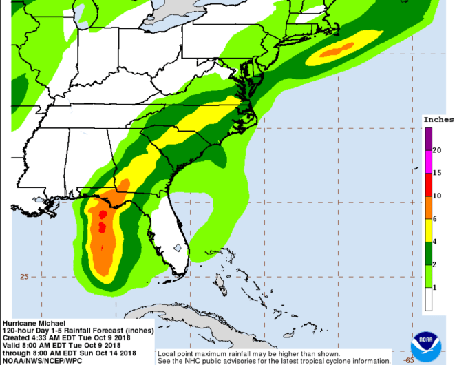
A Category 3 storm has sustained winds of 111-129 miles per hour. Heavy rain, storm surge, and downed trees and power lines are also expected. Some areas could see more than a foot of rain from Michael before the storm moves out.
Since the storm has shifted westward, the National Hurricane Center has adjusted its predictions in terms of rainfall across the state of Florida. While there had been increased chances of rain in cities like Naples and Tampa, the area isn’t expecting to see too much from Michael at all.

“Landfall is most likely to occur somewhere between the Florida Panhandle and the Big Bend of Florida a few hours either side of midday Wednesday. Conditions may begin to deteriorate as early as Tuesday evening on the northeastern Gulf Coast. After landfall, Michael will then accelerate inland across the southeastern U.S. Wednesday night through Thursday night with gusty winds and heavy rain,” The Weather Channel reports.
Florida Governor Rick Scott has issued a state of emergency for 35 counties. Additionally, 500 members of the Florida National Guard have been activated ahead of the storm.
“This storm will be life-threatening and extremely dangerous,” Scott said on Sunday.

