National Hurricane Center
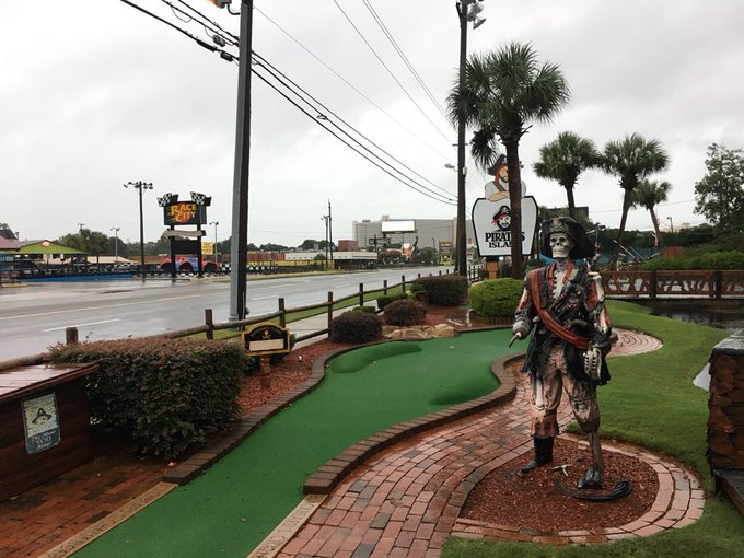
As Hurricane Michael heads toward the Florida panhandle, folks in Panama City Beach, Florida are bracing for impact. It’s expected that the storm will landfall there or near there. Watch live web cams of landfall here.
There are hurricane conditions forecast for October 10, 2018.
As of October 10, 2018, it was already too dangerous in Panama City Beach for emergency responders.
CNN’s @DianneG, live in Panama City Beach as Hurricane Michael approaches: “We have just been told Bay County Emergency Responders are at this point no longer going to be responding to calls because it is about to get too dangerous for them.”
Panama City beach
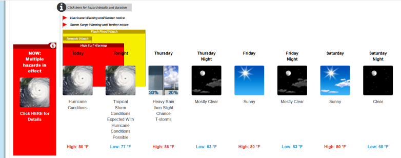
The forecast for the Tallahassee area for October 10 and October 11 reads, “Tropical Storm Conditions Expected With Hurricane Conditions Possible.” Landfall is expected in the morning to early afternoon of October 10. Here is the time prediction map for landfall:
Landfall will be be near PCB/Mexico beach area. However, life threatening storm surge, Hurricane force winds, and heavy rainfall is expected all along the northeastern Gulf Coast.
#Michael is steadily moving towards the coast, landfall is expected later this morning to early this afternoon. Conditions will deteriorate quickly, so stay put and find your safest location possible! #HurricaneMichael
#MichaelTLH 7:30 a.m. Update from Leon County EM Director Kevin Peters and NWS Tallahassee’s Lauren Nash
“Hurricane Michael is now a category 4 hurricane! Catastrophic storm surge and winds are expected today. Michael is expected to make landfall as a category 4 along the Florida Panhandle Coast or Big Bend late this morning or early afternoon. This is an unprecedented event as there are no Category 4 storms on record to have made landfall along the Florida Panhandle coast. There is an increasing threat for tornadoes this morning as rain bands are already moving onshore. Michael is expected to bring life-threatening storm surge, widespread power outages that will last days to even more than a week in some areas, downed trees that will block access to roads and endanger individuals, structural damage to homes and businesses, isolated flash flooding and the potential for tornadoes. Trees falling on homes will become a dangerous and potentially deadly situation. The time for preparations is quickly ending,” the National Weather Service wrote in its local impact statement for Tallahassee on October 10.
You can see the National Weather Service page for Tallahassee here.
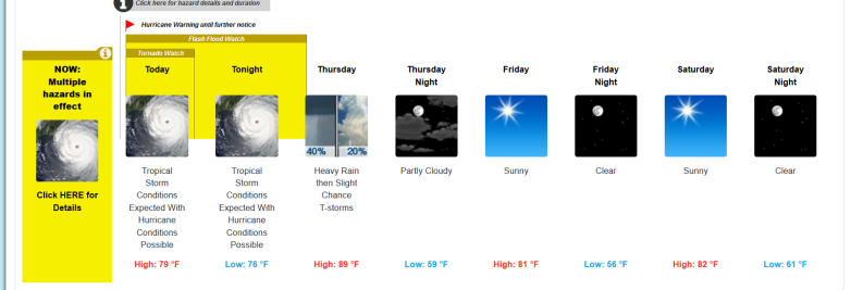
The detailed forecast for the Tallahassee area reads as follows from NWS:
“Today
Hurricane conditions. Showers and thunderstorms before 2pm, then showers and possibly a thunderstorm after 2pm. Some of the storms could produce heavy rain.
Tonight
Tropical storm conditions expected, with hurricane conditions possible. Showers and possibly a thunderstorm, mainly before 2am, then a chance of showers and thunderstorms after 2am. Some of the storms could produce heavy rainfall. Low around 77. Chance of precipitation is 100%. New rainfall amounts between three quarters and one inch possible.
Thursday
A 30 percent chance of showers and thunderstorms, mainly before 8am. Some of the storms could produce heavy rainfall. Mostly sunny, with a high near 86. Northwest wind around 15 mph.
Thursday Night
Mostly clear, with a low around 63. North northwest wind 10 to 15 mph.
Friday
Sunny, with a high near 80. North wind around 10 mph.
Friday Night
Mostly clear, with a low around 63.
Saturday
Sunny, with a high near 80.
Saturday Night
Clear, with a low around 68.
Sunday
Sunny, with a high near 84.
Sunday Night
Mostly clear, with a low around 73.
Monday
A 20 percent chance of showers and thunderstorms. Mostly sunny, with a high near 85.
Monday Night
A 20 percent chance of showers and thunderstorms. Mostly clear, with a low around 70.
Tuesday
A 20 percent chance of showers and thunderstorms. Sunny, with a high near 83.”
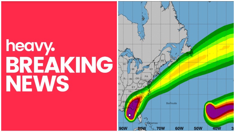
Spaghetti models provide a view of the storm’s track. The storm might become the strongest weather system to strike the panhandle in 13 years. As a result, many people are closely watching the hurricane’s path.
Cyclocane has a page that contains continuously updated spaghetti models for Hurricane Michael. You can access it here. The site also has a page with additional weather forecast information about Hurricane Michael that you can see here.
Hurricane Michael 2018 Projected Path 11 PM Update, Spaghetti Models #HurricaneMichael #Florida #Hurricane #Michael t.co/ZiDOcgucsc
NOAA is also a good place to check for updated Hurricane Michael spaghetti models and forecasts. Make sure you choose “Michael” via the storm ID tab on the top left of the page.
The South Florida Water Management District has a page of updated spaghetti models for hurricanes, including Michael. You can access all of the page’s hurricane model plots here. Choose “storm 14.”
National Weather Service General Information for Hurricane Michael
#Michael continues to strengthen, and Storm Surge and Hurricane Warnings are in effect for portions of the Florida Gulf Coast. Here are the 10 AM CDT Key Messages for #Michael t.co/tW4KeGdBFb

The National Weather Service provides extremely detailed weather forecast, models, and radar for Hurricane Michael broken down by locality.
You can find the National Hurricane Center’s hurricane page here, which includes information about Hurricane Michael.
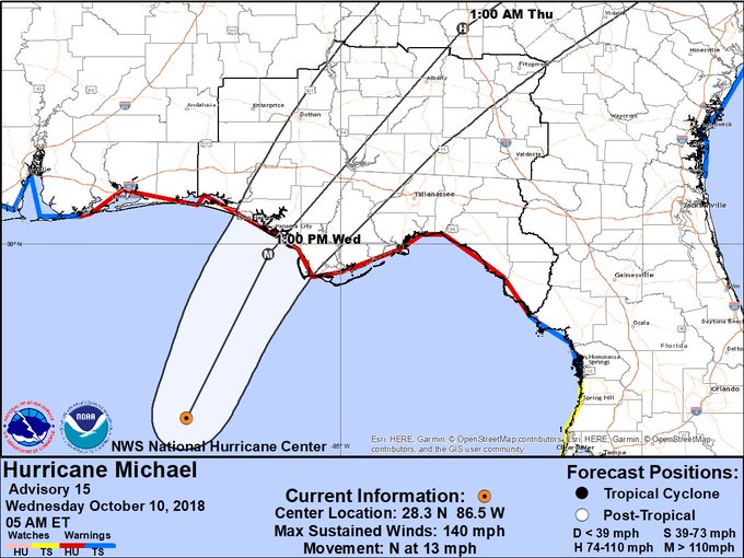
On the morning of October 10, 2018, the NWS offered this hurricane update:
“At 700 AM CDT (1200 UTC), the eye of Hurricane Michael was located
near latitude 29.0 North, longitude 86.3 West. Michael is moving
toward the north near 13 mph (20 km/h). A turn toward the north-
northeast is expected later this morning, with a turn toward the
northeast expected this afternoon or tonight. A motion toward the
northeast at a faster forward speed is forecast on Thursday and
Friday. On the forecast track, the eye of Michael is expected to
move ashore over the Florida Panhandle later today, move
northeastward across the southeastern United States tonight and
Thursday, and then move off the Mid-Atlantic coast away from the
United States on Friday.
Reports from an Air Force Reserve Hurricane Hunter aircraft
indicate that maximum sustained winds have increased to near 145 mph
(230 km/h) with higher gusts. Michael is an extremely dangerous
category 4 hurricane on the Saffir-Simpson Hurricane Wind Scale.
Some additional strengthening is possible before landfall. After
landfall, Michael should weaken as it crosses the southeastern
United States.
Hurricane-force winds extend outward up to 45 miles (75 km) from
the center and tropical-storm-force winds extend outward up to 185
miles (295 km). A wind gust to 56 mph (91 km/h) was recently
reported at Apalachicola Regional Airport.
The estimated minimum central pressure based on NOAA and Air Force
Reserve Hunter aircraft data is 933 mb (27.55 inches).”