As Hurricane Michael heads toward the Florida panhandle, folks in Tallahassee, Florida are wondering when and if the storm may hit their community. As of October 9, 2018, there was a hurricane warning for Tallahassee.
According to the National Weather Service, “A potentially catastrophic event is developing. Hurricane Michael, now with maximum sustained winds of 110 MPH, is forecast to continue to strengthen as it moves toward the northern Gulf coast.”
NWS continued: “Michael is forecast to reach major hurricane status this evening before landfall along the Florida Panhandle tomorrow. Michael is forecast to bring significant impacts to the area including life-threatening storm surge, widespread power outages, downed trees that will block access to roads and endanger individuals, structural damage to homes and businesses, isolated flash flooding and the potential for tornadoes. Impacts, including storm surge and tornadoes, may begin tonight along our coastline.”
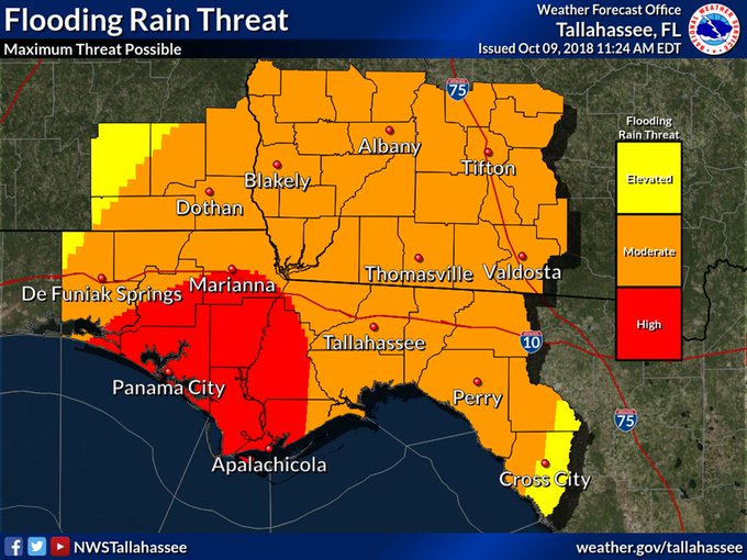
NWS is warning of dangerous winds, writing, “Protect against life-threatening wind having possible devastating impacts across the Florida panhandle, western Big Bend, extreme southwest Georgia, and extreme southeast Alabama.” Storm surge is also a concern. “Protect against life-threatening surge having possible devastating impacts across the Big Bend coast, especially Apalachee Bay,” NWS wrote. Flooding rain and tornadoes are also possible.
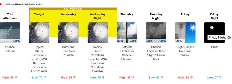
You can see the National Weather Service page for Tallahassee here. It projects that tropical storm conditions are possible the night of Tuesday, October 9, 2018, with hurricane conditions possible. Hurricane conditions are possible Wednesday and Wednesday night also. As of noon on October 9, 2018, here was the weather forecast for Tallahassee, Florida:

The detailed forecast for the Tallahassee area reads as follows from NWS:
“This Afternoon (October 9, 2018)
A 50 percent chance of showers and thunderstorms. Mostly cloudy, with a high near 86. East wind around 15 mph. New rainfall amounts of less than a tenth of an inch, except higher amounts possible in thunderstorms.
Tonight
Tropical storm conditions possible, with hurricane conditions also possible. A 50 percent chance of showers and thunderstorms. Mostly cloudy, with a low around 77. New rainfall amounts between a tenth and quarter of an inch, except higher amounts possible in thunderstorms.
Wednesday
Hurricane conditions possible. Showers and thunderstorms, mainly after 9am. High near 85. Chance of precipitation is 100%. New rainfall amounts between 3 and 4 inches possible.
Wednesday Night
Tropical storm conditions expected, with hurricane conditions possible. Showers and thunderstorms. Low around 76. Chance of precipitation is 100%.
Thursday
Showers and thunderstorms likely, mainly before 9am. Partly sunny, with a high near 87. South southwest wind 5 to 10 mph becoming west in the afternoon. Chance of precipitation is 60%.
Thursday Night
A chance of showers and thunderstorms before 9pm, then a slight chance of rain after 9pm. Mostly clear, with a low around 63. Chance of precipitation is 50%.
Friday
A 20 percent chance of rain before 9am. Sunny, with a high near 83.
Friday Night
Clear, with a low around 57.
Saturday
Sunny, with a high near 85.
Saturday Night
Mostly clear, with a low around 64.
Sunday
A 20 percent chance of showers and thunderstorms. Mostly sunny, with a high near 87.
Sunday Night
A 20 percent chance of showers and thunderstorms. Partly cloudy, with a low around 68.
Monday
A 20 percent chance of showers and thunderstorms. Mostly sunny, with a high near 86.”
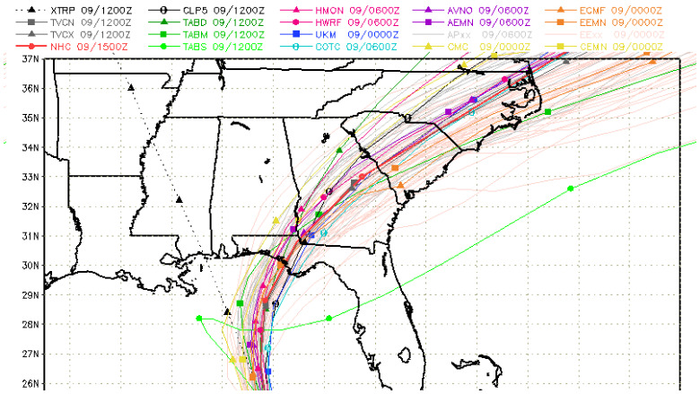
Spaghetti models provide a view of the storm’s track. The storm might become the strongest weather system to strike the panhandle in 13 years. As a result, many people are closely watching the hurricane’s path.
Cyclocane has a page that contains continuously updated spaghetti models for Hurricane Michael. You can access it here. The site also has a page with additional weather forecast information about Hurricane Michael that you can see here.
NOAA is also a good place to check for updated Hurricane Michael spaghetti models and forecasts. Make sure you choose “Michael” via the storm ID tab on the top left of the page.
The South Florida Water Management District has a page of updated spaghetti models for hurricanes, including Michael. You can access all of the page’s hurricane model plots here. Choose “storm 14.”
National Weather Service General Information for Hurricane Michael
The National Weather Service provides extremely detailed weather forecast, models, and radar for Hurricane Michael broken down by locality.
You can find the National Hurricane Center’s hurricane page here, which includes information about Hurricane Michael.
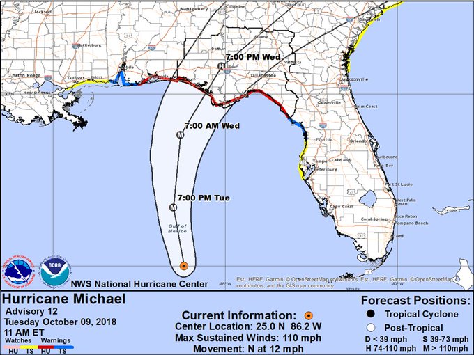
On the morning of October 9, 2018, the forecast for Hurricane Michael from NWS read as follows:
At 1000 AM CDT (1500 UTC), the eye of Hurricane Michael was located near latitude 25.0 North, longitude 86.2 West. Michael is moving toward the north near 12 mph (19 km/h). A northward motion is expected through tonight, followed by a northeastward motion on Wednesday and Thursday. On the forecast track, the center of Michael will move across the eastern Gulf of Mexico through tonight. The center of Michael is then expected to move inland over the Florida Panhandle or Florida Big Bend area on Wednesday, and then move northeastward across the southeastern United States Wednesday night and Thursday, and move off the Mid-Atlantic coast away from the United States by Friday.
Data from NOAA and Air Force Reserve Hurricane Hunter aircraft indicate that the maximum sustained winds have increased to near 110 mph (175 km/h) with higher gusts. Additional strengthening is expected, and Michael is forecast to be a major hurricane at landfall in Florida. Weakening is expected after landfall as Michael moves through the southeastern United States.
Hurricane-force winds extend outward up to 35 miles (55 km) from the center and tropical-storm-force winds extend outward up to 185 miles (295 km). NOAA buoy 42003 recently reported 1-minute mean winds of 45 mph (72 km/h) and a wind gust of 56 mph (91 km/h).
The latest minimum central pressure based on data from the aircraft is 965 mb (28.50 inches).


