
Some crazy clouds and a tornado warning for Columbia, Maryland as an intense storm passes through:
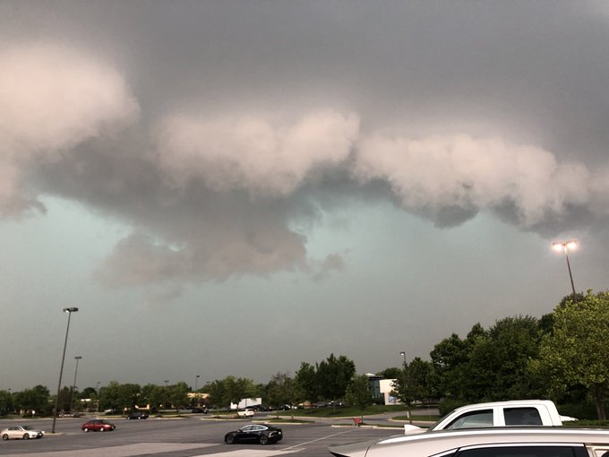
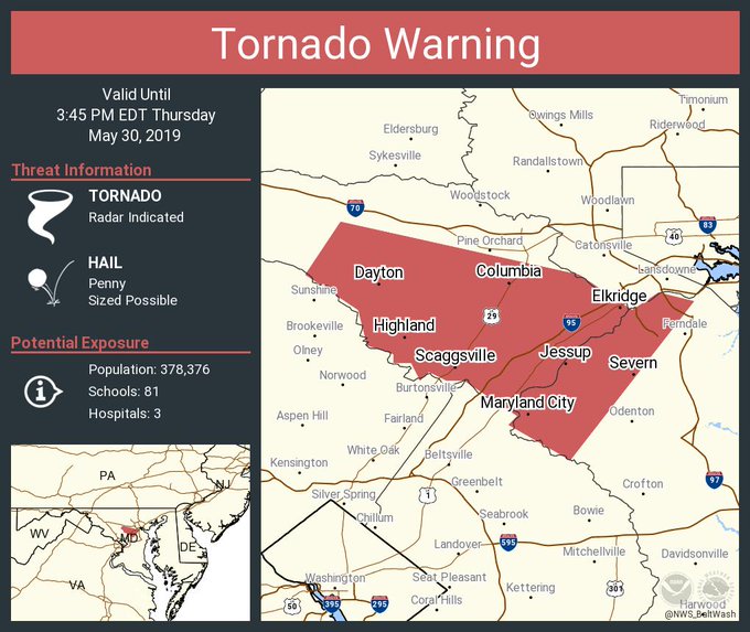
There is a tornado warning for Columbia, Maryland and other surrounding communities on May 30, 2019 – through 3:45 p.m. Photos captured the bad weather.

“Tornado Warning including Columbia MD, Severn MD, Scaggsville MD until 3:45 PM EDT,” the National Weather Service wrote. You can follow the Twitter page for the Baltimore/Washington D.C. office of the NWS here. It handles weather reports for Columbia, Maryland. The weather service then posted this update, “Severe Thunderstorm Warning including Baltimore MD, Columbia MD, Glen Burnie MD until 4:15 PM EDT.”
Tornado Warning including Columbia MD, Severn MD, Scaggsville MD until 3:45 PM EDT
Radar images captured the severe weather mass. Columbia, Maryland is located about 45 minutes from Baltimore.
The NWS issued a series of other tornado warnings and severe thunderstorm watches for the area. Here were some of the others posted on the afternoon of May 30:
“Severe Thunderstorm Warning including Washington DC, Arlington VA, Alexandria VA until 4:00 PM EDT.”
“Severe Thunderstorm Warning including Columbia MD, Ellicott City MD, Frederick MD until 3:45 PM EDT.”
“Severe Thunderstorm Warning including Warrenton VA, Marshall VA, Chester Gap VA until 3:30 PM EDT.”
A tornado warning for Frederick, Maryland expired.
You can see updated weather forecasts and radar reports for the region including Columbia, Maryland here.
“The National Weather Service in Sterling Virginia has issued a:
* Tornado Warning for…
Northwestern Anne Arundel County in central Maryland…Howard County in central Maryland…
* Until 345 PM EDT.
* At 321 PM EDT, a severe thunderstorm capable of producing a tornado was located 7 miles northeast of Olney, moving southeast at 40 mph.
HAZARD…Tornado.
SOURCE…Radar indicated rotation.
IMPACT…For those in the direct path of a tornado touchdown, flying debris will be dangerous to those caught without shelter. Damage to roofs, siding, and windows may occur. Mobile homes may be damaged or destroyed. Tree damage is likely.”
The extended forecast for the region is as follows, per the National Weather Service:
“This Afternoon (May 30)
Showers likely and possibly a thunderstorm. Some of the storms could produce small hail and gusty winds. Mostly cloudy, with a high near 85. Southwest wind around 9 mph. Chance of precipitation is 70%. New rainfall amounts between a quarter and half of an inch possible.
Tonight
Showers and thunderstorms likely before midnight, then a slight chance of showers between midnight and 2am. Some of the storms could produce small hail and gusty winds. Mostly cloudy, with a low around 63. West wind 7 to 10 mph. Chance of precipitation is 60%. New precipitation amounts between a tenth and quarter of an inch, except higher amounts possible in thunderstorms.
Friday
Mostly sunny, with a high near 82. West wind around 6 mph.
Friday Night
Partly cloudy, with a low around 61. Northwest wind around 5 mph becoming calm in the evening.
Saturday
A chance of showers and thunderstorms after 2pm. Sunny, with a high near 84. Calm wind becoming west around 5 mph in the afternoon. Chance of precipitation is 30%.
Saturday Night
A chance of showers and thunderstorms before 2am, then a slight chance of showers. Mostly cloudy, with a low around 63. Chance of precipitation is 30%.
Sunday
Showers likely, with thunderstorms also possible after 2pm. Partly sunny, with a high near 79. Chance of precipitation is 60%.”