NWS
Scranton, Pennsylvania was under a tornado warning for a period of time on the evening of May 28, 2019, as other states reeled from tornado damage. However, it expired at 7:15 p.m. EDT.
A tornado was spotted near Clark’s Summit. However, according to PennLive, the National Weather Service is letting the Scranton-area tornado warning expire at that time because “the storm that prompted the warning is no longer capable of producing a tornado and has left the area…” but “gusty winds and heavy rain are still possible within the storm.”
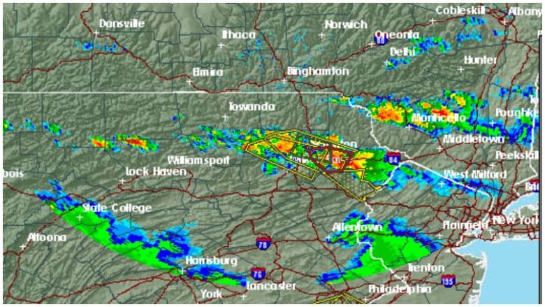
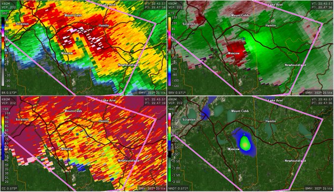
🚨 Radar data continues to show impressive rotation and a potential tornado with a tornadic supercell just to the east of Scranton, PA

Please be prepared to act quickly if you are within the tornado warning!
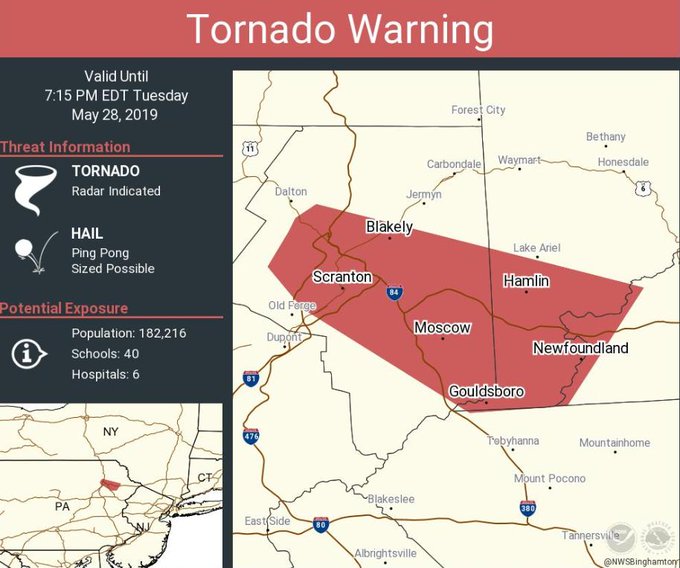
“Tornado Warning continues for Scranton PA, Dunmore PA, Blakely PA until 7:15 PM EDT,” wrote the National Weather Service’s Binghamton office, which serves the Scranton area. However, there is a severe thunderstorm warning for a bit longer in Scranton. “Severe Thunderstorm Warning including Scranton PA, Dunmore PA, Old Forge PA until 8:00 PM EDT,” the office wrote. (Western Pennsylvania counties were mostly under a tornado watch, not warning.)
See updated radar for Scranton here.
Tornado Warning continues for Scranton PA, Dunmore PA, Blakely PA until 7:15 PM EDT

In addition, wrote NWS Binghamton, Scranton, Pennsylvania was under a flash flood warning. “Flash Flood Warning including Scranton PA, Dunmore PA, Archbald PA until 9:45 PM EDT,” the NWS office wrote on its Twitter page. You can follow NWS Binghamton on Twitter here.

The Pennsylvania tornado scare occurred the day after several twisters caused severe damage in Ohio, especially in the Dayton area. One man lost his life and multiple injuries were reported. Tornadoes also caused severe damage in El Reno, Oklahoma and in Jefferson City, Missouri.
Here’s what you need to know:
The Extended Weather Forecast Predicts Severe Weather in Scranton
The weather forecast for the Wilkes-Barre and Scranton office can be found here. The latest reads as follows:
Tonight (May 28, 2019): “Showers and thunderstorms likely before 3am, then a slight chance of showers. Some storms could be severe, with large hail, hail, and damaging winds. Patchy fog after 3am. Otherwise, mostly cloudy, with a low around 59. Southwest wind 5 to 8 mph becoming northwest after midnight. Chance of precipitation is 70%. New rainfall amounts between a quarter and half of an inch possible.”
Here is the rest of the week’s forecast per NWS:
“Wednesday
A slight chance of showers before 3pm, then a chance of showers and thunderstorms between 3pm and 5pm, then showers likely and possibly a thunderstorm after 5pm. Patchy fog before 7am. Otherwise, partly sunny, with a high near 76. Light and variable wind becoming west around 6 mph in the afternoon. Chance of precipitation is 60%. New rainfall amounts between a tenth and quarter of an inch, except higher amounts possible in thunderstorms.
Wednesday Night
Showers likely and possibly a thunderstorm before 8pm, then a chance of showers and thunderstorms between 8pm and 3am, then a chance of showers after 3am. Mostly cloudy, with a low around 62. Light west wind. Chance of precipitation is 60%. New rainfall amounts between a tenth and quarter of an inch, except higher amounts possible in thunderstorms.
Thursday
A chance of showers before 8am, then a chance of showers and thunderstorms between 8am and 2pm, then showers likely and possibly a thunderstorm after 2pm. Mostly cloudy, with a high near 78. Calm wind becoming northwest 5 to 7 mph in the afternoon. Chance of precipitation is 60%. New rainfall amounts between a tenth and quarter of an inch, except higher amounts possible in thunderstorms.
Thursday Night
Showers likely, mainly before 8pm. Mostly cloudy, with a low around 57. Southeast wind 5 to 11 mph becoming northwest after midnight. Chance of precipitation is 60%.
Friday
Mostly sunny, with a high near 73.
Friday Night
Mostly clear, with a low around 51.
Saturday
Sunny, with a high near 78.
Saturday Night
Partly cloudy, with a low around 57.
Sunday
A chance of showers. Partly sunny, with a high near 74. Chance of precipitation is 40%.
Sunday Night
A chance of showers. Partly cloudy, with a low around 52. Chance of precipitation is 30%.
Monday
Mostly sunny, with a high near 69.
Monday Night
Partly cloudy, with a low around 49.
Tuesday
Sunny, with a high near 71.”