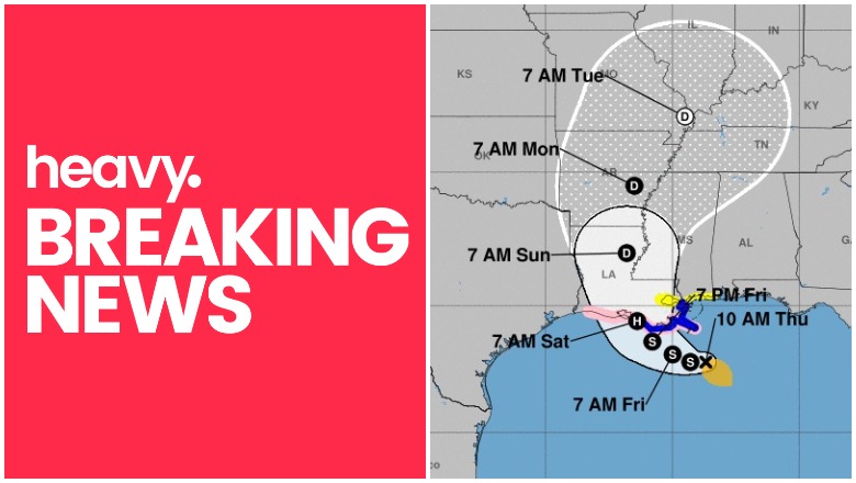
NOAA Tropical Storm Barry
Tropical Storm Barry has recently formed in the Gulf and appears to be heading to Louisiana, which has already experienced a lot of flooding. Some forecasts expect it to be a hurricane by the time it hits the coast. The National Hurricane Center is providing frequent updates about the storm’s movements. Here are details from the latest update from the NOAA as of Thursday, July 11 at 10 a.m. Central The next complete advisory will be at 4 p.m. Central. You can read the full updates on the NOAA’s website here.
Tropical Storm Barry’s Location, Coordinates & Movement
As of 10 a.m. Central, Barry was located at 27.8 N, 88.7 W, about 95 miles south-southeast of the mouth of the Mississippi River, according to NOAA. It was about 200 miles southeast of Morgan City, Louisiana.
The storm is moving west or 270 degrees at 5 mph.
The National Hurricane Center noted the following at 10 a.m. “Barry is moving toward the west near 5 mph (7 km/h) and this motion is expected to continue today. A turn toward the west-northwest is expected tonight, followed by a turn toward the northwest on Friday. On the forecast track the center of Barry will be near the central or southeastern coast of Louisiana Friday night or Saturday.”
Tropical Storm Barry’s Wind Strength, Pressure, & Rainfall
The storm’s maximum sustained winds as of 10 a.m. are 40 mph. The minimum central pressure is 1005 MB (29.68 inches) according to NOAA. Additional strengthening is expected over the next day or two, with Barry possibly becoming a hurricane by late Friday or early Saturday.
Tropical storm winds extend 90 miles, mostly to the southeast.
Rainfall is expected to be 10 to 15 inches, with some isolated areas up to 20 inches across eastern Louisiana and southern Mississippi.
Current Watches & Warnings
According to the National Hurricane Center, the following warnings and watches are in effect.
Hurricane Watch
- Mouth of the Mississippi River to Cameron
Tropical Storm Warning
- Mouth of the Pearl River to Morgan City
Tropical Storm Watch
- The Mississippi coast from east of the mouth of the Pearl River to the Mississippi/Alabama border.
- Lake Pontchartrain and Lake Maurepas, including metropolitan New Orleans
Storm Surge Warning
- The Louisiana coast from the mouth of the Atchafalaya River to Shell Beach.
Storm Surge Watch
- Mississippi coast from the mouth of the Pearl River to the Mississippi/Alabama border.
- Shell Beach to the Mississippi/Alabama border
- Mouth of the Atchafalaya River to Intracoastal City
Additional watches and warnings may be issued, so stay tuned to local news for updates in your region.
Additional Hurricane Discussions
The NOAA’s 10 a.m. updated included some additional details worth noting.
“The initial motion is a rather uncertain 270/4. Barry is being steered by a weak low- to mid-level ridge to the north, and a weakness in the ridge is forecast to develop during the next 24-48 h. This should allow the cyclone to turn northwestward and eventually northward. However, there is a large spread in the track guidance. The HWRF and HMON forecast Barry to move almost due north from its current position with a landfall in Mississippi, while the UKMET takes the cyclone to the upper Texas coast. The GFS, ECMWF, and Canadian models lie between these extremes. Overall, there has been a slight eastward shift of the guidance envelope, so the new forecast track is also adjusted slightly to the east. It should be noted, though, that the new track is west of the consensus models.”