NOAA Tropical Storm Barry
The National Hurricane Center has released new updates about Tropical Storm Barry as of 7 p.m. Central on July 11, 2019. These updates include new watch and warning areas, along with new predictions for the storm that has formed in the Gulf and is slowly moving toward Louisiana. You can read the full updates on the NOAA’s website here. Here’s a summary of the latest updates for July 11.
Tropical Storm Barry’s Location, Coordinates & Movement as of 7 p.m. on July 11
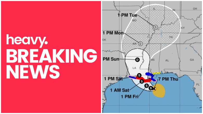
As of 7 p.m. Central, Barry was located at 27.8 N, 89.3 W, about 90 miles south of the mouth of the Mississippi River, according to NOAA. It was about 175 miles southeast of Morgan City, Louisiana.
The storm is moving west or 270 degrees at 3 mph, which is a couple miles per hour slower than this morning.
The National Hurricane Center noted the following at 7 p.m.: “Barry has moved little over the past few hours, but a motion toward the west near 3 mph (5 km/h) is expected to resume later tonight. A turn toward the northwest is expected on Friday, followed by a turn
toward the north on Saturday. On the forecast track, the center of Barry will be near or over the central or southeastern coast of Louisiana Friday night or Saturday, and then move inland into the lower Mississippi Valley on Sunday.”
According to NOAA, hurricane conditions are expected in the Hurricane Warning area by Friday night or Saturday morning. Tropical storm conditions could be felt by Friday morning. Within the Hurricane Watch area, regions could feel hurricane conditions by Friday night or Saturday morning.

A few tornadoes may be possible by late morning Friday through Friday night in southeast Louisiana, far southern Mississippi, and the Alabama coast, NHC warned.
Tropical Storm Barry’s Wind Strength, Pressure, & Rainfall
The storm’s maximum sustained winds as of 7 p.m. are 45 mph, which is a slight strengthening of 5 mph from this morning. The minimum central pressure is 1001 MB (29.56 inches) according to NOAA. Additional strengthening is expected, with Barry possibly becoming a hurricane by late Friday or early Saturday.
Tropical storm winds extend 140 miles from the center, up from 90 miles from the center this morning.
Rainfall is expected to be 10 to 20 inches over the region of southeast Louisiana and southwest Mississippi, NOAA noted. Some isolated areas could see as much as 25 inches. Other areas in the Lower Mississippi Valley might see 4 to 8 inches, with isolated areas up to 12 inches.
Current Watches & Warnings
According to the National Hurricane Center, the following warnings and watches are in effect as of 7 p.m. Central.
Hurricane Warning
- Coast of Louisiana from Intracoastal City to Grand Isle
Hurricane Watch
- Mouth of the Mississippi River to Grand Isle
- Intracoastal City to Cameron
Tropical Storm Warning
- Mouth of the Pearl River to Grand Isle
- Lake Pontchartrain and Lake Maurepas, including metropolitan New Orleans
- The Louisiana coast from Intracoastal City to Cameron
Tropical Storm Watch
- East of the mouth of the Pearl River to the Mississippi/Alabama border
Storm Surge Warning
- Mouth of the Atchafalaya River to Shell Beach
Storm Surge Watch
- Shell Beach to the Mississippi/Alabama border
- Mouth of the Atchafalaya River to Intracoastal City
- Lake Pontchartrain
Additional watches and warnings may be issued, so stay tuned to local news for updates in your region.
Additional Hurricane Discussions
The NOAA’s 7 p.m. updated included some additional details worth noting.
“Barry has become a little better organized since the last advisory, with a convective band forming closer to the center in the southern semicircle and the central pressure falling to near 1003 mb. However, the strongest winds are still 70 nm or more from the center, and there are several cloud swirls rotating around the mean center. The initial intensity remains 35 kt based on earlier aircraft and scatterometer data, but it is possible this is a little conservative.”
You can read more here.