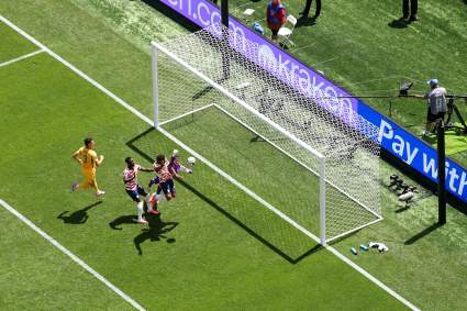
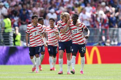
California Fire Map: Track Fires Near Me Right Now [August 19]

California fire

Inciweb California fire

Fires continue to burn in California. Here’s a look at the latest wildfires being reported on August 19 2019. This article first includes interactive maps for all of California, including Cal Fire and other sources. Then the second section details specific fires in the region in alphabetical order. Remember that when it comes to fires, details can change quickly, so also stay tuned to your local news sources if there is a fire in your region.


Interactive Maps of California Fires

There are two interactive maps to follow to get the best updates about California fires this summer. In many cases, the fires don’t always overlap so it’s good to review all the maps for the latest information.

One of the best interactive maps available right now is Inciweb’s map. You can see the full map here. There’s an embeddable Google Map that includes Inciweb fires which you can see below. Depending on your browser, you may need to zoom in using the + button within the map or change settings on the Layers tab of Legend to only show Inciweb fires:

Another good map can be found here from Ca.gov. A screenshot is below since the map can’t be embedded, but you’ll want to go to the full map for details. You can input your address to see how close the fires are to your location.

Ca.gov

Each of these maps often contains details the others are missing, so you’ll need to view all three for a full update on the fires. However, brand new fires may not be listed on any of the above maps until they’ve been around for a few hours.

(Note: A previously helpful map was provided by CAL FIRE and Google. Unfortunately, this map hasn’t been updated in a while, so we’re no longer embedding the map in the story.)

Next are more specific details on the fires for August 19, 2019. If you are looking for a specific fire, search for the name so you can find it faster, or just scroll down and look at the fires, listed in alphabetical order.


List of Active Fires in California on August 19, 2019

Here are the active fires and updates about them. Most of these are in alphabetical order.

Atascadero Fire

This fire isn’t officially named, but it’s near Atascadero and started on August 19 off Highway 101. The fire started when a semi truck in the southbound lane of Highway 101 burst into flames and then the fire spread to nearby vegetation, KSBY reported. Southbound traffic was diverted, but one southbound lane has since reopened this afternoon. Forward progress was stopped after the fire grew to 3/4 acre. The fire is 100 percent contained.

Broder Fire

This fire is 97 acres in size and was started by lightning on August 8. It’s northeast of Broder Meadow and crews are using natural barriers to fight the fire. Smoke may impact areas nearby, Inciweb noted. Smoke may be seen in Kennedy Meadows and Kernville. So far there are no road or trail closures.

Dixon Fire

This fire is nine acres in size and was caused by lightning. It’s east of Silver Peak on Carson Iceberg Wilderness, Inciweb reported.

Inciweb noted on August 14, which is the last update: “Humboldt-Toiyabe National Forest fire managers continue to make use of a lightning-caused fire to meet multiple resource objectives in the Carson-Iceberg Wilderness. The Dixon Fire is located east of Silver Peak on the north side of Dixon Creek and was discovered on July 28 by aerial reconnaissance after storms passed through the area. The Dixon fire remains deep in the Wilderness and is being managed for the following multiple objectives: reducing accumulated forest fuels, reintroducing fire into the ecosystem, ensuring firefighter and public safety, and decreasing the risk of future catastrophic fires in the area. The fire has seen minimal growth over the last week, remains approximately nine acres in size, and continues to burn at a low intensity.”

Gaines Fire

CA.gov

This fire is 1,300 acres and 75 percent contained as of August 19. It’s in Mariposa County, located at Mt. Gaines Road and Bear Valley Road in Bear Valley, according to Ca.gov. The cause is under investigation.

According to Ca.gov, there is an evacuation advisory for Bear Valley, Pendola Garden Road and Highway 49.

June Lightning Fires 2019 (Bald Fire and Lost Fire)

Inciweb

In Kernville, California, two fires were discovered in the Sequoia National Forest from lightning, Inciweb wrote. These are the Bald Fire and the Lost Fire. Together they have burned about 122 acres as of July 16. The good news is that as of July 23, both fires are 100 percent contained at 122 acres.

Mill Fire

This fire in Monterey County is 310 acres and 100 percent contained as of August 13. It was in Los Padres National Forest, west of Fort Hunter Liggett, according to Ca.gov.

The cause is being investigated.

SHF Lightning 2019

As of August 19, all 35 lightning fires from the August 8-10 event are under control or have been declared out. No more updates will be issued unless something significant changes, Inciweb noted. Here are the details for August 19: 

Trinity River Management Unit (Weaverville, Big Bar, Trinity Lake, Trinity Alps)

08/10/2019 19:11, MONTGOMERY, Montgomery Ridge near Hwy 3 0.1 acre, Out
08/10/2019 07:21, TANGLE, Tangle Blue Creek and Hwy 3, 0.1 acre, Out
08/11/2019 12:51, STONEY, Stoney Point Trinity Lake, 0.1 acre, Out
08/12/2019 13:22, SUNFLOWER, Near Sunflower Creek, 0.5 acre, Out
08/12/2019 15:00, SHERER, S of Sherer Ridge, 0.71 acre, Contained
08/12/2019 15:00, BARNUM, Near Big French Creek, 1.7 acres, Controlled
08/12/2019 16:00, PANSY, Near Swift Creek, 0.75 acres, Out
08/12/2019 16:00, BUSHY, Granite Peak Rd, .75 acres, Out
08/13/2019 16:00, COFFEE, Near Billy’ Peak, 0.1 acre, Out
08/13/2019 16:06, RIDGE, NE of Sunflower Flat, 0.1 acre, Controlled

Shasta Lake Ranger District and the National Recreation Area (Shasta Lake)

08/10/2019 09:15, DONEY, NW of Lakehead, 0.1 acre, Out
08/10/2019 11:21, DOOLES, N of Salt Creek Mtn, 0.1 acre, Out
08/10/2019 10:41, SPRING, Across canyon from Prospect Creek, 0.1 acre, Out
08/10/2019 11:24, SALT, N of Salt Creek Mtn, 0.1 acre, Out
08/10/2019 19:00, CHARLIE, NW of Lakeshore East, 0.1 acre, Out
08/10/2019 09:57, PROSPECT, W of Shoeinhorse Mtn, 0.1 acre, Out
08/10/2019 07:14, BRUSHY, Near Brushy Canyon, 0.25 acre, Out
08/10/2019 09:57, HAPPY, Happy Hunting Grounds, 0.1 acre, Out
08/10/2019 17:58, HUNTING, W of Iron Canyon Reservoir, 0.1 acre, Out
08/11/2019,12:45, HOOVER, Squaw Arm Shasta Lake, 0.5 acre, Out
08/11/2019 10:44, MUDDY, East side of Garden Ridge, 3.5 acres, Out

Shasta McCloud Management Unit (Mt Shasta and McCloud area)

08/10/2019 11:28, ZOT, Near Hazel Creek Rd, 0.1 acre, Out
08/10/2019 13:15, TOAD, E of Toad Mtn, 0.1 acre, Out
08/10/2019 16:41, CINDER, E of Hotlum near Cinder Cone, 0.1 acre, Out
08/10/2019 16:16, BEAR, N of Gumboot Lake, 0.1 acre, Out
08/10/2019 19:25, FISCHER, Across from Sims Flat, 0.1 acre, Out
08/10/2019 12:13, SISSON, Rocky high elevation on Mt Eddy, 0.1 acre, Out
08/10/2019 16:17, WHITE, N of Bear Ridge, S of 0.1 acre, Out
08/10/2019 15:53, FRENCH, W of Sugarloaf 0.1 acre, Out
08/10/2019 20:01, PICAYUNE, W of Porcupine Lake, 0.1 acre, Out
08/12/2019 16:54, GAZELLE, Near Dewey Mine, 0.1 acre, Out
08/13/2019 16:46, CRATER, Near Harris Mtn, 0.1 acre, Out
08/12/2019 17:30, TRINITY, NE of Sherer Ridge, 5.5 acres, Out
08/16/2019 09:37, NORTHGATE, Northgate gate trail head on Mt Shasta, 0.1 acre, Out

Springs Fire

InciwebSprings Fire Map

This fire is now 2,177 acres and 27 percent contained, according to Inciweb on August 18, the latest update. It was caused by lightning. It’s located 13 miles southeast of Lee Vining. Moderate fire activity is expected over the next 72 hours. The map above is from August 19.

On August 19, Inciweb noted: “Firefighters are holding containment lines and will continue to tactically apply fire to bring it to containment lines. The Springs Fire containment strategy includes reintroducing fire into the landscape in its’ natural role. Smoke emissions are expected to decline this week, air quality is anticipated to remain in the good (green) range. Moderate (yellow) smoke levels will become less likely. Winds will be light and variable and light smoke and haze may remain over the fire area late evenings and early mornings.” 

Ward Fire

Ca.gov

This fire is in Oregon but near the border with California. It’s currently 1,301 acres and 78 percent contained as of August 16, the latest update from Ca.gov and Inciweb. The cause is under investigation. The fire started August 9 and is near Highway 66 and Ward Road, about 13 miles west of Keno, Oregon. It’s also 18 miles southwest of Klamath Falls.

You can follow updates on the fire’s Facebook page, but it will only be updated if something new happens to the fire. For now, the page has closed down.

READ NEXT: WATCH: Man with TV on Head Leaves CRT TVs on Porches in Virginia