Inciweb
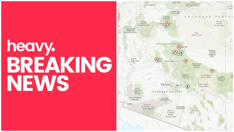
Fires continue to cause issues in Arizona in September. Read on for details about the fires, their locations, containment size, maps, and more. As news can change quickly, be sure to watch your local news for the latest evacuation details.
Interactive Maps of Arizona Fires
One of the best interactive maps available right now is Inciweb’s map. You can see the full map here. There’s an embeddable Google Map that includes Inciweb fires which you can see below in Arizona. Depending on your browser, you may need to zoom in using the + button within the map or change settings to only show Inciweb fires:
You can also see an interactive fire map for the Arizona area, provided by NWCG.gov. An embedded version is below, but click on the link to see a full version.

Here are the fires currently in Arizona as of September 15, 2019. Some of them are prescribed fires that are set purposefully by officials to help prevent bigger wildfires from starting and spreading. Others are wildfires that you’ll want to keep a closer eye on.
Eden Fire
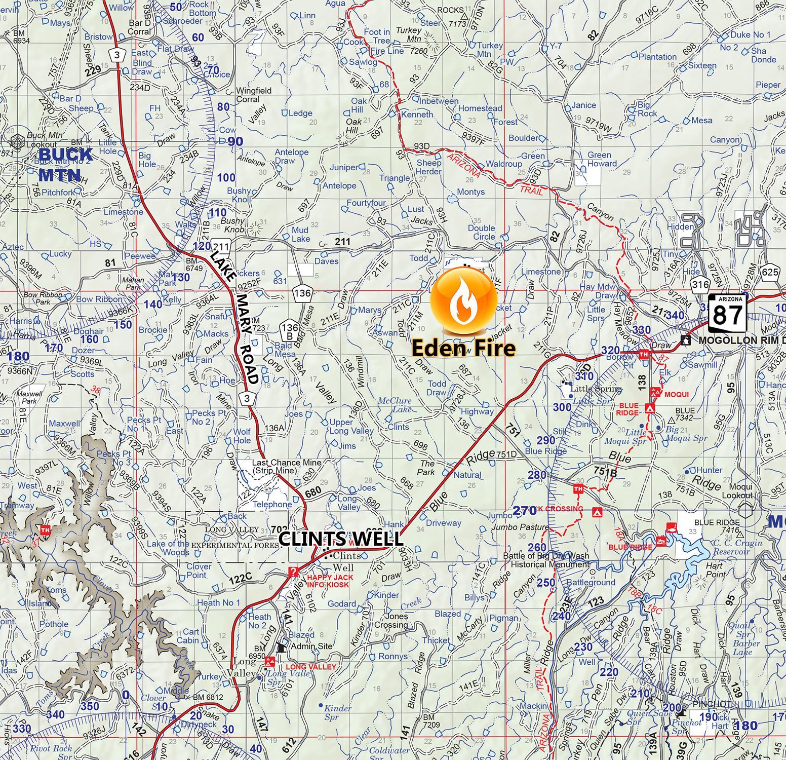
Inciweb
This fire is 1,750 acres and 30 percent contained as of September 12, the latest Inciweb update. It was caused by lightning and is located at FR211/FR211C Todd Draw in Lost Eden. It’s four miles northeast of Clints Well.
Inciweb noted, in part: “The fuel buildup is currently burning on steep slopes in the Lost Eden Tank area in Ponderosa Pine and grass understory within heavy dead and down trees, as well as standing dead trees. Firefighters have used burnout operations for the last several days to establish fire control lines away from the main fire. These standoff tactics are used to maximize successful restoration and minimize the risk to firefighters and public… Large amounts of smoke will be in the area over the next few weeks,as the fire continues to consume pockets of previously unburned forest fuels well within the established 19,885 acres fire boundary…. The public should use caution when recreating or hunting near the fire area due to hazardous fire-weakened trees, burning stump holes and fire personnel working in the area.”
Ikes Fire
As of September 12, the latest Inciweb update, the fire is 7,650 acres. It was caused by lightning. Inciweb notes: “Fire crews will hold and patrol the perimeter of the fire planning area. Crews will mop up and repair fire suppression actions.”
The most recent Inciweb map is below.
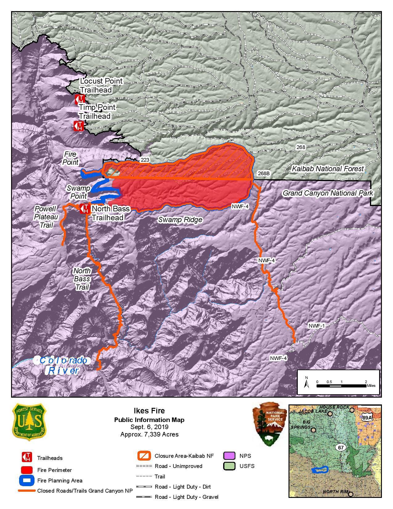
Inciweb
Inciweb also noted: “The lightning-caused fire is being utilized to fulfill its natural role in a fire-dependent ecosystem within a defined planning area of 7,785 acres on the Kaibab Plateau. The fire is being utilized to achieve a variety of resource objectives including reducing hazardous fuels, promoting forest regeneration, improving wildlife habitat, and restoring more open forest understory with grasses and forbs. Fire is a force of nature that has shaped the vegetation and ecosystems of Grand Canyon National Park.”
Museum Fire
This fire is now 100 percent contained at 1,961 acres, although some maps still list it as active.
Sheridan Fire
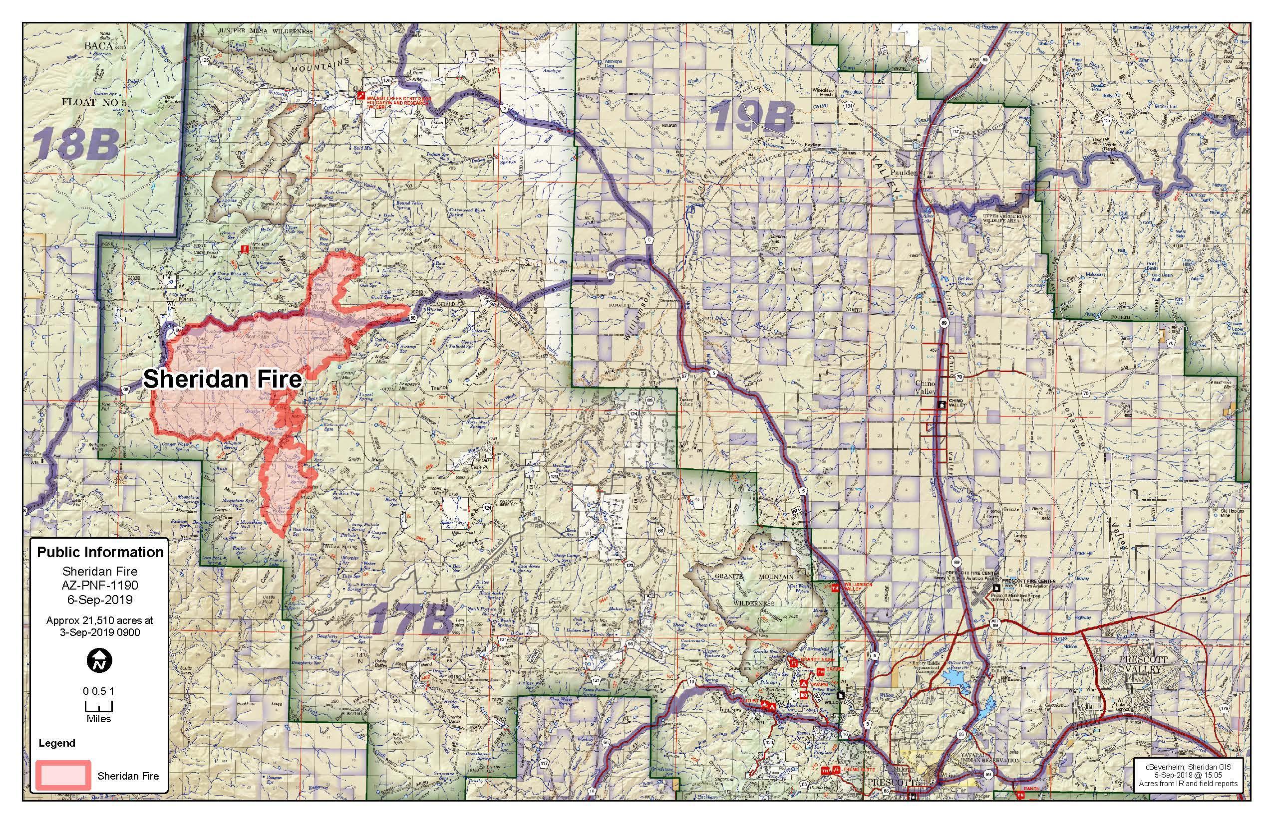
Inciweb
This fire is 21,510 acres and 60 percent contained as of September 6, the last Inciweb update. It’s in Wood Trap Area, 20 miles northwest of Prescott, Arizona. Decreased fire activity means that regular updates will no longer be issued by Inciweb.
Inciweb notes: “The Sheridan Fire is a lightning-caused wildfire that continues to fulfill its natural role while firefighters continue to provide for point protection of cultural and natural resources. Utilizing the lightning-caused fire for resource benefit will improve wildlife habitat and restore more open forest understory with grasses and forbs.”
Telephone Fire
This fire is 350 acres as of September 8, the latest Inciweb update. It was caused by lightning and is located in the Lake Mountain region. The status of this fire is simply to hold and monitor it.
Whiskey Fire
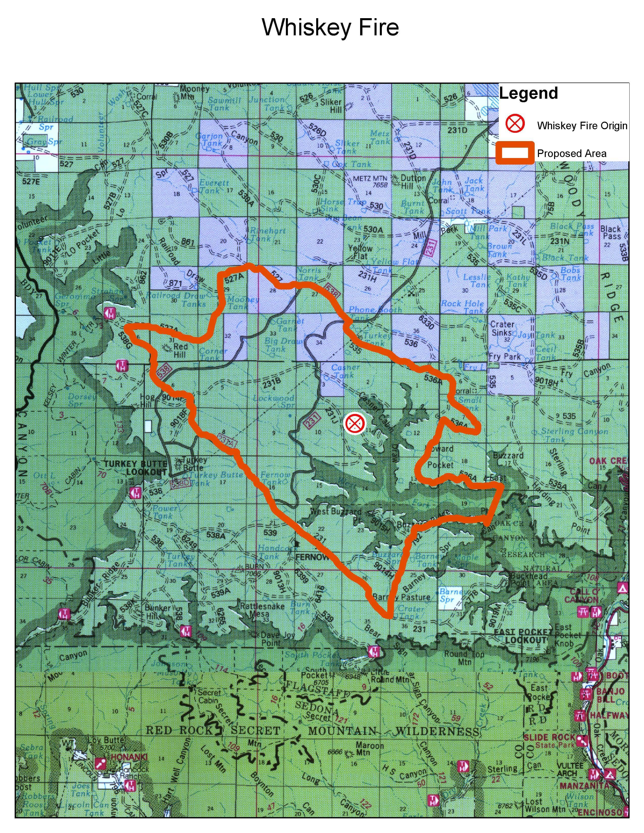
Inciweb
This fire is the biggest concern right now. As of September 14 it’s 3,872 acres and 16 percent contained. It’s located south of Casner Cabin Draw and east of FS Road 231J. It was started by lightning. It’s eight miles east of Turkey Butte Lookout.
Inciweb noted:
“On Thursday, firefighters conducted a large firing operation. This operation was vital to secure control lines and keep the fire within its containment area. This firing operation produced a great deal of smoke in the area. Due to an atypical wind shift, smoke from the fire was pushed south to the areas of Prescott Valley, Camp Verde, Chino Valley and other areas south and southwest of the fire area. Yesterday, fire personel moderated firing operations in efforts to minimize smoke impacts to the surrounding areas, allowing only areas of unburned fuel to continue to burn within the fire perimeter.
Today, firefighters will continue to utilize similar tactics as the previous operational period. Moderating firing operations allowing only areas of unburned fuel within the fire perimeter to burn. Fire personel will continue to reinforce control lines and ensure that the fire stays within control lines.
Fire personnel will moderate firing operations through the weekend to reduce smoke impacts to the area. However, no perfect weather condition exist to remove smoke impacts entirely from a fire. Smoke is expected spread to the north over the next several days following a more seasonal south west wind pattern. Smoke may affect areas including Flagstaff, Munds Park, Mountainaire, Kachina Village, Forest Highlands, Doney Park, Mormon Lake Village, Highway 89A Corridor, Sedona, Village of Oak Creek and portions of Interstate 40.”
The following closures are in place, per Inciweb on September 14: “Forest Road 231 is closed at the intersection of FR 536 (near Phone Booth Tank) all the way south to the intersection of FR 231A. The closure may last through the weekend in efforts to provide for firefighter and public safety. However, the closure could last longer if necessary to safely continue vital operations. Persons planning to travel in this area should expect delays and use the alternate routes identified at closure points. (The alternate route will be at Phone Booth Tank, follow FR 538 west to FR 538D, to FR 231A to reconnect to FR 231 South of the fire area).”
Smoke from this fire can be seen in areas such as Flagstaff, Munds Park, SR 89A Corridor, Sedona, Village of Oak Creek, and I-40, according to Coconino National Forest.