NWS Will Hurricane Dorian hit West Palm Beach?
West Palm Beach is bracing for monster storm Hurricane Dorian, but will the weather system strike that community? It’s always possible, but the latest forecast shows the hurricane’s path taking a slightly more favorable turn for Floridians and those in West Palm Beach.
According to the National Weather Service forecast for West Palm Beach, tropical storm conditions with “possible hurricane conditions” remain possible for West Palm Beach on Labor Day, Monday, and Tuesday. You can see the NWS page for West Palm Beach here. It contains updated radar and forecast information, as well as local statements on Hurricane Dorian. It looks more likely that the hurricane might NOT hit West Palm Beach directly, though. However, hurricanes are obviously unpredictable, so take precautions in case.
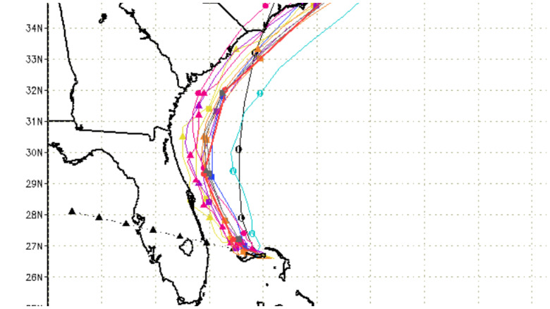
The latest Sept. 2 Hurricane Dorian spaghetti models.
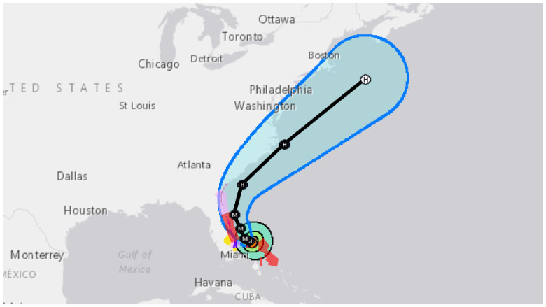
“At 200 PM EDT (1800 UTC), the eye of Hurricane Dorian was located near latitude 26.8 North, longitude 78.4 West. Dorian is moving very slowly toward the west-northwest near 1 mph (2 km/h),” the National Hurricane Center reported. “A slow
westward to west-northwestward motion is forecast during the next day or so, followed by a gradual turn toward the northwest and north. On this track, the core of extremely dangerous Hurricane Dorian will continue to pound Grand Bahama Island through much of today and tonight. The hurricane will then move dangerously close to the Florida east coast late tonight through Wednesday evening and then move dangerously close to the Georgia and South Carolina coasts on Wednesday night and Thursday.”
National Hurricane Center
Here is the West Palm Beach, Florida forecast, starting with Labor Day 2019.
The NWS Sept. 2 11 a.m. update reads, “**HURRICANE DORIAN REMAINS A POWERFUL MAJOR HURRICANE OVER GRAND BAHAMA**” The statement provides this update for Palm Beach County and West Palm Beach:
Extremely dangerous Hurricane Dorian is over Grand Bahama this morning. Dorian should move closer to the Florida east coast later today into Tuesday. While the center of Dorian is forecast to remain offshore of southeast Florida, periods of tropical storm force winds are expected over Palm Beach County through Tuesday night, with the greatest chances over the eastern portions of the county. Also, there is still a risk of hurricane force winds in coastal and metro Palm Beach County between tonight and Tuesday evening. A risk of tropical storm force winds at least in frequent gusts also continues from eastern Broward to Glades Counties as well as Lake Okeechobee, with occasional tropical storm force wind gusts possible elsewhere across South Florida particularly with any rain bands that were to impact the area.
Regardless of the eventual track of Dorian, the prolonged period of strong winds over the Atlantic coastal waters will cause very hazardous seas, rough surf, coastal flooding, and major beach erosion through the middle of the week.
The threat of life-threatening storm surge exists along the Palm Beach County coast today through the middle of this week, where water levels of 3 to 5 feet above ground level are expected somewhere for locations north of Lake Worth particularly along the ocean front. South of Lake Worth to Boca Raton, a 2 to 4 water level rise above ground level is
possible. These surge values are based on either the storm tracking a little closer to the coast and/or due primarily to wave action along the ocean front and king tides. Coastal sections of Broward County could also experience a water level rise of 1 to 3 feet above ground level while Miami-Dade County could experience 2 feet or less. Therefore, coastal flooding is a concern particularly in vulnerable locations along the southeast Florida coast through the middle of the week.Due to Dorian`s close proximity to the Florida east coast, small shifts in the track of the hurricane would bring substantial changes in expected impacts. Residents and visitors in South Florida should continue to monitor the progress of Hurricane Dorian until it has departed the region. Proper preparations should be rushed to completion in the watch and warning areas. Please follow the advice of local officials, including any evacuation orders.
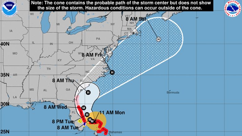
You can see the National Hurricane Center’s page for Hurricane Dorian here.
As of 2 p.m. on Sept. 2, this was the location of the hurricane:
LOCATION…26.8N 78.4W
ABOUT 25 MI…40 KM NE OF FREEPORT GRAND BAHAMA ISLAND
ABOUT 105 MI…170 KM E OF WEST PALM BEACH FLORIDA
MAXIMUM SUSTAINED WINDS…150 MPH…240 KM/H
PRESENT MOVEMENT…WNW OR 285 DEGREES AT 1 MPH…2 KM/H
MINIMUM CENTRAL PRESSURE…938 MB…27.70 INCHES
Extended Forecast for West Palm Beach
Here is the extended forecast for West Palm Beach from NWS:
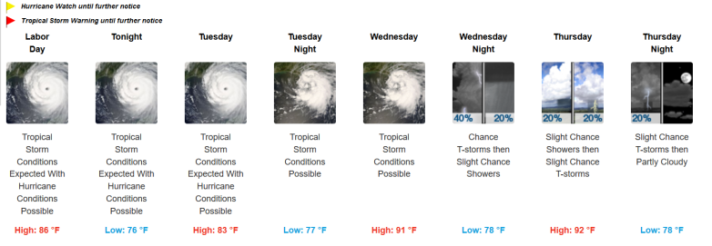
“Labor Day
Tropical storm conditions expected, with hurricane conditions possible. Showers and possibly a thunderstorm. High near 86. Chance of precipitation is 80%. New rainfall amounts between a quarter and half of an inch possible.
Tonight
Tropical storm conditions expected, with hurricane conditions possible. Showers and possibly a thunderstorm. Low around 76. Chance of precipitation is 80%. New precipitation amounts between three quarters and one inch possible.
Tuesday
Tropical storm conditions expected, with hurricane conditions possible. Showers, with thunderstorms also possible after noon. High near 83. Chance of precipitation is 80%. New rainfall amounts between 1 and 2 inches possible.
Tuesday Night
Tropical storm conditions possible. Showers and possibly a thunderstorm before 10pm, then showers likely. Low around 77. Chance of precipitation is 80%.
Wednesday
Tropical storm conditions possible. A chance of showers, with thunderstorms also possible after noon. Mostly cloudy, with a high near 91. Chance of precipitation is 40%.
Wednesday Night
A chance of showers and thunderstorms before 9pm, then a slight chance of showers. Mostly cloudy, with a low around 78. Southwest wind 9 to 14 mph, with gusts as high as 21 mph. Chance of precipitation is 40%.
Thursday
A slight chance of showers, with thunderstorms also possible after noon. Mostly sunny, with a high near 92. West wind 9 to 11 mph. Chance of precipitation is 20%.
Thursday Night
A 20 percent chance of showers and thunderstorms before 9pm. Partly cloudy, with a low around 78. West wind 6 to 8 mph.
Friday
A 30 percent chance of showers and thunderstorms after 9am. Mostly sunny, with a high near 93. West wind 6 to 8 mph.
Friday Night
A chance of showers and thunderstorms before 9pm, then a slight chance of showers. Partly cloudy, with a low around 77. Chance of precipitation is 30%.
Saturday
A 30 percent chance of showers and thunderstorms. Mostly sunny, with a high near 91.
Saturday Night
A 30 percent chance of showers and thunderstorms. Partly cloudy, with a low around 77.
Sunday
A 30 percent chance of showers and thunderstorms. Mostly sunny, with a high near 90.”
READ NEXT: When Will Hurricane Dorian Turn North?