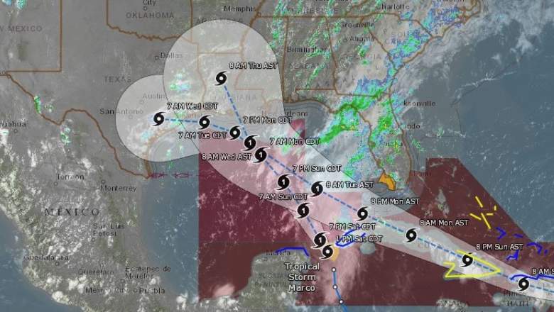
NOAA Storm path predictions by the NOAA.
Tropical storms Laura and Marco are expected to strengthen to hurricane levels in the near future. This would be the first time in recorded history that two hurricanes were in the Gulf at the same time, Science Alert reported. (Two tropical storms have been in the Gulf of Mexico simultaneously before — in 1959 and 1933 — but this would be the first time for two hurricanes.) Where are the storms now and where are they heading? Read on to see live radar and maps of the storms, along with a map of their projected future paths.
Live Streams, Trackers & Radars for Marco & Laura
This first live radar is from Windy.com. This radar is very helpful for tracking the storms’ locations. You can press the + button on the right-side of the map to zoom in more closely. You can also move the map ahead in time to see where the storm is forecast to be headed.
Note that depending on your browser, you might need to click on the map and change the orientation to see both storms:
Google has a storm tracker here for tracking Marco and Laura. It’s also embedded below. Depending on your browser, you may need to zoom into the map below using the + button to see the storm’s track. (Some browsers will show a far-away view despite the settings, but zooming in will allow you to see the map in full.) This map will update automatically. As you can see, the projected cones currently have the storms’ paths potentially overlapping.
Another live storm tracker, from NowCoast at NOAA.gov, is here.
Marco’s & Laura’s Projected Paths
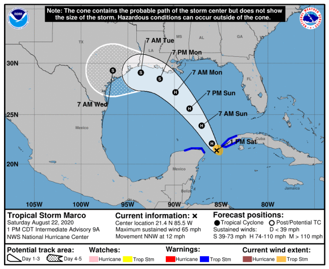
Below is a map from the National Hurricane Center showing the Marco’s projected paths.
Marco is forecast to strengthen to a hurricane by Saturday night, and it will move across the central Gulf of Mexico as a hurricane on Sunday, approaching the Gulf Coast on Monday, NOAA reported.
The storm’s current location as of 4 p.m. on August 22 is 21.9 N, 85.7 W, 50 miles west of the western tip of Cuba and 540 miles south-southeast of the mouth of the Mississippi River. Maximum sustained winds are 65 mph and movement is 340 degrees at 13 mph (north-northwest.) Minimum central pressure is 992 MB or 29.30 inches.
A hurricane watch is in effect for:
- Intracoastal City Louisiana to the Mississippi/Alabama border
- Lake Pontchartrain, Lake Maurepas, and Metropolitan New Orleans
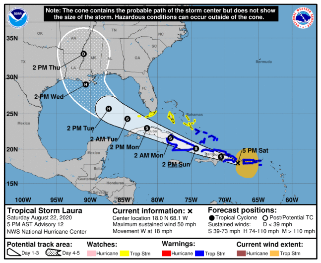
Next is a map from the National Hurricane Center showing Laura’s projected path.
Laura’s long-range intensity is still uncertain because of its movement over the Greater Antilles. But it’s expected to strengthen over the Gulf of Mexico by the middle of the week, NOAA reported. It’s worth noting that current predictions don’t have them making landfall at the same time. NOAA’s path predicts Laura to make landfall sometime on Wednesday, while Marco might be making landfall Monday night or Tuesday.
As of 5 p.m. AST on August 22, Laura was 18.0 N, 68.1 W, and about 100 miles west of Ponce, Puerto Rico and 125 miles east-southeast of Santo Domingo, Dominican Republic. Maximum sustained winds are 50 mp and it’s moving west or 280 degrees at 18 mph. The storm’s minimum central pressure is 1004 MB or 29.65 inches.
READ NEXT: The latest COVID-19 deaths, cases, and updates


