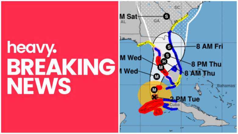
Hurricane Ian is slowly making its way to Florida. The storm is currently a Category 3 as of 2 a.m. Eastern on Wednesday, and all eyes are on the hurricane to see if it continues to grow. Where is Hurricane Ian now? Read on to see live radar and maps of the storms to help you track its progress and location.
Live Radar & Video Streams Reveal Ian’s Location
Live radar and maps can help you keep track of Hurricane Ian’s current location and where the storm is moving. On Tuesday morning, the storm had intensified to be a Category 3, Accuweather reported. It remained a Category 3 as of 2 a.m. on Wednesday, but was still expected to strengthen. The storm is expected to make landfall somewhere on the central Florida coast on Wednesday evening. But note that with hurricanes, situations can change quickly.
This first live radar, embedded below, is from Windy.com. This radar is one of the most helpful for tracking Ian’s location live. You can press the + button on the right side of the map to zoom in more closely. You can also move the map ahead in time to see where the storm is forecast to be headed. Depending on your browser, you might need to click on the map and drag it to see Ian’s current location.
Weather.com noted there is a lot of uncertainty about where it will make landfall. It will likely be at least a Category 3 if it makes landfall later on Wednesday in Florida, possibly bringing the worst of the weather to the southwest Florida region, including Fort Myers and Charlotte Harbor. However, Weather.com also noted that it might track more westward, which would bring a worsening storm surge to the Tampa-St. Pete-Clearwater region.
Google.com also has a live weather tracker for Hurricane Ian here.
NOAA has an interactive live map here.
Live Tracker Videos & Radars Are Also Available
You can also watch videos of live trackers.
WFAA has a live Ian tracker here or embedded below.
NBC News is also tracking Ian live in the video below.
Ian’s Projected Path

As of 2 a.m. Eastern on Wednesday, September 28, the National Hurricane Center (NHC) provided a map of Ian’s projected path, which you can see above or via the link here. At that time, Ian was located 25.2N, 83.0W, about 95 miles southwest of Naples, Florida. Maximum sustained winds were 120 mph and the storm was moving north-northeast or 15 degrees at 10 mph. Minimum central pressure was 953 MB or 28.14 inches.
The National Hurricane Center noted at 2 a.m.:
At 200 AM EDT (0600 UTC), the center of Hurricane Ian was located near latitude 25.2 North, longitude 83.0 West. Ian is moving toward the north-northeast near 10 mph (17 km/h). This general motion with a reduction in forward speed is forecast tonight and Wednesday, followed by a turn toward the north on Thursday. On the forecast track, the center of Ian is expected to approach the west coast of Florida within the hurricane warning area this morning, and move onshore later today. The center of Ian is forecast to move over central Florida Wednesday night and Thursday morning and emerge over the western Atlantic by late Thursday.
READ NEXT: Hallmark Reveals Early Countdown to Christmas Lineup