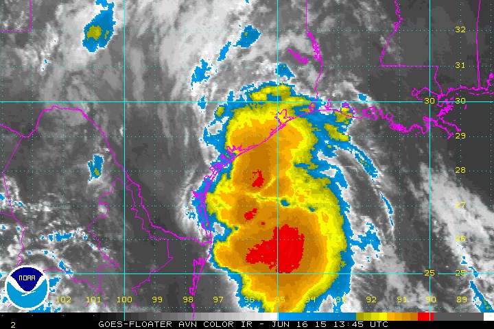
Tropical Storm Bill makes its way to the Texas coastline. (National Hurricane Center)
Residents along the Texas coastline from Houston to Corpus Christi are bracing for more flooding on Tuesday as Tropical Storm Bill churns its way to land from the Gulf of Mexico. The storm is expected to bring heavy rain, high winds and flooding to an area that has already been inundated over the past month, the National Hurricane Center says.
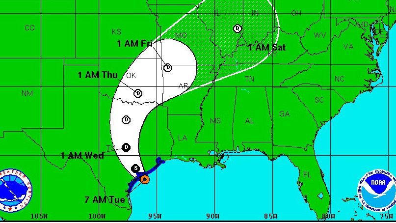
The storm is also expected to bring heavy rain to eastern Oklahoma, western Arkansas and southern Missouri, with the possibility of tornadoes in eastern Texas and western Louisiana Tuesday night, the National Hurricane Center says in its advisory.
Here’s what you need to know:
1. The Storm Will Bring Between 4 to 8 Inches of Rain
Tropical Storm Bill is expected to bring heavy rain, high winds and flooding to Texas as it makes landfall on Tuesday. (National Hurricane Center)

Tropical Storm Bill is expected to bring 4 to 8 inches of rain for most of eastern Texas and eastern Oklahoma, with some isolated areas of eastern Texas possibly getting up to 12 inches, the National Weather Service’s National Hurricane Center says in its advisory.
The storm is also likely to bring 2 to 4 inches of rain to western Arkansas and southern Missouri.
“Since there is not enough time for the storm to ramp up into a powerful hurricane with high winds, the main concerns have been and will continue to be the potential for heavy rainfall and major flooding,” said AccuWeather Hurricane Expert Dan Kottlowski.
A tropical storm warning is in effect from Baffin Bay, Texas, which is near Corpus Christi, all the way along the coastline to High Island, which is near Galveston, Texas.
2. The Eye of the Storm Made Landfall Late Tuesday Morning
.@houstonchron photog @jonjshapley trying to stay upright on Beach Road in Matagorda #houwx #TSBill http://t.co/MZUNkGgrp1

The storm brought high winds and rain to the Texas coastline starting Monday night into Tuesday morning.
A voluntary evacuation order was issued Monday by the Galveston County Office of Emergency Management for residents of Bolivar Peninsula as rain caused flooding of State Highway 87 near High Island, according to Weather.com. Residents were warned they may be stranded if more roads flood.
The eye of the storm will made landfall at about 11:45 a.m., according to the Houston Chronicle. Wind gusts were as high as 53 mph, the newspaper reports.
“Bill is expected to weaken slowly as soil moisture levels and environmental humidity across Texas are already high,” said AccuWeather Meteorologist Evan Duffey. “While the best chance for strong winds will be at the coast, strong wind gusts could continue inland quite a ways due to the continued intensity of the storm.”
Accuweather Meteorologist Chyna Glenn said, “rainfall will result in significant flooding across central and eastern Texas through Wednesday, including the cities of Houston, Dallas and Austin.”
3. Tornado Watches are in Effect Across the Region
The storm also brings the threat of tornadoes in eastern Texas and western Louisiana as it moves through the area, the National Hurricane Center says. There are tornado watches in place.
4. The Texas Emergency Operations Center is on ‘Elevated’ Alert
Coastal #Texas #flooding as #Bill approaches. #TXwx RT@jlperry_jr @MichaelBerrySho Rawlings Bait Camp in Matagorda. http://t.co/wJWPsUBsTT

Texas Governor Greg Abbott has announced an elevated activation for the state’s emergency operations center, while also approving the use of state resources for rapid deployment.
“As this tropical system develops, the state stands ready to provide support to communities as needed, and we urge Texans to closely monitor the changing weather conditions in their area and heed warnings from local and state officials,” Abbott said in a statement. “Any additional rainfall will exacerbate already saturated grounds, which could quickly lead to dangerous flash flooding and extended river flooding.”
5. Texas Is Still Recovering From May’s Record-Setting Rainfall
Texas received record-setting rainfall in May, with an average of 7.54 inches statewide, according to the Office of the State Climatologist at Texas A&M University. The previous high was 6.66 inches in July 2004.
“It has been one continuous storm after another for the past week to 10 days in several regions of the state. It has rained so much that the ground just can’t soak any more moisture into it, and many creeks and rivers are above flood stage,” State Climatologist John Nielsen-Gammon said on May 27.
The heavy rain caused flooding that killed more than 30 people.