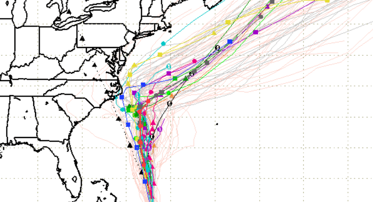
SFWMD Hurricane Maria September 23 spaghetti plot.
Hurricane Maria, now a category 3 hurricane with 115 mph winds, has already rampaged through Puerto Rico and the Turks and Caicos Islands, but where will the hurricane head next?
Although the hurricane is expected to weaken, “Maria’s forecast track has shifted closer to the U.S. east coast, and it is becoming increasingly likely that some direct impacts will occur along portions of the coast next week,” the National Hurricane Center reported, and spaghetti models bear this shift out. “Interests along the coast of the Carolinas and the Mid-Atlantic should monitor the progress of Maria, as tropical storm or hurricane watches may be needed for part of this area on Sunday.”
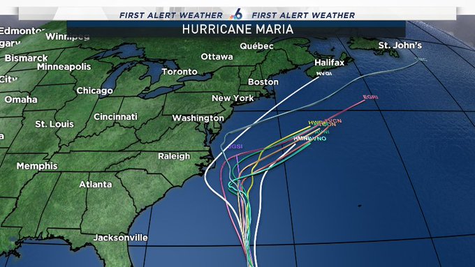
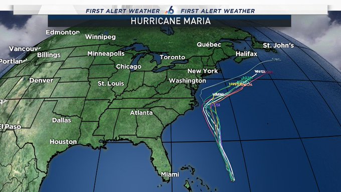
SAT 11AM: Spaghetti Plot still shows Maria going north then east. Question: When exactly does the turn happen? @nbc6

Spaghetti models show Maria coming close to North Carolina.

“Maria will move closer to the US East Coast and Bermuda by the middle of next week,” CNN reported, adding, “but it is too soon to determine, what, if any direct impacts there might be in these areas.” Swells, dangerous surf, and rip tides are expected on the U.S. east coast, according to CNN.
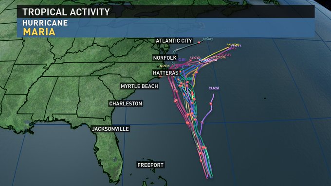
All of the spaghetti models take #Maria out to sea beyond the Outer Banks. Regardless, the entire Northeast needs to monitor this storm.
“Swells generated by Maria are increasing along portions of the southeastern United States coast and Bermuda and will be increasing along the Mid-Atlantic coast tonight and Sunday,” the National Hurricane Center said. See its Maria forecast page here.
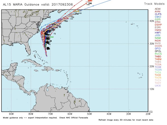
For days, spaghetti and other models have shown Maria turning north and missing Florida and the southeastern seaboard. Some of the models then showed that the northeastern United States could be in potential peril from the storm, although this was not by any means certain. The models are projections, and the storm could continue to shift. The latest models for Saturday show the storm coming closer to the northeast seaboard.
Spaghetti Plot shows why the Mid-Atlantic, Northeast & New England coastlines will be watching Maria closely. @nbc6
Here’s the September 23 spaghetti model from the South Florida Waste Management District.
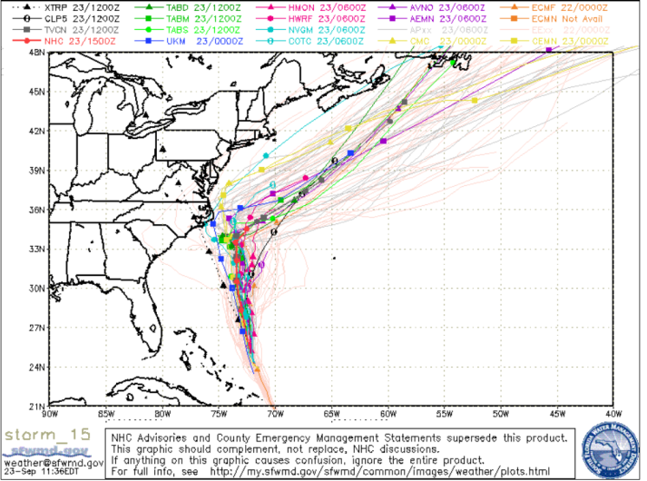
Saturday September 23 spaghetti model for Hurricane Maria.
According to CNN, the storm is projected to progressively weaken on Sunday and Monday.
For comparison purposes, this was the model the morning of September 22.
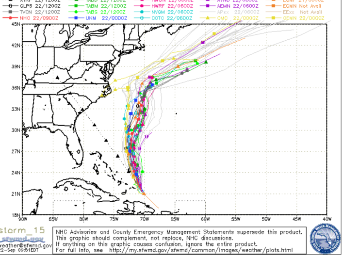
SFWMDSpaghetti model for September 22.
Cyclocane is a great site to get updated spaghetti model paths for Hurricane Maria. The site’s spaghetti model for Maria on September 22 shows a similar northern track for Maria away from the American coast.
The Google crisis map is also a good way to follow the storm’s path.
Here’s the Saturday forecast cone from the National Hurricane Center.
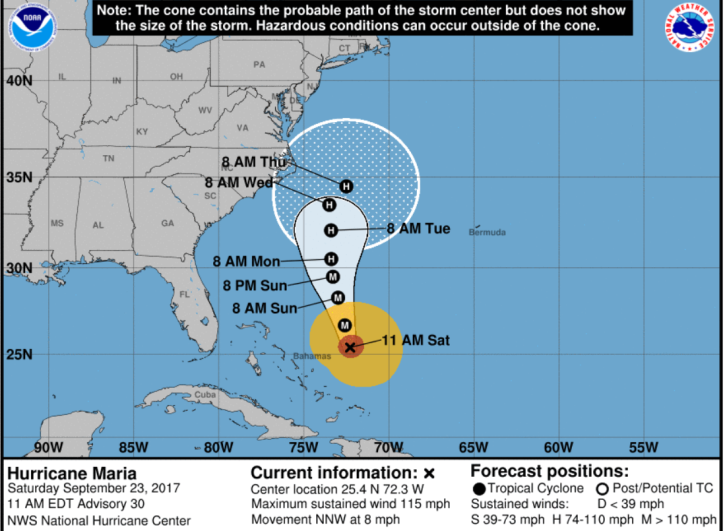
NHCHurricane Maria forecast cone for Saturday, September 23.
The National Hurricane Center wrote on September 23:
“At 1100 AM EDT (1500 UTC), the eye of Hurricane Maria was located near latitude 25.4 North, longitude 72.3 West. Maria is moving toward the north-northwest near 8 mph (13 km/h), but a turn toward the north is expected by this evening. A northward motion with a decrease in forward speed is forecast to then continue through Monday. On the forecast track, Maria will move away from the Bahamas into the open waters of the western Atlantic today.
Data from an Air Force Reserve reconnaissance aircraft indicate that maximum sustained winds have decreased to near 115 mph (185 km/h)
with higher gusts. Maria is a category 3 hurricane on the Saffir-Simpson Hurricane Wind Scale. Little change in strength is forecast during the next 48 hours.
Hurricane-force winds extend outward up to 60 miles (95 km) from the center, and tropical-storm-force winds extend outward up to 195
miles (315 km). The minimum central pressure based on aircraft data is 952 mb (28.12 inches).”