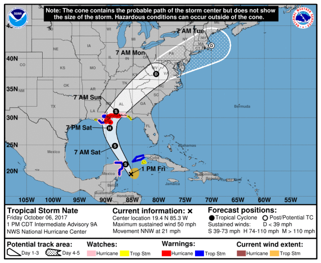
NOAAThe latest path for Tropical Storm Nate, which will likely churn into a Category 1 hurricane as it makes landfall in New Orleans.
A tropical storm that’s already killed over 20 people in Central America has its path set on New Orleans.
Multiple warnings have been issued for the New Orleans area ahead of Tropical Storm Nate. Those include a hurricane watch, a tropical storm warning and a storm surge warning. The storm surge warning means that life-threatening water levels are expected within the area in the next 36 hours, and a tropical storm warning means wind conditions will effect the area within the same time frame.

On Thursday, Louisiana Gov. John Bel Edwards declared a state of emergency as the latest NOAA projections look as if the storm will directly hit the southeastern part of Louisiana. Edwards has mobilized 1,300 National Guard troops in preparation, including some that are monitoring New Orleans’ pump and drainage systems.
The latest path shows Nate growing into a Category 1 storm Saturday evening before making landfall early Sunday morning. It’s expected to dissipate as it makes landfall and moves toward the northeast.
Winds in excess of 60 mph are expected to be felt in the area, and the uptick in wind speed should be felt beginning Saturday morning for the New Orleans area. Check below for the latest map showing the “most likely arrival time” of the tropical-storm-force winds.
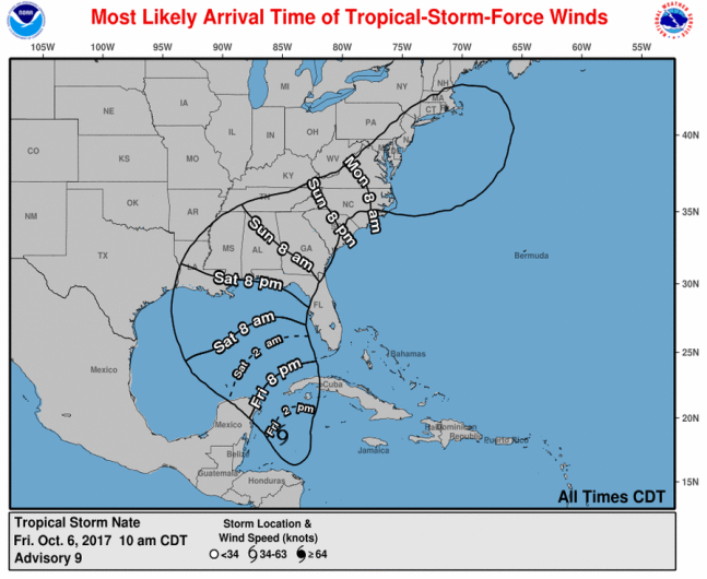
A wind map for Tropical Storm Nate.
New Orleans Mayor Mitch Landrieu also declared a state of emergency for the city, warning that areas outside of levee protection could see a storm surge 3-to-6 feet in size.
There is no need to panic. Be ready and prepare. Get a plan. Prepare to protect your personal property.
To help people prepare for the storm and the impending surge, the New Orleans Fire Department is handing out free sandbags at any time of the day to residents.
#NOLAFireDept assisting residents w/ free sandbags for TS #Nate. Available 24/7 until further notice.


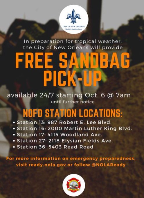
In preparation for TS #Nate, free sandbags are available 24/7, starting tom. at 7 a.m. until further notice at select @NOLAFireDept stations
#NOLAFireDept is getting ready to help you prepare for TS #Nate! Sandbags will be available for pickup 24/7 starting tomorrow.


Here’s the latest weather forecast for New Orleans through the weekend, according to AccuWeather:
Friday: Humid with sun and some clouds, high of 85 degrees. Winds from the ENE at 10 mph and gusts reaching 18 mph.
Friday night: Partly cloudy, very warm and muggy with a low of 78 degrees. Thunderstorms coming late. Winds from the ESE at 9 mph and gusts reaching 15 mph.
Saturday: “Hurricane Nate” approaches with increasing winds and rain with damaging winds. High of 84 mph with winds from the ESE at 30 mph. Gusts topping out at 45 mph.
Saturday night: Heavy rain and strong winds from “Hurricane Nate.” Low of 77 degrees with damaging winds of 40 mph from the SE and gusts topping out at 79 mph.
Sunday: Wind and rain from “Hurricane Nate” during the morning with a few afternoon showers. Watch for flooding as winds from the W come at 26 mph and gusts reach 75 mph.
Sunday night: Cloudy, very warm and very humid with a low of 77 degrees. Winds from the SSW at 7 mph and gusts reaching 16 mph.
For the latest on Tropical Storm Nate, click here.