Hurricane Harvey became a Category 4 with 130 mph winds on August 25, and it reached the Texas coast. Although not directly in the path, people in San Antonio should still brace for the possibility of flash floods and strong winds. (You can read the August 26 update here. The hurricane is now a Category 1 storm with concerns in San Antonio centered around strong winds and heavy rainfall.)
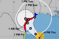
The hurricane was 35 miles from Corpus Christi at 7 p.m. and made landfall at Rockport not long after.
#Harvey making landfall as a Category 4 storm in the Rockport area t.co/hwhbADeKIc
Heavy rains are the biggest concern in San Antonio; at 7:29 p.m., showers were moving into the coastal plains. “Eye of Category 4 Harvey approaching the coast between Port Aransas and Port O’Connor Texas,” the National Weather Service wrote at 7 p.m. August 25. “Catastrophic flooding expected due to heavy rainfall and storm surge.”
Eye of Category 4 #Harvey almost onshore in Texas. Hurricane force winds reported at many observing stations. Landfall expected very soon.
The latest National Weather Service update at 7:22 p.m. August 25 said the storm was “about 150 miles southeast of San Antonio TX or about 90 miles south-southeast of Cuero TX.” It continued, “Hurricane Harvey expected to bring a life-threatening and catastrophic heavy rainfall event east of Interstate 35 and Interstate 37.”
7:29 PM CDT Showers continue to move into the coastal plains. Light to moderate rain will continue.
The National Weather Service is providing other updated information. You can see up-to-the-minute tracking maps here. See the latest forecasts and radar for San Antonio later in this story.
There is a risk of weak tornadoes developing in the area. In addition to rain, strong winds are also possible. The National Weather Service declared Harvey a Category 4 story just after 6 p.m.
6:04p – The National Hurricane Center now says Hurricane Harvey is a Category 4 storm with 130 mph sustained winds.
Check out this view of the storm:
Harvey se convierte en huracán de categoría 4 con vientos sostenidos de 130 mph. Super peligrosa la situación. #Harvey #ServicioPúblico
What’s the effect on San Antonio? Water. Lots of it. The National Weather Service reported that a flash flood watch was in effect from Friday afternoon through Monday morning for San Antonio. The flash flood watch was for “a portion of south central Texas, including the following areas, Atascosa, Bastrop, Bexar, Caldwell, Comal, De Witt, Fayette, Gonzales, Guadalupe, Hays, Karnes, Lavaca, Lee, Travis, Williamson, and Wilson” and starts at 1 p.m. August 25.
According to MySanAntonio.com, the “massive, slow-moving storm…could pack 60 mph winds and dump up to a foot of rain on parts of the Alamo City over the next several days.”
#Tropical storm force winds nearing the TX coast. Continuously updated #Harvey forecast: t.co/ba50CtWVxC

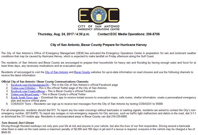
According to San Antonio.gov, “The City of San Antonio’s Office of Emergency Management (OEM) has activated the Emergency Operations Center in preparation for rain and inclement weather conditions that may be caused by Hurricane Harvey.” You can see a list of current Texas weather warnings and watches here.
The city added, “The residents of San Antonio and Bexar County are encouraged to prepare their households for heavy rain and flooding by having enough water and food for at least three days, any necessary medications and an evacuation plan.”
According to Fox News, the hurricane was the most powerful to “threaten the U.S. in 12 years.”
“Residents should be prepared for heavy rain & flooding from Hurricane Harvey…STAY home; STOCK up on food, water & medications; & STAY SAFE!” the City of San Antonio wrote on its official Facebook page on August 24, and that remained true on August 25.
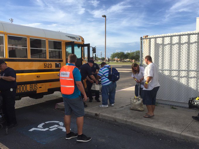
People boarding buses and evacuating to San Antonio because of Hurricane Harvey. @KRIS6News
According to The Houston Chronicle, Hurricane Harvey is poised to be “the first major hurricane to threaten the coast in more than a decade.”
Here’s what you need to know:
Closings, Evacuations, Volunteer Efforts
The initial outer bands of #hurricaneharvey are approaching Hallettsville and Cuero.
You can see a map of current road closings and flooding in San Antonio here.
KSAT-TV has published a list of San Antonio school and other closings and delays due to Hurricane Harvey. KENS5 also has another full and updated list of closings for San Antonio here.
7:50 PM CDT Light showers are moving westward across northern Burnet county. Only light rain at this time.
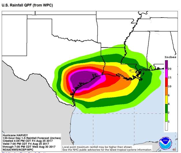
The rain is expected to continue for some time. “Copious amounts of rain are expected beginning Friday Afternoon and lasting through at least Monday morning as Tropical Storm Harvey moves onshore. This watch may need to be expanded in time and area over the next several days as Harvey lingers around the area through the weekend into early Monday. Rainfall totals in the watch area through early next week will average 10 to 20 inches along and east of Interstate 35 with isolated amounts in excess of 25 inches possible along and south of Interstate 10,” the National Weather reports for San Antonio.
“Significant flash flooding is possible as Harvey slowly moves or even stalls. Devastating mainstem river flooding is possible east of Interstate 35 and south of Interstate 10.”
5:50p – Isolated storms on the rain bands, but mod/heavy rain approaching Central TX
The city provided these other information sites:
Residents can sign up to receive text messages from the City of San Antonio by texting COSAGOV to 55000.
Residents should be prepared for heavy rain & flooding from #HurricaneHarvey. Check back 4 more information or visit t.co/azZwLYpKmc
The city’s Facebook page is also providing updates.
The city has provided information about volunteer opportunities and needs as well. “San Antonio Food Bank is accepting donations such as money, food, unused clothing, diapers & other supplies. Please DO NOT bring donated supplies directly to emergency shelters,” the city wrote. You can learn more information about that here.
The city also says that American Red Cross Serving Greater San Antonio needs volunteers to help those affected by Hurricane Harvey. Dial 3-1-1 to help.
Category, Warnings, & Windspeeds
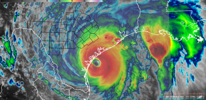
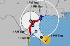
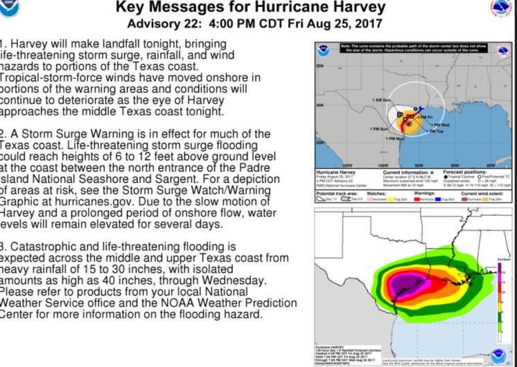
Hurricane Harvey, as expected, is now a powerful Category 4 hurricane. At 7 p.m. on August 25, “the eye of Hurricane Harvey was located by reconnaissance aircraft and NOAA Doppler radar near latitude 27.8 North, longitude 96.8 West. Harvey is moving toward the northwest near 8 mph (13 km/h), but its forward speed is expected to decrease during the next couple of days,” the National Weather Service reported. “On the forecast track, Harvey will make landfall on the middle Texas coast during the next several hours. Harvey is then likely to meander near or just inland of the middle Texas coast through the weekend.”
The update continued, “Reports from an Air Force Reserve Hurricane Hunter aircraft indicate that maximum sustained winds remain near 130 mph (215 km/h) with higher gusts. Harvey is a category 4 hurricane on the Saffir-Simpson Hurricane Wind Scale. Little change in strength is likely before landfall. Weakening is then expected over the weekend while the center moves inland over Texas.”
The Hazardous Weather Update for San Antonio from the National Weather Service for Friday evening reports: “A Hurricane Warning is in effect for 70 to 80 mph winds across Karnes and Dewitt Counties. A Tropical Storm Warning is in effect for winds of 40 to 50 mph across Atascosa, Bastrop, Bexar, Caldwell, Fayette, Gonzales, Guadalupe, Lavaca, and Wilson.”
The update continues, “A Flash Flood Watch is in effect from this afternoon through Monday morning across counties along and east of a line from Georgetown to Comfort to Jourdanton. There is a low risk of brief tornadoes east of I-35 and south of I-10 this evening into tonight associated with tropical rain bands.” Read the full update here.
According to the National Weather Service, 20+ inches of rain is “possible across Southeast portions of South Central Texas. Flash Flooding likely this weekend.”
“Hurricane Harvey continues to strengthen and will continue to move to the Northwest towards the Texas Coast. Tropical Storm and Hurricane Warnings are now in effect. The storm should impact South Central Texas Friday into the Weekend,” the National Weather Service reports.
This National Weather Service page has a detailed hourly forecast for San Antonio that includes windspeeds and many other data points.
You can check current weather warnings for the San Antonio area here.
The National Hurricane Center’s 7 p.m. August 25 summary read:
LOCATION…27.8N 96.8W
ABOUT 35 MI…55 KM E OF CORPUS CHRISTI TEXAS
ABOUT 50 MI…80 KM SSW OF PORT OCONNOR TEXAS
MAXIMUM SUSTAINED WINDS…130 MPH…215 KM/H
PRESENT MOVEMENT…NW OR 325 DEGREES AT 8 MPH…13 KM/H
MINIMUM CENTRAL PRESSURE…941 MB…27.79 INCHES
The National Hurricane Center reports that hurricane force winds are described as “one-minute average wind speeds of at least 74 mph” and tropical storm force winds are “one-minute average wind speeds of 39-73 mph.”
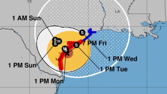
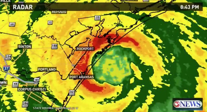
Path & Radar
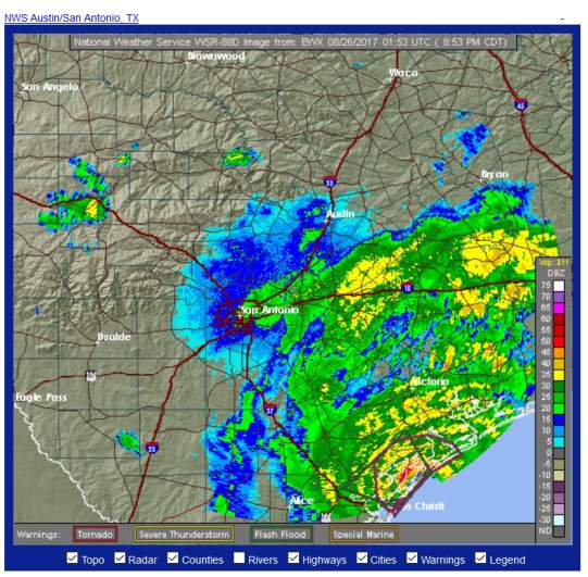
The latest radar for San Antonio at 9 p.m. on August 25.
The Houston Chronicle reports that the storm’s path is “is similar to that of Tropical Storm Allison,” which, in Harris County, “left 22 dead and 30,000 homeless, and caused more than $5 billion in property damages.”
You can see updated San Antonio radar reports here and here.
This page by the National Hurricane Center has a current map that tracks Hurricane Harvey’s path through Texas.
National Weather Service radar as of 9 p.m. on August 25, 2017.
Concerns were even more acute in Houston.
Forecast & Rainfall
San Antonio forecast as of 9 p.m. August 25.
You can see another updated weather forecast for San Antonio here on the National Hurricane Center’s website.
See a current graphical forecast map here.
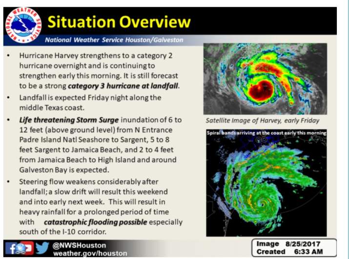
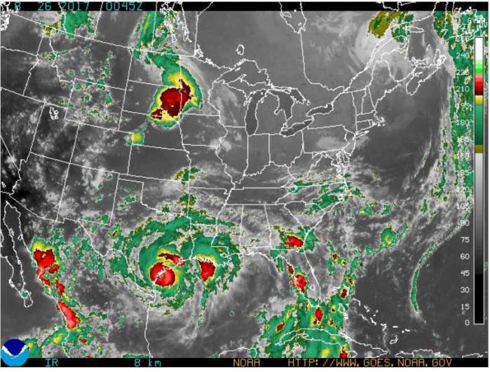
National Weather ServiceThe latest information on Hurricane Friday as of the morning of August 25.
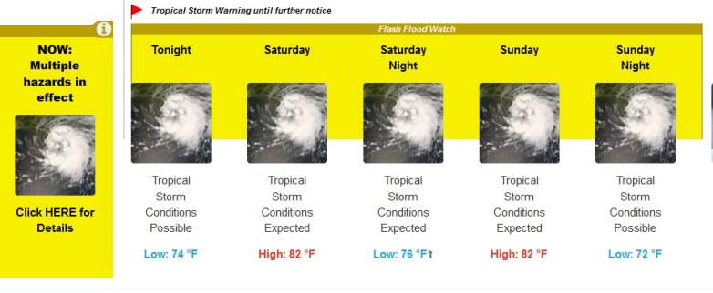
The San Antonio forecast for Friday, August 25, according to the weather service: “Tropical storm conditions possible, with hurricane conditions also possible. Showers and thunderstorms likely, mainly after noon. Cloudy, with a high near 88. Chance of precipitation is 60%. New rainfall amounts between a tenth and quarter of an inch, except higher amounts possible in thunderstorms.”
Friday Night: “Tropical storm conditions expected, with hurricane conditions possible. Showers and thunderstorms likely. Some of the storms could produce heavy rainfall. Cloudy, with a low around 75. Chance of precipitation is 70%. New rainfall amounts between 1 and 2 inches possible.”
Saturday: “Tropical storm conditions expected, with hurricane conditions possible. Showers and thunderstorms. Some of the storms could produce heavy rainfall. High near 85. Chance of precipitation is 80%.”
Saturday Night: “Hurricane conditions possible. Showers and thunderstorms. Some of the storms could produce heavy rainfall. Low around 74. Chance of precipitation is 80%.”
Sunday: “Tropical storm conditions possible. Showers and thunderstorms likely. Some of the storms could produce heavy rainfall. Cloudy, with a high near 82. Chance of precipitation is 70%.”
Sunday Night: “Tropical storm conditions possible. Showers and thunderstorms likely. Some of the storms could produce heavy rainfall. Cloudy, with a low around 73. Chance of precipitation is 60%.”
According to ABC 13, on August 24, “A Hurricane Warning has been issued for the Texas coast from Port Mansfield to Matagorda. A Tropical Storm Warning has been issued from north of Matagorda to High Island Texas. A Storm Surge Warning is in effect for Port Mansfield to San Luis Pass.”