
USGS Today's California earthquake struck near Ridgecrest.
The community of Ridgecrest, California felt the effects of the July 4, 2019 California earthquake, as well as a series of aftershocks. A larger quake has now struck the same area on July 5 – reportedly 7.1 magnitude.
You can read about the July 5, 2019 quake here.
Kern County Fire Chief David Witt reported July 6 that there were, thankfully, no deaths, major injuries or major collapses of buildings in Trona or Ridgecrest, the two hardest hit areas. Witt said there is damage, but authorities were still assessing the degree of it.
Kern County fire officials said in an evening news conference on July 5 they had they had no reports of major gas leaks. They said 178 through the canyon is closed. “We have a lot of people who are here to help, and we’re taking action,” said Kern County California Fire Chief David Witt.
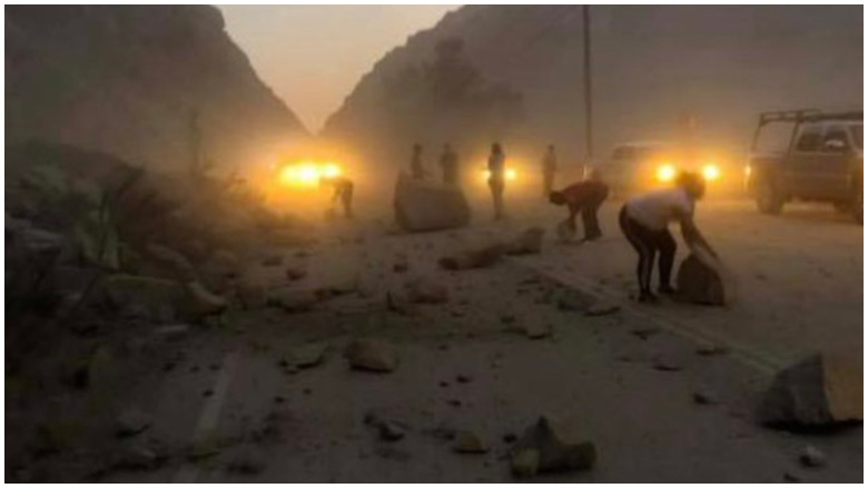
CHPScenes from the California earthquake on July 5.
Authorities were doing a “systematic search of Ridgecrest for life and property,” Witt said, adding that they were fielding a lot of medical aid calls from that community. He said officials knew of no fatalities at this time. He did not give an estimate of injuries on the evening of July 5. “We are launching a lot of people,” Witt said. “We have a strike team of engines.”
Witt said there were many concerns – a dam, the potential for buildings collapsed, and the possibility of people trapped. But he said authorities had no reports at the moment of major building collapses. “The first part is finding where those buildings are…there are so many calls for help that we have a backlog of calls in the Ridgecrest area,” according to Witt.
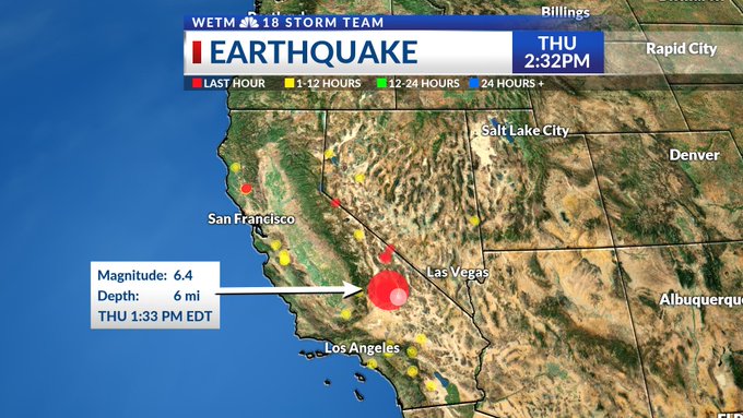
The magnitude 6.4 earthquake struck Southern California on the Fourth of July. The center of the quake was near Searles Valley and Ridgecrest, which is in Kern County, CA, and has a population of about 29,000. There were reports of people needing medical assistance and of damaged roadways and buildings. In Ridgecrest, the mayor told CNN that five fires were under control and other damage had occurred.
“It almost gave me a heart attack,” said Cora Burke, a waitress at Midway Cafe in Ridgecrest, told ABC11. “It’s just a rolling feeling inside the building, inside the cafe and all of a sudden everything started falling off the shelf, glasses, the refrigerator and everything in the small refrigerator fell over.”
Jenny Campbell, a bookkeeper at the Albertsons in Ridgecrest, told the Los Angeles Times that the store shook, and light fixtures, bottles and glass fell. “I was just shocked. It was like nothing I’ve ever experienced,” she told the newspaper, adding that the store lost power.
The Earlier Quake Occurred on a Fault About 10 Miles From Ridgecrest
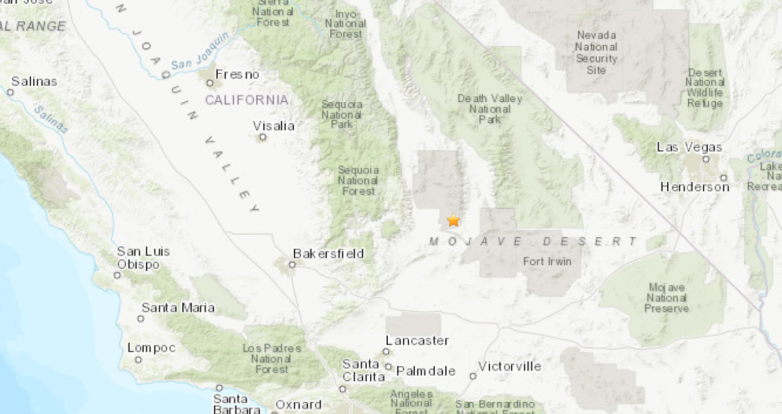
USGS map of the earthquake epicenter.
An after-shock hit in the middle of a Kern County press conference after the July 4 earthquake. Watch:

The following information is about the July 4 quake.
The Ridgecrest, CA police chief said authorities were “inundated with calls, with fires, obviously stores that were shaken with stuff falling off the shelves and various items falling…” Authorities reported multiple minor injuries in that community as a result of the quake.
Dr. Lucy Jones, a well-known, seismologist, wrote on Twitter that the quake was preceded by another. “A M6.6 near Ridgecrest. The M4.2 a half hour before was a foreshock. This area had lots of M5+s in the 1980s. More soon,” she wrote.
She also wrote that the earthquake was not on the San Andreas fault, noting, “M6.4 on a strikeslip fault about 10 miles from Ridgecrest. Not the San Andreas fault. It is an area with a lot of little faults but no long fault.”
She also noted, “The #Ridgecrest earthquake is having a robust aftershock sequence. There have been 6 M4+ events and ~30 M3+ in the first 90 minutes. That means there will be plenty more aftershocks today.”
You can see more data and maps on California quakes here. You can see the USGS interactive earthquake map here.
According to the USGS Earthquake Hazards Program of the U.S. Geological Survey, the quake had these attributes: “M 6.4 – 12km SW of Searles Valley, CA. 2019-07-04 17:33:48 (UTC) 35.705°N 117.508°W8.7 km depth.” San Bernardino County Fire tweeted that there were no injuries, writing that it was “conducting assessment of region after #EARTHQUAKE. No injuries reported, however buildings and roads have sustained varying degrees of damage.”
According to KTLA, people felt the quake as a “long, rolling motion,” for about 20 seconds. ABC 11 reported that objects shook and were knocked to the ground at Ledesma Chiropractic in Ridgecrest.
The Ridgecrest Mayor Says the Fires Are Under Control & Asked People Not to Panic
Several earthquakes hitting California. U.S. Geological Survey reports a 6.4 magnitude earthquake hit southern California, SW of Searles Valley at 10:33 am their time (1:33 pm our time).
“This would be our 7th or 8th one. Oh, my goodness, there’s another one right now. As I understand, we have five fires. We have broken gas lines…the police are out doing a marvelous job,” said Ridgecrest Mayor Peggy Breeden to CNN; she said she was experiencing another after shock as she spoke to the Cable News Network. She asked people to check on their neighbors in the community close to the epicenter. She said police, fire and volunteer organizations were out assessing the situation. She said that the five fires were under control and the cause was not clear.
Sacramento News 6.4 magnitude earthquake rattles Southern California t.co/fM5bTNzMX2

“We’re asking people to not panic,” she said, adding that Ridgecrest is a city of about 28,000 people. She said there were numerous ambulances going by. She said she wasn’t sure why exactly.
Ridgecrest Mayor Peggy Breeden reports on damage and continued rolling aftershocks in her town, which is near the epicenter of the California earthquake. t.co/8J0umS8RWf
The San Bernardino County Fire Department continued, “Mult buildings with minor cracks; broken water mains; power lines down; rock slides on certain roads. No injuries/fires. Addl engine companies and #USAR HeavyRescue 305 moving to the area.” The LA County Sheriff’s Department wrote, “Now that it looks like we are done shaking & rolling PLEASE call your family, friends, and check on any elder or disabled persons you know. 6.6 magnitude #earthquake out of #ridgecrest CA REPORTED AT 10:02AM.” (The quake was initially reported as a 6.6 magnitude and then downgraded to 6.4.)
The Kern County Fire Department wrote on Twitter of damage “#EarthquakeResponse @kerncountyfire resources working nearly 2 dozens incidents ranging from medical assistance to structure fires in and around the city of Ridgecrest, CA. @kerncountyfire Urban Search and Rescue teams en route.” The FD then added: “We can confirm evacuations are underway @ Ridgecrest Regional Hospital.”
According to the City of Los Angeles, “The #ShakeAlertLA app only sends alerts if shaking is 5.0+ in LA County. Epicenter was 6.4 in Kern County, @USGS confirms LA’s shaking was below 4.5. We hear you and will lower the alert threshold with @USGS_ShakeAlert.” LAPD headquarters wrote, “At this time, the LAPD has not received any reports of damage or calls for service within the City of Los Angeles related to the #earthquake. Remember, 911 is only to report emergencies. This was a strong one, and a good reminder to be prepared.”
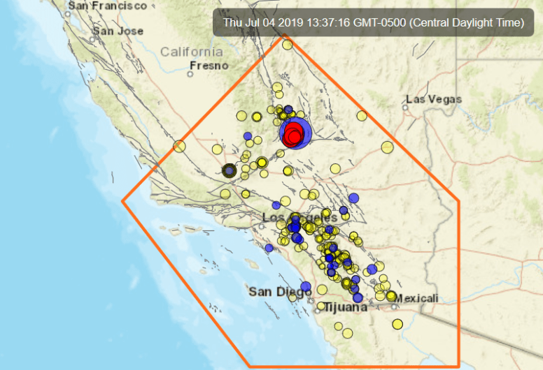
The Southern California Seismic Network offers this map:
According to the Los Angeles Times, “today’s earthquake was the largest in Southern California since the 1994 6.6 Northridge quake.” However, that one was located in a populated area, and thus it killed dozens of people, the newspaper noted. This one wasn’t in metro LA.
Dr. Jennifer Andrews, writing for the Southern California Seismic Network website, noted the following:
“Event
04 Jul 2019 10:33:48 PDT, (35.705, -117.508), depth 8.7km.
12km SW of Searles Valley, California
Aftershocks
As of 04 Jul 2019, 11:05AM PDT, there have been 20 aftershocks recorded.
The largest was M4.7 (smallest M2.2).
More aftershocks may be expected in the next few days, the largest expected is approximately 1 magnitude unit smaller than the mainshock.
There is a small chance (about 5%) that a larger quake could occur, with the likelihood decreasing over time.
Possible Foreshocks
There were 9 events during the 3 days prior to the earthquake (within a 10 km radius).
The largest was M4.0 (2019/07/04).”
She also noted that, since the network began keeping records in 1932, “we’ve had 31 events of M4 or greater within 10km of today’s event. he largest historic event was M5.8 on 1995/09/20. he most recent historic event was M4.1 on 01 Nov 2011.”