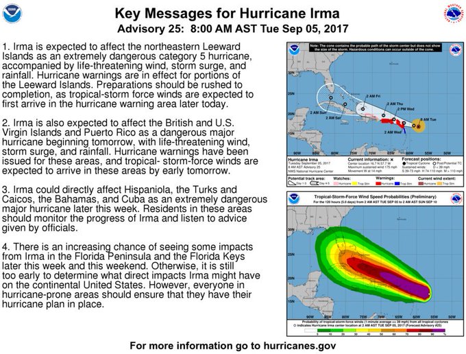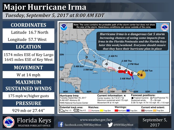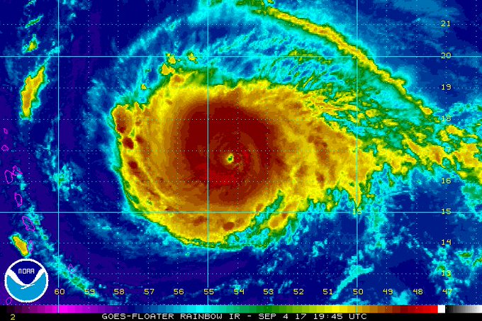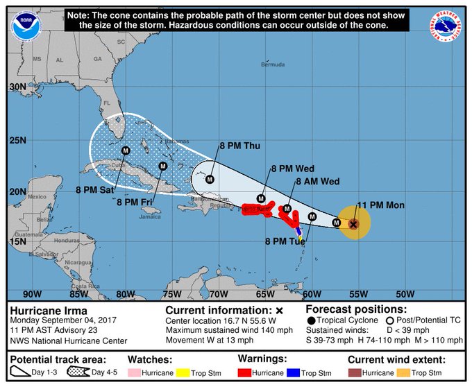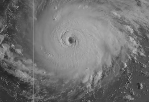
National Weather Service Hurricane Irma on September 5.
The Florida governor has declared a state of emergency as Hurricane Irma reaches a Category 5 storm. The Florida Keys are currently in the hurricane’s path, although the storm remains unpredictable.
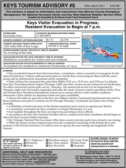
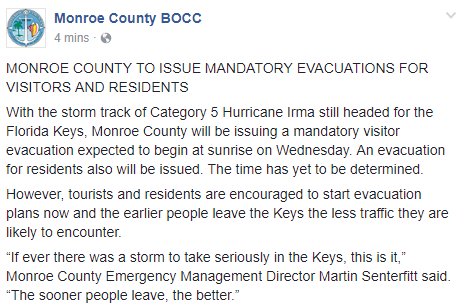
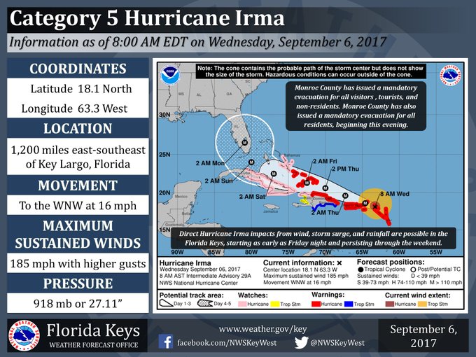
Monroe County has issued a mandatory evacuation for tourists, visitors, and non-residents starting at 7 a.m. on Wednesday September 6. A mandatory evacuation for residents of the Florida Keys begins at 7 p.m. September 6. The extended forecast for Key West says hurricane conditions are possible Saturday and Sunday.
See the latest September 6 advisory:
Irma is a Category 5 hurricane, with maximum sustained winds at 185 mph. The Florida keys have been in the projected path of the hurricane since at least the September 4 late evening forecasts from the National Weather Service (that hadn’t changed on September 6). All Monroe County schools are closed until further notice.
Here is the latest forecast come from September 6:
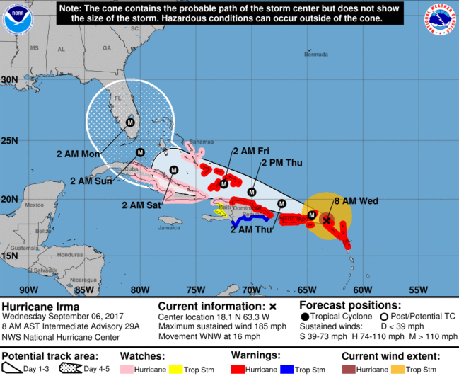
National Hurricane Center
The National Weather Service noted in its September 6 hazardous weather outlook for Key West: “Hurricane Irma is forecast to be near the southeastern Bahamas on Friday and move through the Florida Keys area through the weekend. It is still too early to provide specifics on impacts by Irma on the Florida Keys. All residents and visitors in the
Florida Keys should continue to closely monitor the latest Hurricane Irma forecasts from the National Hurricane Center and follow directions by Monroe county officials.”
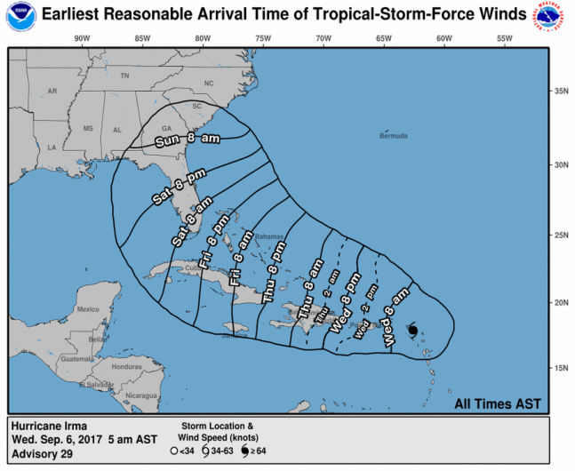
Here’s the latest time map:
Here’s another look at the September 6 track:
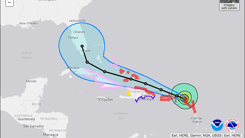
National Hurricane Center
However, there are some other models that show Irma could miss Florida and that it’s tracking eastward underscoring the storm’s continuing predictability.
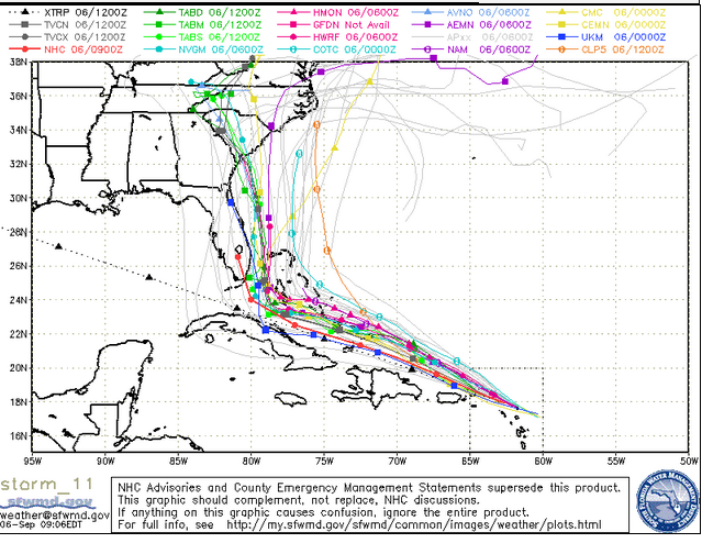
South Florida Water Management DistrictSpaghetti model from September 6.
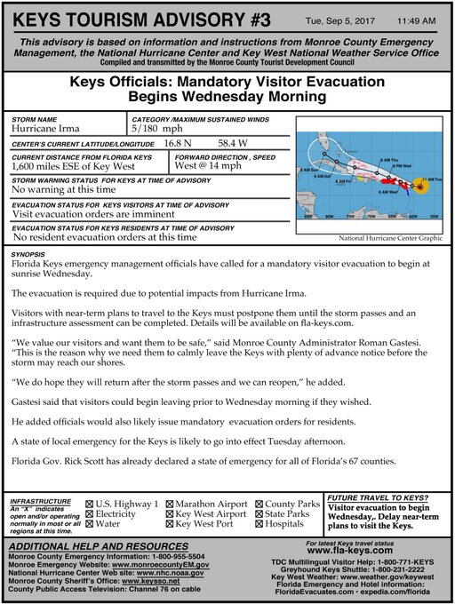
People with vacations planned in the Florida Keys were urged to postpone them. Rumors about gas shortages in Key West were said to be unfounded.
“We value our visitors and want them to be safe,” said Monroe County Administrator Roman Gastesi. “This is the reason why we need them to calmly leave the Keys with plenty of advance notice before the storm may reach our shores.
The chances for direct impact from Hurricane Irma on the Florida Keys this weekend or later in the week are increasing, but the magnitude is still not clear. Tropical storm force winds could be seen in the Keys by Friday evening. “It is too early to determine what direct impacts Irma might have on the Keys or other parts of Florida, but preparation is key, emergency management officials said,” according to the Florida Keys website.
“It’s already the strongest hurricane ever recorded outside the Caribbean and the Gulf of Mexico, and it’s likely to make landfall somewhere in Florida over the weekend,” The Washington Post reported.
“All of Florida — especially South Florida and the Keys — should be preparing for a major hurricane landfall on Sunday. Tropical-storm-force winds are expected to arrive as soon as Friday.” The Post noted of the storm’s unpredictability: “Computer models are in strong agreement that by Saturday, Irma will be approaching the Florida Keys — where dangerous storm conditions are likely. Then, they show a sharp northward turn by Sunday morning. The precise timing and location of the turn has huge implications for Florida.” It’s not clear how the storm will track after that, The Post reported – east Florida, west Florida or straight up into the state.
“This is an important message for the residents of the Florida Keys. Hurricane Irma is forecast to track just north of the Caribbean islands this week, potentially approaching the Keys late this week. Tropical Storm conditions are possible as early as Friday, but it is still too early for specific details on the strength and track of this system. As a result, residents and visitors of the Florida Keys are encouraged to monitor the latest forecasts concerning Hurricane Irma from the National Hurricane Center and your local forecast office. Now is a good time for residents to go over their hurricane plan. Visitors are encouraged to check with hotels and local officials regarding initial preparedness actions that may need to be initiated.”
Follow updated radar for Key West here. See updated infrared satellite maps for the area here. See an hourly forecast for Key West here. Track Hurricane Irma’s path here. See the hazardous weather outlook for Key West here.
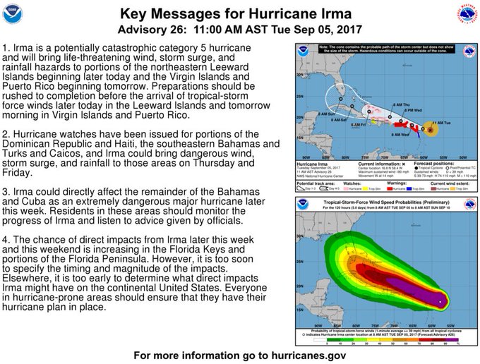
Here’s the hurricane’s path as of September 5:
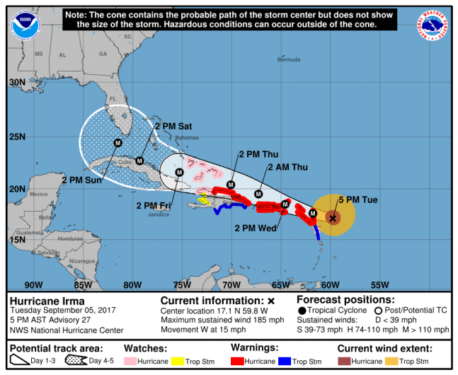
NOAAThe NHC’s projection for Hurricane Irma as of Tuesday at 5 p.m. AST.
Here’s another look at it:
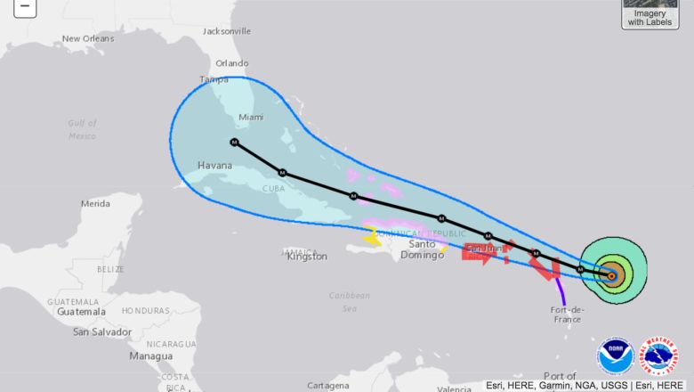
National Hurricane Center
The National Weather Service’s Key West office wrote on September 4: “#FLKeys are now located in the five day @NHC_Atlantic Hurricane #Irma track forecast cone. Impact chances increasing. #KeyWest #flwx.” See Hurricane Irma prep information for the Florida Keys here. On September 5, the alert said, “All of the Florida Keys remain within the five day National Hurricane Center track forecast cone. There continues to be an increasing chance of Hurricane Irma impacts in the Florida Keys, starting as early as Friday evening and persisting through the weekend. Everyone should ensure that they have their hurricane plan (ready.gov/make-a-plan) in place and their disaster supplies kit (ready.gov/build-a-kit) stocked with essential items.”
Monroe County, Florida announced: “With the entire Florida Keys in the National Weather Service’s five-day forecast error cone, the Monroe County Emergency Operation Center (EOC) will activate at noon Tuesday.”
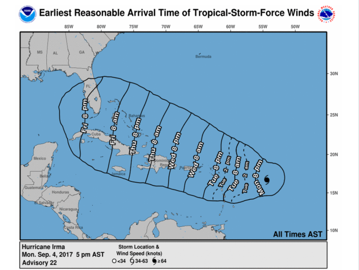
The County press release noted, “There is a high confidence for a major hurricane nearing south Florida, the Keys, Florida Straits and/or Cuba by Saturday. The earliest reasonable arrival time of tropical storm-force winds in the Keys is midday Friday.”
The storm was 1,200 miles from Key Largo on September 6.
“The storm track continues toward the Florida Keys, Monroe County could issue a mandatory tourist evacuation for Wednesday morning and a resident evacuation for Thursday morning. Tourist and residents should pay close attention to the forecast and official advisories. Those decisions will be made by County officials in the next day or two,” the Monroe County release continued.
This map provides the earliest reasonable arrival times for Hurricane Irma. You can see that the National Weather Service is projecting that the hurricane won’t be over Florida until Friday evening:
National Hurricane Center
Indeed, it’s south Florida that’s most in the way of the hurricane’s path. According to the Orlando Sentinel, the hurricane is expected to strike “with maximum sustained winds of 130 mph, lashing Key West and Miami by 2 p.m. Saturday.”
“Monroe County Emergency Management will discuss shelters on Tuesday. If there is a mandatory evacuation for residents, it will be too dangerous to open shelters in the Keys. Monroe County residents can seek shelter at the Miami-Dade County Fair & Exposition’s E Darwin Puchs Pavilion. More information will become available if the shelter is needed,” the Monroe County press release said.
Orlando Weekly notes that the hurricane’s path is still unpredictable. “Some models show Irma possibly hitting southern Florida this Friday, Sept. 8, and some show it missing us completely. However, in the meantime, it wouldn’t be a bad idea to check your hurricane kit,” the news site reported on September 4.
Check recent weather by zip code here on the State of Florida’s disaster website.
“Computer models show the system moving through the Caribbean, and by the end of week, it will turn right toward the north,” said CNN meteorologist Tom Sater.
“There is a small window. If it turns sooner rather than later, we could maybe see the system slide by the East Coast into the ocean, but that window is shutting quickly,” Sater said to CNN. “It definitely looks like we will be impacted by a major hurricane that is a Category 3, 4 or 5.”
On September 4, the National Weather Service reported a hurricane watch for the Virgin Islands and Puerto Rico. The governors of both Puerto Rico and Florida have declared states of emergency as the hurricane looms.
This is the extended forecast for Key West, Florida, as of September 6:
“Today (September 6)
A chance of showers and thunderstorms. Mostly sunny, with a high near 90. South wind around 5 mph. Chance of precipitation is 40%.
Tonight
A chance of showers and thunderstorms. Partly cloudy, with a low around 82. South wind around 5 mph becoming northeast in the evening. Chance of precipitation is 40%.
Thursday
A chance of showers and thunderstorms. Mostly sunny, with a high near 91. East wind around 5 mph. Chance of precipitation is 40%.
Thursday Night
A chance of showers and thunderstorms. Partly cloudy, with a low around 82. North wind 10 to 15 mph. Chance of precipitation is 40%.
Friday
A chance of showers and thunderstorms. Mostly sunny, with a high near 91. Northeast wind 10 to 15 mph. Chance of precipitation is 50%.
Friday Night
A chance of showers and thunderstorms. Partly cloudy, with a low around 79. Windy. Chance of precipitation is 50%.
Saturday
Hurricane conditions possible. Showers likely and possibly a thunderstorm. Mostly cloudy, with a high near 87. Chance of precipitation is 70%.
Saturday Night
Hurricane conditions possible. Showers likely and possibly a thunderstorm. Mostly cloudy, with a low around 77. Chance of precipitation is 70%.
Sunday
Hurricane conditions possible. Showers likely and possibly a thunderstorm. Cloudy, with a high near 87. Chance of precipitation is 70%.
Sunday Night
Showers likely and possibly a thunderstorm. Mostly cloudy, with a low around 79. Very windy. Chance of precipitation is 70%.
Monday
A chance of showers and thunderstorms. Mostly cloudy, with a high near 90. Windy. Chance of precipitation is 50%.
Monday Night
A chance of showers and thunderstorms. Mostly cloudy, with a low around 82. Chance of precipitation is 30%.
Tuesday
A chance of showers and thunderstorms. Mostly sunny, with a high near 92. Chance of precipitation is 30%.”
