National Hurricane Center
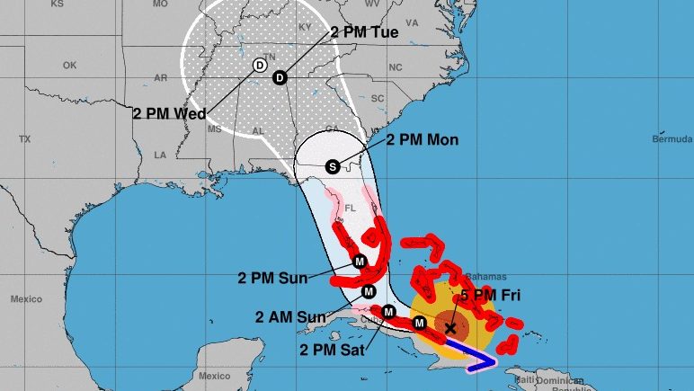
Fort Lauderdale and Broward County remain in the crosshairs of Hurricane Irma, which is currently a Category 4 . The storm is predicted to be near the southern Florida peninsula by Sunday morning and may re-strengthen to a Category 5 before it makes landfall. Tropical storm winds extend far outside the hurricane, so Florida can expect to start feeling the effects of the hurricane sooner on Saturday.
What are the latest updates for Fort Lauderdale? Here’s the key information you need to know, as of the evening of Sept. 8.
Hurricane Forecasts in Broward County
Key Messages on Hurricane #Irma as of 5:00 PM EDT:
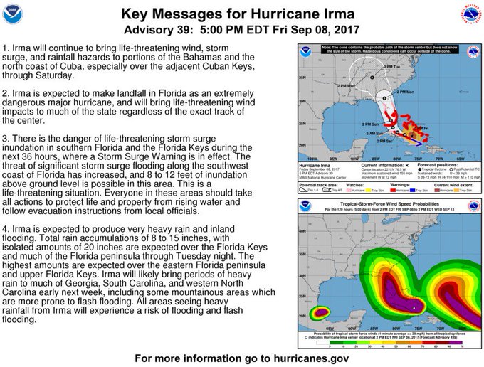

According to the National Hurricane Center’s 5 p.m. advisory, Irma is expected to make landfall in Florida and will bring life-threatening winds to the state regardless of exactly where the center of the storm makes landfall. Southern Florida and the Florida Keys are in danger of life-threatening storm surges over the next 36 hours. About 8 to 12 feet of inundation above ground is possible in the southwest coast of Florida.

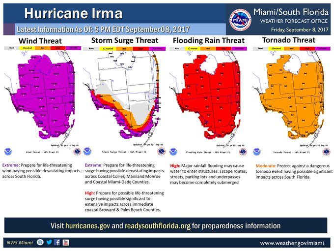
Irma is also expected to produce heavy rain of 8 to 15 inches, with isolated amounts up to 20 inches over the Florida Keys and much of the Florida peninsula through Tuesday night. The highest amounts are currently expected to be seen over eastern Florida and the upper Florida Keys.
In Broward County specifically, Mayor Barbara Sharief said on Friday that the county is expecting extensive damage from Irma, including property damage, flooding, and widespread power outages, ABC 10 reported.
As of 5:30 p.m., according to the NHC, the following local hurricane statement was issued for South Florida. It included the following:
Category 4 Hurricane Irma continues to move west northwest across the southern Bahamas this afternoon, and will impact South Florida beginning Saturday. Hurricane Irma continues to remain a severe and extremely dangerous threat for all of South Florida. Direct major hurricane landfall is likely somewhere across South Florida this weekend.
The primary concerns continue to be for catastrophic major hurricane force winds and life-threatening storm surge. Additional concerns include the potential for flooding rainfall, isolated tornadoes, significant beach erosion and surf, and life-threatening rip currents.
Depending on the eventual track of Hurricane Irma, flash flooding is also possible around portions of Lake Okeechobee in association with a possible overwash or minor to moderate overtopping of the Herbert Hoover Dike. Interests near Lake Okeechobee should heed the orders of local and state emergency management officials.
Preparations to protect life and property are strongly urged to be completed by tonight. All persons in South Florida should take shelter by early Saturday morning. Hurricane Irma is a potentially deadly situation and should not be taken lightly. Everyone is urged to exercise extreme caution in order to protect their lives.
POTENTIAL IMPACTS
—————–* SURGE:
Protect against life-threatening surge having possible devastating impacts across coastal Miami-Dade, Mainland Monroe, and Collier counties. Potential impacts in this area include:
– Widespread deep inundation, with storm surge flooding greatly accentuated by powerful battering waves. Structural damage to buildings, with many washing away. Damage greatly compounded
from considerable floating debris. Locations may be uninhabitable for an extended period.
– Near-shore escape routes and secondary roads washed out or severely flooded. Flood control systems and barriers may become stressed.
– Extreme beach erosion. New shoreline cuts possible.
– Massive damage to marinas, docks, boardwalks, and piers.
Numerous small craft broken away from moorings with many lifted onshore and stranded.Also, protect against life-threatening surge having possible significant to extensive impacts across the immediate coast of Broward and Palm Beach counties.
* WIND:
Protect against life-threatening wind having possible devastating impacts across all of South Florida. Potential impacts include:
– Structural damage to sturdy buildings, some with complete roof and wall failures. Complete destruction of mobile homes. Damage greatly accentuated by large airborne projectiles. Locations may be uninhabitable for weeks or months.
– Numerous large trees snapped or uprooted along with fences and roadway signs blown over.
– Many roads impassable from large debris, and more within urban or heavily wooded places. Many bridges, causeways, and access routes impassable.
– Widespread power and communications outages.* FLOODING RAIN:
Protect against life-threatening rainfall flooding having possible extensive impacts across South Florida. Potential impacts include:
– Major rainfall flooding may prompt many evacuations and rescues.
– Ditches and canals may rapidly overflow their banks in multiple places. Flood control systems and barriers may become stressed.
– Flood waters can enter many structures within multiple communities, some structures becoming uninhabitable or washed away. Many places where flood waters may cover escape routes. Streets, parking lots and underpasses become submerged. Driving conditions become dangerous. Many road and bridge closures with some weakened or washed out.* TORNADOES:
Protect against a dangerous tornado event having possible significant impacts across South Florida. Potential impacts include:
– The occurrence of scattered tornadoes can hinder the execution of emergency plans during tropical events.
– Several places may experience tornado damage with a few spots of considerable damage, power loss, and communications failures.
– Locations could realize roofs torn off frame houses, mobile homes demolished, boxcars overturned, large trees snapped or uprooted, vehicles tumbled, and small boats tossed about. Dangerous projectiles can add to the toll.PRECAUTIONARY/PREPAREDNESS ACTIONS
———————————-* EVACUATIONS:
Broward County: Mandatory evacuation ordered for areas east of Federal Highway, barrier islands, low-lying areas, and mobile homes.
Collier County: Mandatory evacuations of locations south and west of US 41, and those living in mobile homes.
Miami-Dade County: Mandatory evacuation of mobile homes, evacuation zone A, zone B, portions of zone C, and barrier islands which include Bal Harbour, Bay Harbour Islands, Golden Beach, Indian Creek Village, Miami Beach, North Bay Village, Sunny Isles Beach, and
Surfside.Palm Beach County: Mandatory evacuation of zones A and B, as well as mobile homes and flood-prone areas. Voluntary evacuation of zone C. Effective at 10 AM Friday.
For further information, contact 311 for Miami-Dade and Broward counties and 211 across the rest of South Florida.
If evacuating away from the area or relocating to a nearby shelter, leave early before weather conditions become hazardous.
* OTHER PREPAREDNESS INFORMATION:
Check-in with your emergency points of contact among family, friends, and workmates. Inform them of your status and well-being. Let them know how you intend to ride out the storm and when you plan to check-in again.
Keep cell phones well charged and handy. Also, cell phone chargers for automobiles can be helpful after the storm. Locate your chargers and keep them with your cell phone.
In emergencies it is best to remain calm. Stay informed and focused on the situation at hand. Exercise patience with those you encounter. Be a good neighbor and help others.
If relocating to a nearby shelter or to the home of a family member or friend, drive with extra caution, especially on secondary roads. Remember, many bridges and causeways will be closed once higher winds arrive. Also, if you encounter water covering the road, seek an alternate route. Always obey official road signs for closures and detours.
Closely monitor NOAA Weather radio or other local news outlets for official storm information. Be ready to adapt to possible changes to the forecast.
Jonathan Belles, meteorologist at FSU Weather, shared on Facebook: “Confidence is higher today that there will be major impacts of a Category 4 hurricane in Florida. Nailing down that exact landfall point and ground zero is still not possible, but Florida landfall is looking very likely.”
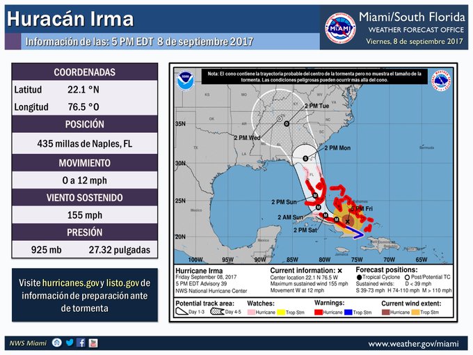
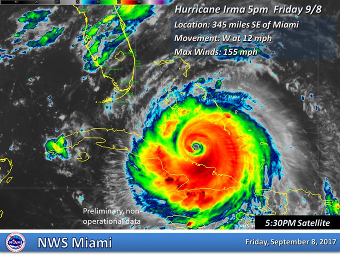
Irma is currently at 22.1 N, 76.5 W, about 345 miles southeast of Miami, with maximum sustained winds of 155 mph. Irma is moving west at 12 mph, with a turn northwest expected late Saturday. The storm should be near the Florida Keys and the southern Florida Peninsula by Sunday morning. But tropical storm winds will be felt as early as Saturday.
Fort Lauderdale’s long-range forecast, according to the National Weather Service, is:
Evacuations & Preparation
A mandatory evacuation is in place for Broward County residents living east of Federal Highway, in mobile homes, and in low-lying areas, ABC 10 reported.
You should know your evacuation zone. You can click here to find a larger PDF of the evacuation zone map.
Broward County Mayor Barbara Sharief said in a press conference on Tuesday:
If you live in an evacuation zone, determine when and where you will evacuate to. Going to stay with family outside the evacuation zone is the best choice since shelters only provide for vacant needs.”
If you’re going to a shelter, make sure you have items to keep you comfortable, like bedding, snacks, water, and medicine. If you take a pet to a pet-friendly shelter, register it online first. The original pet friendly shelter is now at capacity and a second pet-friendly shelter has been opened at Everglades High School at 17100 SW 48th Court in Miramar. Bring personal supplies, including pet food and a crate. You’ll need to take care of your pet while staying at a pet friendly shelter.
Here is a list of shelters in Broward County, as shared by ABC 10:
- Lyons Creek Middle School, 4333 Sol Press Blvd., Coconut Creek
Monarch High School, 5050 Wiles Road, Coconut Creek
Coral Glades High School, 2700 Sportsplex Drive, Coral Springs (FULL)
Fox Trail Elementary School, 1250 S. Nob Hill Road, Davie (FULL)
Rock Island Elementary School, 2350 NW 19th St, Fort Lauderdale
Atlantic Technical Center and Technical High School, 4700 Coconut Creek Parkway, Coconut Creek
Watkins Elementary School, 2310 NW 70th Terrace, Hollywood (FULL)
Park Lakes Elementary School, 3925 N. State Road 7, Lauderdale Lakes
Pompano Beach High School, 600 NE 13th Ave., Pompano Beach (FULL)
Everglades High School, 17100 SW 48th Ct., Miramar (PET FRIENDLY) - New Renaissance Middle School, 10701 Miramar Blvd.
- West Broward High School, 500 NW 209 Ave., Pembroke Pines (FULL)
- Planation Elementary School, 651 NW 42nd Ave., Plantation (FULL)
- Falcon Cove Middle School, 4251 Bonaventure Blvd., Weston
- Millennium Middle School/Challenger Elementary School Campus (PET FRIENDLY), 5803 NW 94th Ave., Tamarac (FULL)
The emergency hotline for residents in Broward County is now open. Residents can call 311 or 954-831-4000.
Sen. Marco Rubio said that all preparation and evacuations should be finished by Friday.
If you’re in an evacuation zone and don’t have a way to evacuate, call 1-800-342-3557.
If you are in an evacuation zone & do not have a way to evacuate due to traffic- call 1-800-342-3557. We will do all we can to get you out.
Floridians are asked to visit FloridaDisaster.org/GetAPlan to plan ahead for the storm.
If you’re in Broward County and want to stay updated, text ALERTBROWARD to 888-777.
If you experience a power outage, notify Florida Power & Light at 800-468-8243 or at FPL.com.