National Hurricane Center
With Hurricane Irma shifting to the west in recent forecasting models, there are growing concerns for Fort Myers and other areas of Lee County.
As a result, the National Weather Service has now issued a hurricane warning for Lee County, including Fort Myers. Right as September 9 arrived, NWS reported, “…HURRICANE WARNING REMAINS IN EFFECT…..STORM SURGE WARNING REMAINS IN EFFECT…LOCATIONS AFFECTED- Fort Myers- Lehigh Acres.”
According to NWS, “A Hurricane Warning is issued when sustained winds of 64 kt (74 mph) or higher associated with a tropical cyclone are expected in 36 hours or less. These winds may be accompanied by storm surge, coastal flooding, and/or river flooding. A hurricane warning can remain in effect when dangerously high water or a combination of dangerously high water and exceptionally high waves continue, even though winds may be less than hurricane force.”
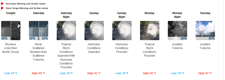
Hurricane conditions are now reported as possible in Fort Myers for Saturday night, Sunday, and Sunday night in the September 9 forecast:

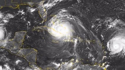
See the latest Fort Myers radar here. See the latest satellite images of Irma here. See the Fort Myers latest weather page.
Hurricane Warning
Issued: September 08 at 11:59PM EDT
Expiring: until further notice Urgency: Expected
Status: Actual
Areas affected:Coastal Lee
Hurricane Warning
Issued: September 08 at 11:59PM EDT
Expiring: until further notice Urgency: Expected
Status: Actual
Areas affected:Inland Lee
The early September 9 update for Fort Myers said, “Hurricane Irma continues to be an extremely dangerous Category 5 Hurricane. It is currently nearing landfall across the north coast of Cuba but is expected to begin moving towards the peninsula during the day Saturday. This hurricane remains an extremely dangerous threat to all of west central and southwest Florida. Preparations to protect life and property should be rushed to completion, with any last-minute preparations finished on Saturday.”
Lee county reported:
“The following shelters are open:
East Lee County High School, 715 Thomas Sherwin Ave. Lehigh Acres
Harns Marsh Elementary, 1800 Unive Ave. North Lehigh Acres
Island Coast High School, 2125 DeNavarra Pkwy. Cape Coral
Oak Hammock Middle School, Fort Myers
South Fort Myers High School, 14020 Plantation Rd. Fort Myers
Varsity Lakes MIddle School, 801 Gunnary Rd. North Lehigh Acres
The following shelters are opening 10am Saturday:
·Ray V. Pottorf Elementary, 4600 Challenger Blvd., Fort Myers
·Germain Arena, 11000 Everglades Parkway, Estero
Residents who plan to evacuate should make their preparations tonight to move quickly Saturday morning.
The Estero Recreation Center has reached its capacity as a shelter.”
The National Weather Service listed these potential impacts for Fort Myers:
POTENTIAL IMPACTS
—————–
“* WIND:
Prepare for life-threatening wind having possible devastating impacts
across West Central and Southwest Florida. Potential impacts include:
– Structural damage to sturdy buildings, some with complete roof
and wall failures. Complete destruction of mobile homes. Damage
greatly accentuated by large airborne projectiles. Locations
may be uninhabitable for weeks or months.
– Numerous large trees snapped or uprooted along with fences and
roadway signs blown over.
– Many roads impassable from large debris, and more within urban
or heavily wooded places. Many bridges, causeways, and access
routes impassable.
– Widespread power and communications outages.
* SURGE:
Prepare for life-threatening surge having possible devastating
impacts across the Tampa Bay region and all of southwest Florida. Potential
impacts in this area include:
– Widespread deep inundation, with storm surge flooding greatly
accentuated by powerful battering waves. Structural damage to
buildings, with many washing away. Damage greatly compounded
from considerable floating debris. Locations may be
uninhabitable for an extended period.
– Near-shore escape routes and secondary roads washed out or
severely flooded. Flood control systems and barriers may become
stressed.
– Extreme beach erosion. New shoreline cuts possible.
– Massive damage to marinas, docks, boardwalks, and piers.
Numerous small craft broken away from moorings with many lifted
onshore and stranded.
Also, prepare for life-threatening surge having possible significant
to extensive impacts across coastal regions of the Nature Coast. This
includes Pasco, Hernando, Citrus and Levy Counties.
* FLOODING RAIN:
Prepare for life-threatening rainfall flooding having possible
extensive impacts across west central and southwest Florida.
Potential impacts include:
– Major rainfall flooding may prompt many evacuations and rescues.
– Rivers and tributaries may rapidly overflow their banks in
multiple places. Small streams, creeks, canals, and ditches may
become dangerous rivers. Flood control systems and barriers may
become stressed.
– Flood waters can enter many structures within multiple
communities, some structures becoming uninhabitable or washed
away. Many places where flood waters may cover escape routes.
Streets and parking lots become rivers of moving water with
underpasses submerged. Driving conditions become dangerous.
Many road and bridge closures with some weakened or washed out.
* TORNADOES:
Prepare for a dangerous tornado event having possible significant
impacts across West Central and Southwest Florida. Potential impacts
include:
– The occurrence of scattered tornadoes can hinder the execution
of emergency plans during tropical events.
– Several places may experience tornado damage with a few spots
of considerable damage, power loss, and communications failures.
– Locations could realize roofs torn off frame houses, mobile
homes demolished, boxcars overturned, large trees snapped or
uprooted, vehicles tumbled, and small boats tossed about.
Dangerous projectiles can add to the toll.”