National Hurricane Center
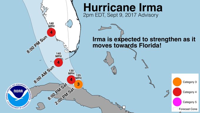
Hurricane Irma continues on its path to the U.S. mainland coast, with Florida squarely within its crosshairs according to the most recent projected paths. And now it’s taken another westerly shift, which might put Tampa more within its path. The storm is currently a Category 3 with 125 mph winds, but it could restrengthen to a Category 4 before it makes landfall in Florida. Southern Florida will start feeling hurricane conditions tonight, and Irma’s eye is expected to strike parts of the Keys by Sunday morning. A current path places the eye moving up the southwest coast of Florida by Sunday evening.
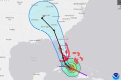
The map above shows a cone estimating the probable path of the center of Irma. It does not reflect the size of the storm, and hazardous conditions may be felt outside of this cone. The hurricane warnings are in red above, and tropical storm warnings are in blue. Hurricane watches are in pink and tropical storm watches are in yellow.
The center of the storm is currently expected to move up the west coast of Florida, from the Florida Keys to Naples and Fort Myers, and up to Tampa. At 3 p.m., Irma was 140 miles southeast of Key West, moving west at 9 mph. The hurricane’s exact position was 23.1 N and 80.3 W. The storm is expected to turn north later on Saturday, moving over the Keys and up the west coast. But hurricane tracks can move and be a bit unpredictable, so keep an eye on weather alerts for the latest updates.
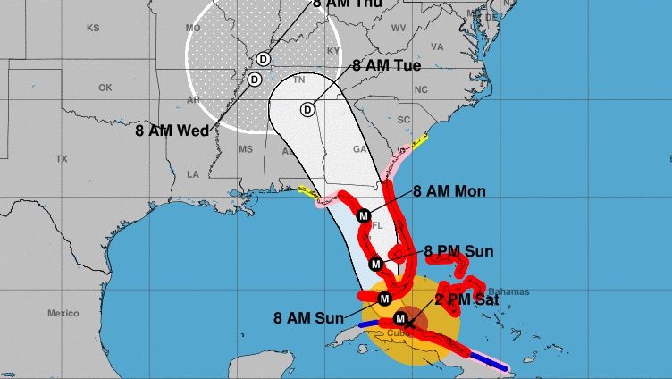
This map gives you a better idea of where the eye of the storm is currently expected and when:

And spaghetti plots are merging, all taking a westwardly trend:
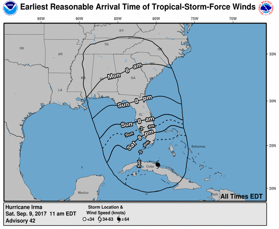
Jonathan Belles, a meteorologist, posted on Facebook that outer tropical storm force winds are expected to arrive in south Florida midday to later today, in Central Florida late Sunday morning, North Florida by Sunday evening or early Monday morning, and in Georgia or South Carolina on Monday. If you’re closer to Irma’s center, then hurricane force winds will arrive shortly after that.
Here’s an experimental map showing when tropical storm force winds will be felt. As you can see from the map, southernmost Florida is already feeling tropical storm winds, which will be extending up the Florida coast through Sunday. Georgia will begin feeling tropical storm winds by Sunday night or Monday morning.
National Hurricane Center
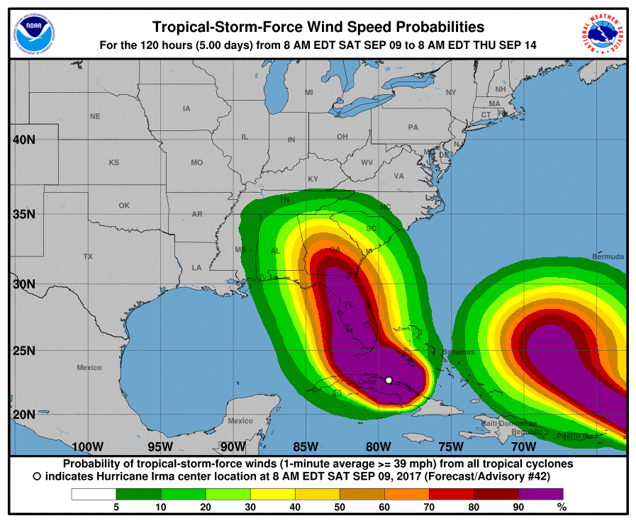
Wind speed probabilities can be viewed in this map:
National Hurricane Center
The wind speeds you’re seeing to the right are from Hurricane Jose. These probabilities are for 8 a.m. Eastern Saturday through 8 a.m. Eastern on Thursday.
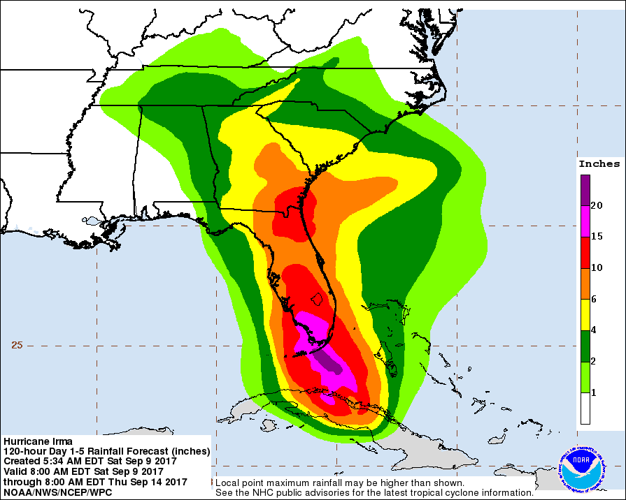
You might also be interested in seeing rainfall potential maps for Irma, from the National Hurricane Center. This map below estimates rainfall potential from Saturday morning through Thursday morning. According to this latest estimate, the southernmost part of the Florida peninsula is estimated to get 15 to 20 inches of rain, and different parts of the state will see 10 to 15 inches, depending on the hurricane’s track.
National Hurricane Center
Next is a map of storm surge predictions for Irma:
Storm Surge forecast Cape Sable to Captiva:10-15 ft!Captiva to Ana Maria Island:6-10 feet;Ana Maria to Clearwater including Tampa Bay:5-8 ft

Irma’s current pressure is 938 mb, which is the same pressure Harvey had:
#Irma‘s current pressure is 938 mb – the exact same landfalling pressure that Harvey had ~2 weeks ago.
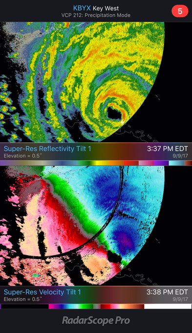
Irma’s center is fully visible in radar images:
The center of Irma is now fully visible from @NWSKeyWest‘s radar.
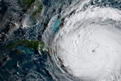
And here’s a satellite view of the eye:
#Irma‘s eye has emerged from the north coast of Cuba, and it looks to be beginning its inexorable turn towards the WNW.
Here you can see the path of Irma since it formed, from NASA’s CloudSat:
Video: Powerful #HurricaneIrma Seen in 3D by NASA’s CloudSat
t.co/QISrgZ5UTr
Watch Irma live with these videos below:
Learn more about the latest Irma models below: