Hurricane Irma is a Category 5 packing 185 mph winds and could be one of the biggest storms in recent history. Although Irma may not make a possible landfall on the U.S. coast until this weekend, many people in parts Florida are already evacuating. Palm Beach County is currently in the hurricane’s possible track and has declared a State of Emergency. But hurricanes are notoriously tough to predict, so the storm’s exact path won’t be known quite yet. The hurricane has already left extensive destruction in its wake, as it tore through areas like the tiny island of Barbuda, which was left with 90 percent of its structures damaged. Now it’s heading to the Dominican Republic and the Bahamas, moving at about 16 mph.
Here’s everything we know so far about the hurricane’s potential impact in West Palm Beach.
Hurricane Irma & West Palm Beach
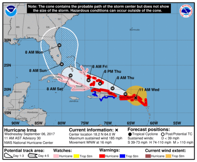
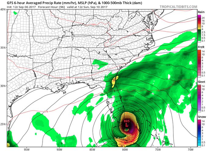
At 5 p.m., the National Hurricane Center in Miami released its latest projection for Hurricane Irma:
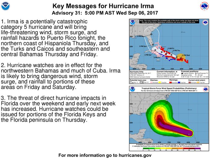
Unfortunately, the latest 5 pm advisory stated:
The threat of direct hurricane impacts in Florida over the weekend and early next week has increased. Hurricane watches could be issued for portions of the Florida Keys and the Florida peninsula on Thursday.”
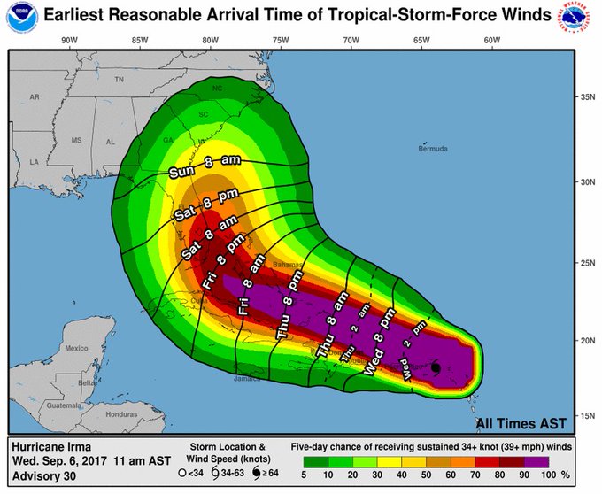
And here are the latest estimates on when to expect tropical storm force winds:
Irma is located at 18.8 N and 65.4 W as of 5 p.m., the National Hurricane Center reported, about 55 miles ENE of San Juan Puerto Rico, with maximum sustained winds of 185 mph, moving WNW at 16 mph.
Governor Rick Scott has already declared a State of Emergency to prepare for the storm in Florida.
Meanwhile, West Palm Beach and Palm Beach County residents are preparing for the hurricane’s arrival. Demolition crews are clearing their sites in downtown West Palm Beach. Cranes will be set to swivel with the wind so they don’t snap, Palm Beach Post reported.
Evacuations Haven’t Been Issued Yet, But Know Your Zone in Case They Are
At the time of publication, evacuations hadn’t been issued yet for West Palm Beach, the Palm Beach Post reported. Mayor Jeri Muoio tweeted that a decision will likely come Thursday since they’re still determining the path of the storm.
Residents are urged to know their evacuation zones in case an alert goes out. If you aren’t sure which evacuation zone you’re in, you can visit here to find out. If the city orders an evacuation, you should leave, officials have said, because emergency responders can’t help you in the middle of a hurricane. Evacuations are only ordered because of a threat of flooding, not wind, emergency managers have said.
Palm Beach Post reported that at this point, driving is likely the only option for evacuating, since most flights out of Palm Beach, Fort Lauderdale and Miami are booked. In southern Georgia, hotel rooms are getting tough to find, so the further north that evacuees go, the better.
But gas is getting tough to find, so you’ll want to conserve your fuel if you’re thinking of leaving. Palm Beach County emergency managers said today that demand for fuel is outpacing supplies, so residences are being advised to shelter within their county.
Here Are the Shelters in Palm Beach County
West Palm Beach’s Emergency Operations Center will open Thursday and be in full activation mode by Friday, Palm Beach Post reported.
According to the Sun-Sentinel, the following 15 shelters are available starting at 10 a.m. Friday in Palm Beach County:
Atlantic High School, 2455 W Atlantic Ave. in Delray Beach; Boca Raton High School, 1501 NW 15th Court; Boynton Beach High School, 4975 Park Ridge Blvd.; Dr. Mary McLeod Bethune Elementary School, 1501 Avenue U in Riviera Beach; Forest Hill High School, 6901 Parker Ave. in West Palm Beach; Independence Middle School, 4001 Greenway Drive in Jupiter; John I. Leonard High School, 4701 10 Ave. in Greenacres; Lakeshore Middle School, 425 W. Canal St. N. in Belle Glade; Palm Beach Central High School, 8499 Forest Hill Blvd. in Wellington; Palm Beach Gardens High School, 4245 Holly Drive; Park Vista High School, 7900 Jog Road in Lake Worth; Pahokee Middle School, 850 Larrimore Road in Pahokee; Seminole Ridge High School, 4601 Seminole Pratt Whitney Road in Loxahatchee; West Boca High School, 12811 Glades Road; and Westgate Elementary, 1545 Loxahatchee Drive in West Palm Beach. Residents going to shelter need to bring their own water, clothes and medication.
In addition, a pet-friendly shelter opens 10 a.m. Friday at West Boynton Recreation Center, 6000 Northtree Blvd. in Lake Worth. It’s only available to Palm Beach County residents in a mandatory evacuation zone or in mobile homes. Proof of residency is required. Each pet must be accompanied by only one owner and other family owners must stay elsewhere.
Experts are urging caution about paying too much heed to the storm’s track and landfall, since it’s 120 miles across (nearly as wide as Florida itself) and many areas will feel the impact of the storm even if they aren’t directly hit by the center of the storm. Tropical storm force winds will extend out 160 miles.
Here’s the current long range forecast for West Palm Beach, according to the National Weather Service. This could change as the hurricane’s path becomes more predictable.
Floridians are asked to visit FloridaDisaster.org/GetAPlan to plan ahead for the storm.
If you want to sign up for local alerts from Palm Beach County, download the Palm Beach County’s PBCDart and the City’s Code Red apps. You can also follow the city of West Palm Beach at twitter at @westpalmbch, the police department at @WestPalmPD, and the website at wpg.org/storm.


