National Hurricane Center
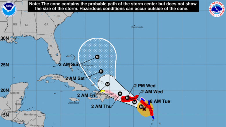
Hurricane Maria is a Category 5 storm raging in the Caribbean, disrupting several islands in her path and leaving severe destruction in her wake. Maria is currently 115 miles west of Guadeloupe, heading straight for Puerto Rico. The whole island is expected to experience a “buzzsaw” effect, as Maria’s eye is tracking directly through the center.
It has been 85 years since a Category 4 or 5 hurricane has made landfall in Puerto Rico. Governor Ricardo Rosselló has declared a state of emergency for all of Puerto Rico.
“This is an event that will be damaging to the infrastructure, that will be catastrophic. Our only focus right now should be to make sure we save lives. We expect to feel storm winds, tropical storm winds, (from) Tuesday up until late on Thursday. That’s about two-and-a-half days of tropical storm winds,” Rosselló told CNN. He also said that 500 shelters are open to the public.
San Juan is expected to feel severe impacts from Maria. Puerto Rico’s capital (and its largest city) is located on the northern coast of the island.
Although Puerto Rico dodged a bullet when Hurricane Irma raged to the north as a Category 5, the island is preparing for one of the worst storms it has ever seen. Maria will bring damaging winds topping 155 mph with even higher gusts to the area within the next 24 hours. In addition, Maria will bring incredible amounts of rain. Some areas will see as much as two feet of rain fall by Thursday.
“The National Weather Service office in San Juan, Puerto Rico, warned of ‘catastrophic damage’ from Maria’s winds, as well as the potential for ‘devastating to catastrophic flooding’ from rainfall flooding in a hurricane local statement issued Tuesday morning,” The Weather Channel reported.
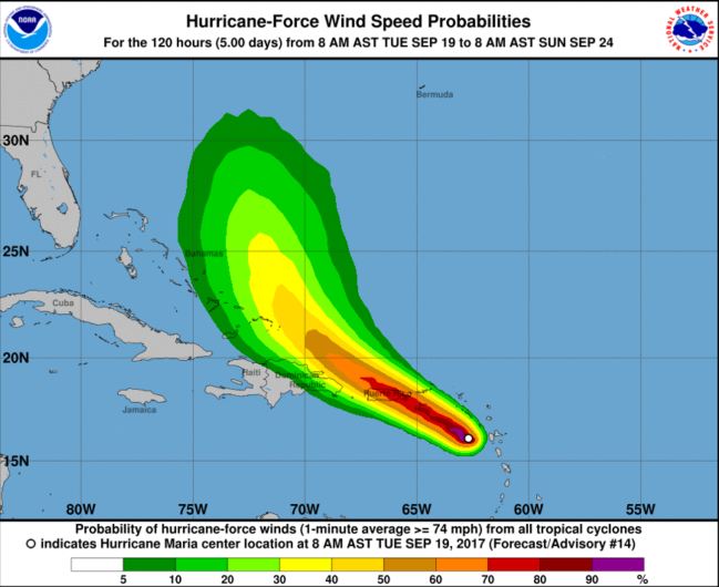
Winds are expected to pick up in intensity in the overnight hours tonight. As you can see in the map below, most of Puerto Rico is set to experience hurricane force winds.

The storm surge in Puerto Rico is expected to be 6 to 9 feet. Severe flooding is expected in many coastal areas.
“The deepest water will occur along the immediate coast near and to the north and east of the landfall location, where the surge will be accompanied by large and destructive waves. Surge-related flooding depends on the relative timing of the surge and the tidal cycle, and can vary greatly over short distances,” the National Hurricane Center said in their 11 a.m. advisory.

