National Hurricane Center
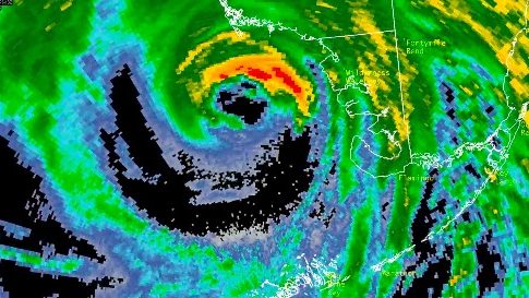
Hurricane Irma, now a still-powerful category 3 storm, was making landfall along Florida’s southwestern coast in the area of Naples and Marco Island. Other communities in the area, like Fort Myers, were also in immediate peril around 3 p.m. on the east coast. By 5 p.m., the hurricane had made its second landfall along Marco Island and was five miles from Naples.
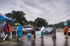
People were already posting videos and photos from the scene in Naples.
This is how the monstrous storm looked as it approached Naples. According to CNN, at 3 p.m., “Naples and Marco Island will endure some of the strongest winds in the next few hours.”
My Gif of wind velocity and direction from @myradar as #hurricaneirma2017 approaches #Naples #Flwx
Recorded by DU Recorder
The National Hurricane Center warned: “The threat of catastrophic storm surge flooding is highest along the southwest coast of Florida, where 10 to 15 feet of inundation above ground level is expected. This is a life-threatening situation.”
Here are some of the other photos and videos that people are posting from the scene of the hurricane’s landfall (it also landed in the Florida Keys earlier on Sunday morning):
Heavy winds were seen in the area, although the threat from storm surge was perhaps even more dire. Trees were snapping. The gusts were reported in excess of 80 mph and there was a significant debris field, according to CNN.
#HoyMismo El Centro Nacional de Huracanes informa que el ojo del #HuracanIrma se aproxima a Naples, Florida.
Some flooding was also being experienced already.
t.co/OGBVc8QyTB Aquí una webcam en Naples, Florida. Por donde se supone que pasará el ojo de #Irma #HuracanIrma
Another stream south of Naples. Looks at those winds sweeping across the landscape. t.co/ZbvG7qOV1H #Irma
9-10-2017 Naples, FL – Downed Trees Snapped Powerlines High Wind t.co/HVTywZ1VuZ via @StormwallVideos
https://twitter.com/_Aca_Noticias/status/906954614301450240
El huracán Irma azota con fuerza a Florida (En vivo desde Miami, Naples y West Palm Beach)

RT – FoxNews – National Hurricane Center: The Center of “dangerous” #HurricaneIrma is approaching Naples.
By 2 p.m., the storm was already looming over southwestern Florida. This was its position then:
LOCATION…25.6N 81.8W
ABOUT 35 MI…55 KM S OF NAPLES FLORIDA
ABOUT 70 MI…115 KM S OF FT. MYERS FLORIDA
MAXIMUM SUSTAINED WINDS…120 MPH…195 KM/H
PRESENT MOVEMENT…N OR 350 DEGREES AT 12 MPH…19 KM/H
MINIMUM CENTRAL PRESSURE…936 MB…27.64 INCHES
Follow the hurricane’s progress on the National Hurricane Center’s site here. Many had projected that the storm would make its second landfall in Naples for at least a day after it started to shift to the west.
“We’ve already started to see trees falling down and that’s only going to get worse,” says @edlavaCNN in Naples, FL t.co/UV2TbA0lY0
Here is a roundup of sites you can use to track the hurricane’s path in real time: