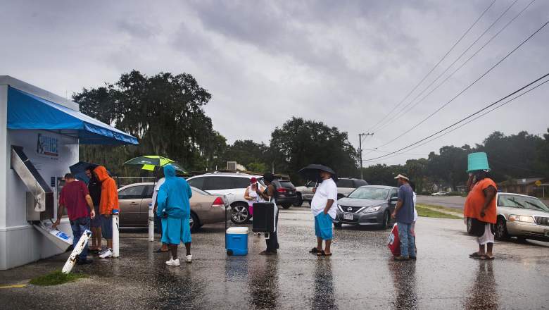
Getty] Geoff Rutland (L), a local volunteer from Crossing Jordan Church, helps other residents get ice from a vending machine in Tampa, Florida, on September 10, 2017, where residents are fleeing the evacuation zones ahead of Hurricane Irma's landfall.
Hurricane Irma made its second landfall along Marco Island and then the Naples area. However, where is the storm on Monday?
See videos of the hurricane and scene as its presence started being felt in Naples after 3 p.m. Sunday.
The storm’s location changes by the second, obviously. How can you track the storm in real time with maps, satellites, and the like? There are a lot of great resources where you can get the most updated real-time images right now.
Here are some of the best sites you can use to track Irma in real time:
National Hurricane Center & National Weather Service

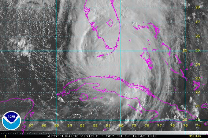
These are the sites that the news media most heavily rely on, and they’ve got constant updates on the storm. NHC also has updated satellite imagery. Here’s another look.
At 2 p.m, NHC reported of the storm’s location:
LOCATION…25.6N 81.8W
ABOUT 35 MI…55 KM S OF NAPLES FLORIDA
ABOUT 70 MI…115 KM S OF FT. MYERS FLORIDA
MAXIMUM SUSTAINED WINDS…120 MPH…195 KM/H
PRESENT MOVEMENT…N OR 350 DEGREES AT 12 MPH…19 KM/H
MINIMUM CENTRAL PRESSURE…936 MB…27.64 INCHES
The National Weather Service also has a page with updated, thorough information on Irma. This is a great resource page from NWS that has a lot of real-time imagery, maps and the like. If you click on the “threats and impacts” tab, you can see maps you can customize for different areas of Florida to see local projections for things like wind speed and rainfall. Don’t forget to click through the other tabs at the top of the page at that link, such as for satellites, if you are looking for real-time movement of the hurricane.
Here’s a real-time U.S. infrared.
You can also search for any community in the U.S. in the National Weather Service page and get updated real-time maps for the weather in the area. For example, here’s Tampa. Just enter city, state or zip code in the top left box.
NOAA
#GOES16 captured this geocolor loop of #Irma making landfall in the Florida Keys this morning. Latest Irma info @ t.co/cSGOfrM0lG
The National Oceanic and Atmospheric Administration has some pretty stunning imagery of the storm. NOAA also has a data exploration tool. You can even map the historical tracks of all hurricanes here.
See colorized infrared images of the storm that you can update with your cursor.
The Weather Channel & CNN
Our live location on @weatherchannel w/ @JimCantore during #HurracaineIrma in Ft Myers (video via @AtlantaDrone) @LeeCountyEOC
The Weather Channel has an interactive hurricane tracking real-time map.
CNN has an Irmer tracker too.
Cyclocane & Weather Underground
Cyclocane has a lot of real-time maps including satellite and spaghetti models. The Cyclocane site will also give you data such as the storm’s current status.
Weather Underground also offers a lot of real-time maps.
South Florida Waste Management District
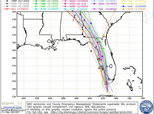
Central Florida Waste Management DistrictSunday morning spaghetti model.
This government site has a regularly updated spaghetti model of the storm’s path. See the map here.
UW-Madison & National Center for Atmospheric Research
NCAR’s Tropical Cyclone Guidance Project has a lot of real-time data and maps, including spaghetti models, here.
The University of Wisconsin-Madison is also doing real-time tracking. Click on the yellow hurricane symbol for Irma to see more at this page.
Local TV
Some local TV stations have live feeds you can watch. Here’s one.
CBS Miami is live in the thick of things.
If you’re looking for live radar videos and feeds, here’s a good round up: