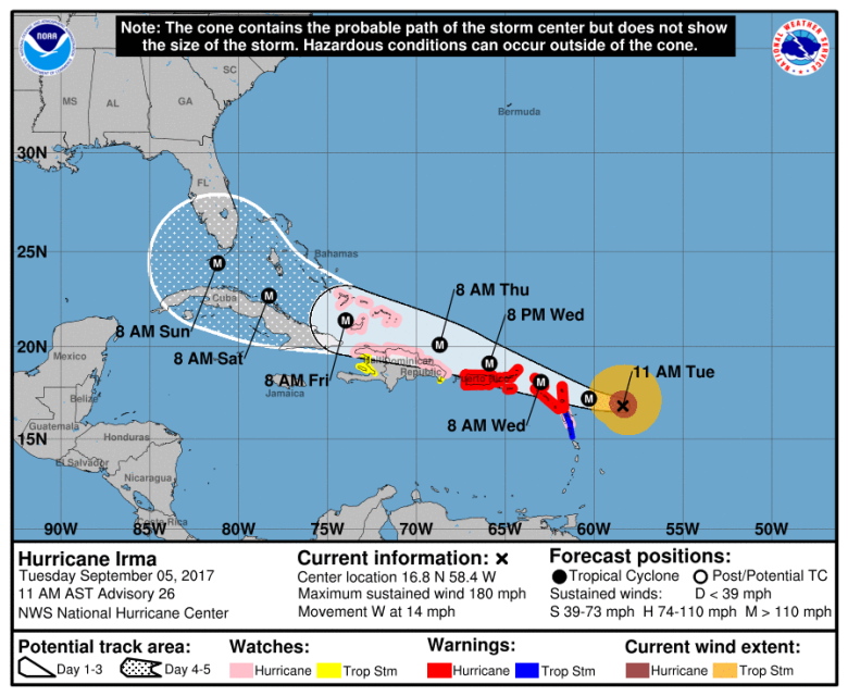
NOAA NOAA's map of Hurricane Irma as of 11:00 a.m. AST.
Hurricane Irma is slowly approaching the United States and is bringing Category 5 conditions along with it. The National Hurricane Center is urging those in its path to take proper precautions and be wary and vigilant of the storm’s movement as it nears southern Florida.
While it’s still too early to determine the exact path the storm will take, many meteorologists are projecting it to hit the Florida Peninsula and move to the northeast. Though some individual hurricane models show it could still shift to the opposite direction once it reaches Cuba and move toward Florida’s panhandle.
Either way, those residing in Tallahassee are being told to brace for the effects of the hurricane, regardless of if it’s directly in its path or not.
“It’s safe to say that the southeast United States, including the Florida panhandle, Georgia and the Carolinas, should also brace for potential impacts, such as flash flooding, storm surge and strong winds,” The Washington Post reported.
There’s still a lot of unknowns for the storm until it moves closer to the U.S., but there are some things that are for sure. One of those is that Irma is a Category 5 storm with sustained winds in excess of 175 mph.
The NHC also said that with reported winds of 180 mph, Irma is “the strongest hurricane in the Atlantic basin outside of the Caribbean Sea and Gulf of Mexico in NHC records.”
Several models indicate that Irma will pass between the Bahamas and Cuba before making a turn and heading toward Florida. According to The Tallahassee Democrat, the easternmost model shows the storm “literally grazing” Miami with its eye by Sunday morning before moving to the north.
It’s important to note that it’s still very early in the projection phases of Irma, but its quick growth in the Atlantic Ocean indicates one of the strongest storms in recent memory. Though there’s no guarantee it will make landfall in the U.S. as of yet.
But early models show that if Irma were to make landfall in Florida, it would most likely start in Miami and move to northeast. Taking that into account, it appears that the Tallahassee area and much of Florida’s panhandle would avoid the main path of the storm. However, other models of Irma’s potential path say otherwise.
The reason there are so many differing updates at the moment is because it’s extremely difficult and nearly impossible to track the exact path of a hurricane more than four days in advance.
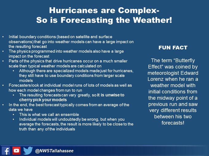
Either way, those panhandle cities could still feel the affects of the storm, such as strong winds and heavy rainfall. But many hurricane projection models are inaccurate and misleading. Therefore, the National Weather Service tweeted a fact sheet to show why you can’t trust individual models.
With a storm of this magnitude, it’s important to stay alert and be prepared regardless of which area in Florida you live in. And as Irma’s continued to grow and inch closer to the U.S., Florida Governor Rick Scott has tried to do just that. On Monday, he declared a state of emergency so that “local governments have ample time, resources and flexibility to get prepared for this dangerous storm.”
“In Florida, we always prepare for the worst and hope for the best and while the exact path of Irma is not absolutely known at this time, we cannot afford to not be prepared,” Scott said in a statement.
Many residents in Tallahassee have heeded Scott’s warning. A line for water was seen outside of a Costco on Tuesday morning, and it’s flying off the shelves as people prepare for the storm to hit.
In addition, Tallahassee officials are preparing for the potential of an influx of evacuees heading north to seek refuge in the city.
For more updates on Irma, click here.


