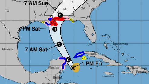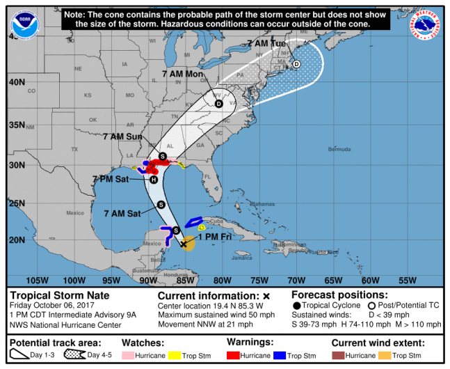
Tropical Storm Nate is predicted to hit the Gulf Coast Saturday night, including Pensacola and the rest of the Florida Panhandle. In preparation for the storm, which is also expected to become a Category 1 Hurricane before it makes landfall near New Orleans, Florida Governor Rick Scott has already issued a state of emergency for panhandle counties. Here’s a look at the latest forecast for Pensacola.

NOAA/NHCTropical Storm Nate forecast as of 1:00 p.m. CDT.
The 1:00 p.m. CDT forecast from the National Hurricane Center on October 6 shows Nate just off the coast of Louisiana by 7 p.m. Saturday, October 7. By that time, it is predicted to develop into at least a Category 1 hurricane. This means maximum sustained winds between 74 mph and 95 mph.
The 1:00 p.m. CDT public advisory reports that a Tropical Storm Watch is in effect for “East of the Okaloosa/Walton County Line to Indian Pass, Florida.” A Storm Surge Watch is also in effect for “East of the Alabama/Florida border to Indian Pass Florida.” A Tropical Storm Watch “means that tropical storm conditions are possible within the watch area, generally within 48 hours,” according to the NOAA.
It is a fast-moving storm, moving north-northwest at 21 mph with maximum sustained winds at 50 mph by Friday afternoon.
As the storm began to develop, Scott declared a state of emergency in Escambia, Santa Rosa, Okaloosa, Walton, Holmes, Washington, Bay, Jackson, Calhoun, Gulf, Gadsden, Liberty, Franklin, Leon, Wakulla, Jefferson, Madison, Taylor, Hamilton, Suwannee, Lafayette, Dixie, Columbia, Gilchrist, Levy, Baker, Union, Bradford, and Alachua counties. Pensacola is the county seat of Escambia County, which is the westernmost county in Florida and borders Alabama.
“I have declared a state of emergency for 29 counties in Florida to make certain that state, federal and local governments are able to work together and ensure resources are dispersed to local communities,” Scott said on October 5. “By declaring an emergency in these counties, we can also ensure that there is no hindrance in the transportation of supplies and assets.”
Florida residents can use FloridaDisaster.org/GetAPlan to create their own hurricane preparedness plan.
According to the Pensacola News Journal, the Escambia County Emergency Operations Center is fully operational. County officials will also determine by Friday if they need to issue evacuation orders.
Here’s the seven-day forecast for Pensacola, from the National Weather Service:
Friday Afternoon: A 30 percent chance of showers and thunderstorms. Partly sunny, with a high near 85. East wind 10 to 15 mph, with gusts as high as 20 mph.
Friday Night: A 30 percent chance of showers and thunderstorms, mainly after 1am. Mostly cloudy, with a low around 77. East wind around 10 mph.
Saturday: Showers and possibly a thunderstorm. High near 84. East wind around 15 mph, with gusts as high as 20 mph. Chance of precipitation is 80%. New rainfall amounts between a quarter and half of an inch possible.
Saturday Night: Tropical storm conditions possible. Showers and possibly a thunderstorm. Low around 78. Chance of precipitation is 80%.
Sunday: Tropical storm conditions possible. Showers and possibly a thunderstorm. High near 82. Chance of precipitation is 80%.
Sunday Night: A 40 percent chance of showers and thunderstorms. Cloudy, with a low around 77. South wind 10 to 15 mph, with gusts as high as 25 mph.
Monday: A 40 percent chance of showers and thunderstorms. Mostly cloudy, with a high near 85. South wind around 10 mph.
Monday Night: A 20 percent chance of showers and thunderstorms. Mostly cloudy, with a low around 75. South wind around 5 mph.
Tuesday: A 20 percent chance of showers and thunderstorms. Partly sunny, with a high near 86. West wind around 5 mph becoming south in the afternoon.
Tuesday Night: A 20 percent chance of showers and thunderstorms. Mostly cloudy, with a low around 71.
Wednesday: A 20 percent chance of showers and thunderstorms. Partly sunny, with a high near 84.
Wednesday Night: Partly cloudy, with a low around 67.
Thursday: Sunny, with a high near 82.