Fires continue to grow in California during the dry, hot summer months. On July 28-29, the Cranston fire is one of the largest problems, forcing thousands to evacuate, but other fires like the Carr Fire and the Ferguson Fire are also issues. Read on to learn all the details about the current fires in California as of July 28 and midnight July 29, with maps of the larger fires around the state, their current containment levels, and where they are located. News is constantly changing, so call your local officials if you are concerned about evacuations near you.
General Map of California Fires
This map below is an interactive map of some of the bigger fires in California, constantly being updated, provided by CAL FIRE and Google. Fires in red are active and fires in black are contained. Read the next section for details about the fires listed on the map.
The California Governor’s office has another active fire map for comparison, which is embedded below. This map periodically is made available only to those with a login, so if it’s not available when you’re reading this story, it might be released to the public again later.
Below is another active fire map from Google’s Crisis Map. Zoom in to areas of interest.
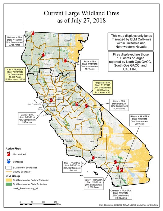
And another map from the Bureau of Land Management:
Next are more specific details on the fires as of the evening of Saturday, July 28 to around midnight Pacific July 29.
List of Active Fires in California as of July 28-29
Here are the active fires and updates about them, per CAL FIRE. Most of these are in alphabetical order, but newer fires not yet listed on the CAL FIRE map may be included in a separate section at the end.
Balch Fire
This fire is off Balch Park Road and Yokohl Drive, northeast of Porterville in Tulare County. It’s 100 acres and 80 percent contained as of Saturday night.
Carr Fire
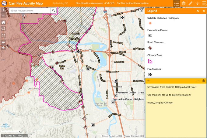
You can track the Carr fire with this interactive map from Google above, which includes road closures, evacuation centers, and more.
This fire is off Highway 299 and Carr Powerhouse Road in Whiskeytown (Shasta County.) It’s now 83,800 acres (up from a little over 40,000 acres on Friday) and 5 percent contained. 536 structures have been destroyed and 117 are damaged. The fire was caused by a vehicle’s mechanical failure.
The following evacuation orders are in place, according to CAL FIRE:
Community of French Gulch
SR 299 west of Trinity Mountain Rd to the base of Buckhorn Summit
Whiskey Creek Rd to include the boat launch/day use areas
South along Swasey Dr from SR299 to Placer Rd
West along Placer Rd from Swasey Dr to Prospect Dr
North from Prospect Dr to encompass Middle Park Ranch Land Area
West of Overhill Dr and North of SR 299
North of SR 299 and West of Spinmaker Rd to the end of Harlan Dr
Keswick Dam East to Counter Lane, North to quartz Hill Rd
North of Sacramento River to Keswick Dam Rd, West of Market Street and Lake Blvd to Keswick Dam
North at Lake Blvd and Oasis Rd to Pine Grove Ave and Walker Mine Rd west of Cascade Rd/ I-5
Pine Grove Ave North on Lake Blvd to Shasta Dam incorporating Summit City, North Belt Line and Flannigan Rd Intersection of Placer Rd and Buenaventura Blvd west to Thompson Lane
Buenaventura Blvd from Placer Rd to Westside Rd
Westside Rd to Keyon Drive incorporating Country Heights and West Redding neighborhood
Buenaventura Blvd to SR 299 to Placer Rd
Placer Road from Buenaventura Blvd to Cloverdale Rd
Cloverdale Rd from Placer Rd to Clear Creek Rd
Clear Creek Rd West from Cloverdale Rd to Honey Bee Rd
Shasta Dam Visitor Center
All of Shasta Dam Blvd
All of Shasta Lake City
Placer Rd from the Clear Creek Bridge to Clear Creek Rd
Placer Rd at Platina Rd to Buell Rd which includes South Fork Rd, Zogg Mine Road, Jenny Bird Lane, Horse Canyon Rd and all residents West of Platina Rd between Placer Rd and Buell Rd
All areas on South Fork Road from Zogg Mine Rd to South Fork Road to include the areas of Bender Rd, Serenity Dr and Serenity Way
Hwy 299 at Trinity Dam Road west to Douglas City.
Trinity Dam Road Blvd to Hwy 3 including all residences within Lewiston area to Trail Drive, Biggers Road, Steel Bridge Road, Lower Steel Bridge Road, Poker Bar Road, River Road, Quad P Road, Bridge Road, Red Lane, Old Highway, Lewiston Road, Ohio Lane, Lowden Way, Ponderosa Pines, River Front Road, Wellock Road, S. Ponderosa Pine, Coffin Road, Dirt Road, Benvenuto Way, Browns Mountain Road, Mountain Springs Road, Jobe Way, Steelhead Circle, Rebel Road, Quail Point Road, Lockhart Ranch Road, Prut Road, Upper Salt Flat Road, Salt Flat Road, Goose Ranch Road, Dredger Lane, Bacham Lane, Partridge Lane, Shady Lane, River Rock Road, Old Oak Road, Gulch Road and Lewiston Turn Pike Road
All roads and streets west of Trinity Dam Blvd and east of Lewiston Road Deadwood Road east of Trinity Dam Blvd.
All residences on Baker Road including Cooper Gulch, Posey Road, Lakeview Terrace and Pine Cove Marina including Eagle Mountain Road
Evacuation centers:
CAL FIRE:
Shasta College, 11555 Old Oregon Trail in Redding
Simpson University, 2211 College View Drive in Redding
Cross Point Community Church, 2960 Hartnell Ave in Redding
Trinity High School, 321 Victory Lane Weaverville, CA 96093
Animal evacuation centers:
- Large Animal – Redding Rodeo Grounds 715 Auditorium Drive Redding, Ca.
- Small Animal – Haven Humane 9417 East Side Drive Redding, Ca.
- Large Animal Evacuation Center: Tehama County Fairgrounds 650 Antelope Blvd Red Bluff, CA 96080 (530)945-4993
- Haven Humane, Anderson Factory Outlet 1816 CA-273 Anderson, CA 96007 (530)241-2650
Road closures: See this webpage for an extensive list of road closures.
This fire has been particularly devastating, with two firefighters killed while battling the fire.
Per CAL FIRE: “For information on evacuation notifications visit http://www.shascom911.com. Click for the most up to date evacuation orders and advisories at the Shasta County Sheriff’s page.”
Cranston Fire
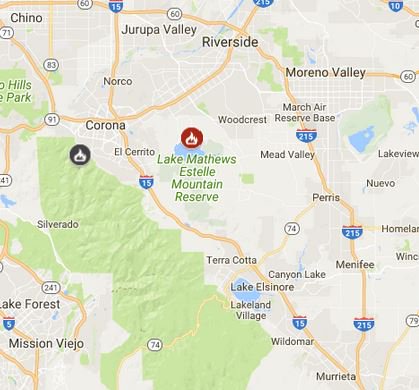
This updated, interactive map on Google Maps above shows you the location of the Cranston Fire, the location of the evacuation centers, and the closed highways. You can also see the location of the Ribbon Fire, which is near the Cranston Fire.
This map below, from Inciweb, is zoomed into the location of the Cranston fire. If you click on the Cranston fire itself, you’ll see details about the fire on the right side of the map. (The location of the details might be different on mobile.)
This fire is off Highway 74 and Control Road. Brandon McGlover was arrested and charged with starting this and four other fires in the area. It’s grown from 4,700 acres on Thursday to 13,118 acres and 29 percent contained on Saturday. 2,174 homes were evacuated and 3,200 people.
The following evacuations have been conducted by the Riverside Sheriff’s station, according to Inciweb as of Saturday evening, July 28:
- Apple Canyon Area
- Cedar Glen
- Camp Scherman Girlscout Camp
- Fern Valley
- Garner Valley
- Hurkey Creek Area
- Idyllwild
- Lake Hemet Area
- Mountain Center Community
- Mt San Jacinto State Park
- Pine Cove
An evacuation warning is in place for Paradise Corner.
According to Inciweb on Saturday, July 28: “The evacuation order is lifted for Garner Valley, south of Morris Ranch Rd. Proof of residency required. Road access is available from Highway 74 at Highway 371. All other evacuation orders remain in effect. Use caution returning home. Garner Valley residents returning home from the Cranston Fire, losing power means your perishable food is not safe. Don’t risk your family’s health, throw it out!”
An evacuation center is set up at Banning High School.
The following road closures are in place:
- HWY 74 from City of Hemet to Lake Hemet
- HWY 243 from Banning to intersection of 243 and HWY 74
The following recreation closures are in place:
Mt. San Jacinto State Park
- Desert View Trail
- Little Round Valley Campground
- Long Valley Trail
- Mountain Station
- Palm Springs Aerial Tramway
- Round Valley Campground
- Round Valley Trail
- San Jacinto Peak Trail
- Strawberry Junction Campground
- Tamarack Valley Campground
- Wellmans Divide Trail
San Bernardino National Forest
- Black Mountain Group Campground
- Boulder Basin Campground
- Cedar Springs Trail 4EI7
- Dark Canyon Campground
- Deer Springs Campground
- Deer Springs Trail to Suicide Rock 3E17 to 3E33
- Devil’s Slide Trail
- Ernie Maxwell Scenic Trail 3E07
- Fern Basin Campground
- Fobes Trail 4E04
- Fuller Ridge
- Humber Park
- Hurkey Creek Campground
- Lake Fulmor Day Use Area
- Lake Hemet Picnic Area
- Little Round Valley Campground
- Marion Mountain Campground
- Pacific Crest Trail (PCT) N of State Highway 74
- San Jacinto Wilderness
- Seven Pines Trail 2E13
- Skunk Cabbage Trail 3E42
- South Ridge Trail 3E08
- Spitler Peak Trail 3E22
- Stone Creek Yellow Post Sites
- Strawberry Creek
- Tahquitz Peak Fire Lookout
The following animal shelters are available, according to Inciweb:
Residents can call 951-358-7329 for direct assistance with moving animals.
San Jacinto Valley Animal Campus at 581 S. Grand in San Jacinto is accepting all animals, both domestic and large and small animals.
The following 3 locations were also listed Friday but are no longer listed on Saturday, so if you were going here you might want to call first:
- Large animals can be dropped off to Dysart Equestrian Park – 2101 W Victory Ave in Banning.
- Small Animals can also be dropped off at Dysart Equestrian Park – 2101 W. Victory Ave. in Banning. Animal Services will transfer them to the San Jacinto Valley Animal Campus.
- Coachella Valley Animal Campus located at 72050 Pet Land Place in Thousand Palms is open for small animals only.
There are several sources you can tune into for continuing updates about the Cranston fire.
- San Bernardino NF Facebook
- San Bernardino NF Twitter
- Riverside Sheriff’s station: Call 951-791-3400 with questions (or 911 if you’re concerned about evacuations in your area)
- Inciweb’s Cranston Fire webpage
Here are photos of the fire:
Crestline Fire
This fire is at Crestline Road and Hunt Road in Montgomery Creek in Shasta County. It’s 51 acres and 95 percent contained.
Eagle Fire
This fire is at County Road 40/County Road 1, southwest of Eagleville in Modoc County. It’s 2,100 acres and 95 percent contained, located at 41.285 latitude, -120.115 longitude. The fire is no longer be updated by Inciweb.
Ferguson Fire (Yosemite Fire)
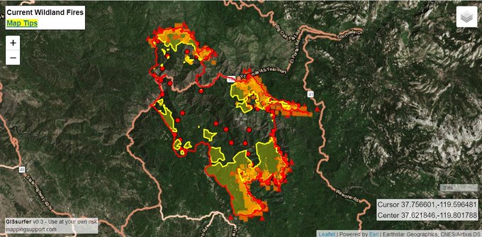
This fire is off Highway 140 and Hite Cove, near El Portal in Mariposa County. It’s burning west of Yosemite National Park. Just five days ago it was 27,129 acres and 7 percent contained, and now it is 51,671 acres and 30 percent contained. Above is a map that marks the fire’s progression over time since it began, as of July 23. Below are more maps.
It began on July 13 in the Merced River canyon near El Portal around 10:35 p.m. over a week ago, Merced Sun Star reported, and at the time was less than 200 acres. It’s grown substantially since then.
According to Inciweb, the fire is located at 37.652 latitude, -119.881 longitude. The cause of the fire in the Savage Trading Post area is currently unknown. It’s burning in very rough terrain with little-to-no access roads.
According to Inciweb: “Evacuation orders for Triangle Road area will be lifted this evening, Saturday July 28, 2018 at 7:00pm. These areas will remain under a Fire Advisement.” This includes Triangle Road from East Westfall to Hwy 49S Triangle Park Road and Falling Acorn Dr Stellers Jay.
On Saturday night, evacuation orders were also lifted for the Lushmeadows Subdivison.
Yosemite Valley is expected to open for visitors at 4 p.m. on August 3.
As of July 28 at 7 p.m., the following areas are still closed from the fire:
- Monte Vista Lane
- Vista Lago Lane
- East Westfall Rd and all side roads
- Ponderosa Basin Subdivision
According to Inciweb, the followings areas are under mandatory evacuation orders as of the evening of July 28.
- Anderson Valley
- Cedar Lodge/Indian Flat Campground
- East Westfall Road and all side roads
- El Portal Trailer Court
- Foresta
- Incline Road from Foresta Bridge to the last BLM campground
- Old El Portal
- Old Yosemite Road
- Ponderosa Basin Community
- Rancheria Flat – Government Housing
- Savage’s Trading Post
- Yosemite View Lodge
- Yosemite West
And the following areas are under an evacuation advisory, according to Inciweb, as of Saturday night: “Triangle Road from East Westfall to Highway 49 South and all side roads.”
Below is a map of the fire from Google’s Crisis Map, which you can see here. Zoom in for more details.
A Red Cross evacuation center is set up at Mariposa Elementary School.
Small animals can be taken to the SPCA on 5599 California 49 in Mariposa, and large animals can be taken to the Mariposa County Fairgrounds.
Garner Complex Fire
CAL FIRE is helping the Oregon Department of Forestry with this fire, located west of Highway 199, four miles northwest of Cave Junction in Oregon. It’s 29,039 acres and 30 percent contained, caused by lightning. This fire designation includes the following fires: Grave Creek 1-4, Ditch Creek, 416, Spencer 1-3, Pleasant Creek, Taylor Creek, and King Mountain. It was caused by lightning. Fire behavior will persist due to hot and dry weather.
As of 2 p.m. July 28, the following evacuation order was issued, according to Inciweb specifically for the Taylor Creek fire:
“Due to the fast moving Taylor Creek wildfire and planned firefighting efforts, all residents on Pickett Creek Road, including the following roads:
- ALL of West Pickett Creek Road
- Green Tree Loop
- Bickford Drive
- Sanders Creek
- Paradise Garden Road
- Sallsten Road
- Hussey Lane
- Steelhead Lane
- Cliffside Drive
- Bartlett Lane
AND
All residents on Riverbanks Road between 5415 to 6187, including all residents on:
- Rocking Horse Drive
- Griffin Road
- Peaceful Valley Lane
are being placed on a Level 3 “GO” Evacuation.
Do not delay leaving to gather any belongings or make efforts to protect your home.
- This may be the last notice you receive.
- A shelter has been established at Grants Pass High School.
- Josephine County Sheriff’s Office Search & Rescue will be performing door to door notifications.
If you have not signed up for Josephine County Citizen’s Alert, Josephine County’s emergency notification system, you can sign up on line at www.rvem.org.
The Red Cross evacuation shelter remains active at Grants Pass High School (830 NE 9th St, Grants Pass, OR 97526).
The Fire Information Center can be reached at 541-474-5305 and is staffed from 8:00am to 8:00pm each day.
An animal evacuation center is open at the Josephine County Fairgrounds Floral Building located at 1451 Fairgrounds Road, Grants Pass, OR.
These evacuation notices are based on fire activity from the Taylor Creek.”
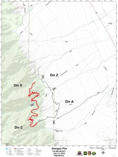
Georges Fire
This fire is off Hogack and Whitney Portal Road in Alabama Hills, Inyo County. It’s now 2,833 acres and 70 percent contained. It was caused by lightning.
Horse Creek Fire
This fire is off Mineral King Road in the Ash Mountain area of Tulare County. It’s 34 acres and 90 percent contained. It was caused by lightning.
Natchez Fire
This fire falls under the jurisdiction of the Oregon Department of Forestry Fire, but is listed on the CAL FIRE map.
Pasqual Fire
Per CAL FIRE: “Off of San Pasqual Valley Rd, west of Ramona (San Diego County) is now 365 acres and 55% contained.” All evacuations lifted as of 7 p.m. July 28.
Sobrante Fire
According to CAL FIRE: “Firefighters are battling a 10 acre fire off El Sobrante Road at McAllister Street, Lake Matthews (Riverside County).”
Ranch Fire (Mendocino Complex)
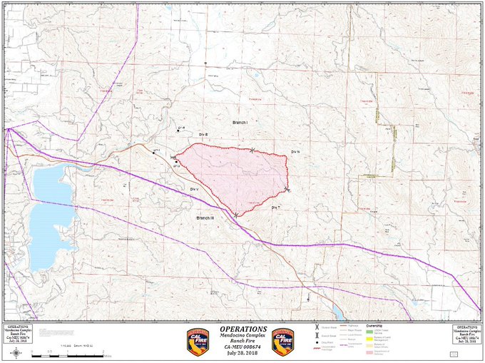
This fire is off Highway 20 near milepost mark 39-SE of Potter Valley and northwest of Blue Lakes, eight miles northeast of Ukiah in Mendocino County. It was 30 acres earlier on Friday but has grown to 5,000 acres and 5 percent containment. One firefighter has been injured.
See evacuation orders and advisories at the Mendocino County Sheriff’s Facebook page.
Ribbon Fire
This fire is at Highway 74 and Ribbonwood Drive, near Pinyon in Riverside County. It’s now 200 acres and 70 percent contained. Some of the Cranston fire maps above also include the Ribbon fire. As of the morning of July 27, all evacuation warnings have been lifted.
River Fire (Mendocino Complex)
Per CAL FIRE: “Off Old River Road, near Mile Marker Post 7.9, Hopland (Mendocino County) is now 9,000 acres and 5% contained.”
Rock Fire
According to CAL FIRE: “Off Sandia Creek and Rock Mountain Drive, Fallbrook (San Diego County) is now 225 acres and 10% contained. Evacuations and road closures in place.”
As of July 28 at 7 pm, approximately 100 homes along Sandia Creek were being evacuated
Roxie Fire
This fire is west of Willard Creek Road, 10 miles west of Susanville in Lassen County. It’s 167 acres and 90 percent contained.
Steele Fire
According to CAL FIRE: “Off Arroyo Grande Drive and Steele Canyon Road, Capell (Napa County) is now 150 acres and 10%.”
As of 10 pm July 28: evacuations ordered in Pleasure Cove Resort, Community of Berryessa Highlands. An evacuation center is at Crosswalk Community Church, 2590 – 1st Street, Napa.
Valley Fire
The Valley fire remains at 1,348 acres and 29 percent contained. It’s at the Valley of the Falls Dr. and Service Road 1S08. According to Inciweb, minimal to no growth is expected and very little fire spread is expected. However, hot and dry conditions have helped the fire stay active.
Whaleback Fire
This fire is 8,000 acres and 5 percent contained. According to Inciweb at 9:35 pm July 28: “This fire is burning south of the community of Spalding, on the western edge of Eagle Lake, about 20 miles northwest of Susanville, Calif. There are mandatory evacuations in place for Spalding Tract and recreation sites around the south end of the lake… Mandatory evacuations in place for the community of Spalding, the Gallatin Marina, Ronald McDonald House and the Merrill, Christie, Eagle and Aspen campgrounds.”
