Inciweb California Fire Map Near Me
Containment levels on fires in California are improving, but that doesn’t mean the state is out of the woods completely. Fires are still an issue in California on on August 21. Read on to learn all the details about the current fires in California, with a roundup of maps of the larger fires around the state, their containment levels, evacuation details, and where the fires are located. News is constantly changing, so call your local officials if you are concerned about evacuations near you.
Interactive Maps of California Fires
This map below is an interactive map of the more significant fires in California, consistently updated and provided by CAL FIRE and Google. Fires in red are active and fires in black are contained. Read the next section for details about the fires listed on the map. You may need to zoom into this map to see California up close.
The California Governor’s office has another active fire map for comparison, which is embedded below. This map periodically is made available only to those with a login, so if it’s not available when you’re reading this story, it might be released to the public again later. This map includes a major incident summary for the day.

Below is another active fire map from Google’s Crisis Map. Zoom in to see areas of interest. This map also includes fires in other states.
Next are more specific details on the fires for August 21. The details are extensive, so if you are looking for a specific fire, search for the name so you can find it faster, or just scroll down and look at the fires, listed in alphabetical order.
List of Active Fires in California as of August 21
Here are the active fires and updates about them, per CAL FIRE. Most of these are in alphabetical order, but newer fires not yet listed on the CAL FIRE map may be included in a separate section at the end.
Alhambra Fire
CAL FIRE is assisting @ContraCostaFire with a fire off Highway 4 and Alhambra Ave, Martinez (Contra Costa County). #AlhambraFire ***This is not a CAL FIRE incident. Click the link for more information: t.co/nATbmwpwf8
The Alhambra Fire is listed on CAL FIRE’s map although it’s not technically a CAL FIRE incident. On August 17, Contra Costa County Fire’s public information office noted that forward progress of the fire had been stopped at 30 acres. No further updates have been posted since.
Call Fire
According to the CAL FIRE map: “CAL FIRE is assisting the USFS Sequoia National Forest with a fire off Cow Flat Road and Highway 178, west of Lake Isabella (Kern County). #CallFire ***This is not a CAL FIRE incident.”
#CallFire
370 Acres
Contained: 50%
The fire is reported to be 370 acres and 50 percent contained as of August 20.
Carr Fire
The Carr Fire is off Highway 299 and Carr Powerhouse Road in Whiskeytown (Shasta County.) You can see an interactive map above. The fire is 229,651 acres and 90 percent contained, according to CAL FIRE.
There are 1,079 residences that were destroyed, 22 commercial structures, and 503 outbuildings. Sadly, there were also three firefighter fatalities. The fire was caused by a vehicle’s mechanical failure.
You can get the most latest updates on evacuations from the Shasta County Sheriff’s Office here. But as of August 21, there are no evacuations listed. No structures are currently threatened.
Assistance and evacuation centers as of August 21: The Disaster Recovery Center at the old Kmart building at 2685 Hilltop Dr. in Redding, from 9 a.m. to 7 p.m. daily.
For details on public land closures, please see the following:
Animal evacuation center:
- Small Animal – Haven Humane 9417 East Side Drive Redding, Ca.
Per CAL FIRE: “For information on evacuation notifications visit http://www.shascom911.com. Click for the most up to date evacuation orders and advisories at the Shasta County Sheriff’s page.”
Cloverdale Fire
This fire is off San Pasqual Valley Road near Escondido in San Diego County. It was 100 acres and 65 percent contained as of August 15. It’s still listed on CAL FIRE’s map, but more recent updates aren’t available.
Donnell Fire
InciwebDonnell Fire Map August 20
This fire is in the Stanislaus National Forest and is 31,743 acres with 51 percent containment, as of August 21.
A total of 54 structures were destroyed and there were four injuries. The fire started at the inlet of the Donnell Reservoir, and 220 structures are still threatened as of August 21, according to Inciweb.
Mandatory evacuations are still in effect in the following areas as of August 21: “Still in effect along Highway 108 from Eagle Meadow Road to Kennedy Meadows (all residences and campgrounds, except Baker and Deadman) as well as all along Eagle Meadow Road (5N01) and the Clark Fork Road area. No new mandatory evacuations have been ordered.”
An advisory evacuation is still in effect for the Mill Creek area.
According to Inciweb on August 20: “High pressure will weaken today as an area of low pressure moves into the Pacific Northwest. This will allow for gusty southwest winds to develop in the afternoon with gust between 25-30 mph. The strongest gusts will occur in the aligned southwest to northeast valleys along with the exposed ridges.”
The fire information line is 209-536-5388.
Ferguson Fire (Yosemite Fire)
This fire, off Highway 140 and Hite Cove, near El Portal in Mariposa County, is no longer listed on CAL FIRE’s map. According to Inciweb on August 20, it was 96,901 acres and 100 percent contained.
The fire began on July 13 in the Merced River canyon near El Portal around 10:35 p.m., Merced Sun Star reported, and at the time was less than 200 acres. It grew substantially from there. The cause of the fire in the Savage Trading Post area is currently unknown.
Front Fire
According to the CAL FIRE map: “CAL FIRE is assisting the USFS Los Padres National Forest with a fire off Highway 166 and Sierra Madre Road (Santa Barbara County). #FrontFire ***This is not a CAL FIRE incident.”
KSBY provided more details. Progress is being made on the Santa Barbara County fire and officials are working on mopping up hot spots. Highway 166 was reopened.
According to Inciweb, the fire is 900 acres and 29 percent contained as of August 21. The cause is under investigation. It’s at Rockfront Ranch, 30 miles east of Santa Maria on Highway 166, at 35.117 latitude, -120.101 longitude.
Garner Complex Fire
Although still listed on CAL FIRE’s map, it is no longer considered an active fire and Inciweb is no longer updating details about it. It’s 8,886 acres and 85 percent contained as of August 9.
Georges Fire
This fire has been inactive for several weeks and is 95 percent contained, per Inciweb on August 14. It is still listed on CAL FIRE’s map.
Gorge Fire
According to the CAL FIRE map: “#GorgeFire [update] off Highway 36 west and Beegum Gorge road, Platina area (Shasta County) is now 155 acres and 90% contained. Forward spread stopped. Highway 36 remains closed. ”
However, an August 21 update by Cal Fire indicated that Highway 36 is actually now open through the fire area to all traffic.
Hirz Fire
InciwebHirz Fire Map
This fire is not a CAL FIRE but it is listed on CAL FIRE’s map. It’s grown from 450 acres on the 10th to 17,467 acres on August 21 and 17 percent contained.
The fire is located north of Moore Creek Campground. It’s 11 miles east of Interstate 5 on Gillman Road near Lakehead, California. It’s 18 miles northeast of Redding, California.
The cause is under investigation. This listing is actually three fires near Hirz Bay and Moore Creek Campground off Gilman Road on the McCloud Arm of Shasta Lake. Be cautious of fire traffic on Gilman Road.
Monday 8/20 #HirzFire east of Lakehead, CA. Map always shows most recent satellite hotspots. See “Legend” and “Map tips” links to get the most benefit from the map. Open interactive map: t.co/9f7czJnQbg #GeoSpatial
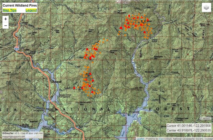
Inciweb notes that most of the fire’s activity is around Nawtawaket Mountain, slowly progressing along the McCloud River.
Inciweb noted on August 21 about evacuations and closures:
- “Residents of Old Mill Road, Bonnie Vista Lane, Top of the Hill Trail, Hirz Mountain Road, the north side of Gilman Road, and the Bollibokka Fishing Club are still evacuated. Because the fire is slow moving, the evacuation will remain in place until authorities determine there is no longer a threat to structures in the area.
- “Gilman Road continues to have a soft closure in place for the area between Old Mill Road and the McCloud River Bridge. Residents who live south of Gilman Road within the soft closure area, who have not been notified to evacuate, will be allowed to continue accessing their property. Please use extreme caution when driving Gilman Road and be alert for fire suppression vehicles and crews working along the road.”
County residents can sign up to receive emergency updates and critical information through www.shascom911.com using the Code Red program.
A public meeting will take place August 21 at 6 p.m. at McCloud High School at 133 Campus Way in McCloud, California.
Holy Fire
The Holy Fire formed on August 6 in the afternoon and quickly grew. You can see an interactive map of the Holy Fire here, but that map may no longer be updated.
The Holy Fire is in Orange County, off Holy Jim Canyon Road, west of the North Main Divide. As of August 18 (the most recent update), the fire is 22,885 acres according to Inciweb, and 91 percent contained.
Another interactive map is below:
The cause is under investigation, but authorities have arrested Forrest Gordon Clark on suspicion of felony arson. Read more about Clark in Heavy’s story here.
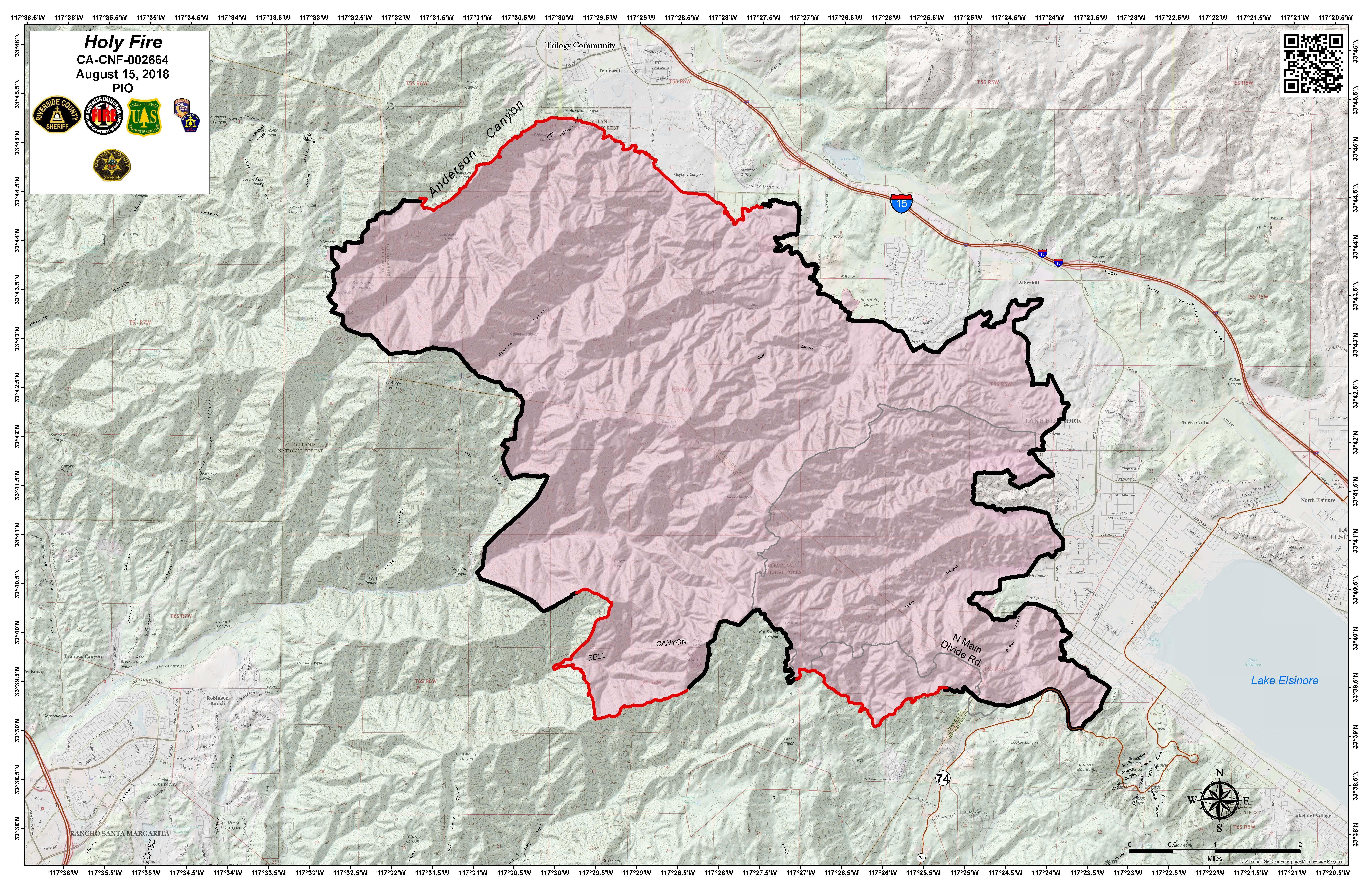
InciwebHoly Fire Map August 15
A public information hotline has been set up at 714-628-7085 for the Holy Jim area.
All evacuations for this fire have been lifted, Inciweb noted.
Lions Fire
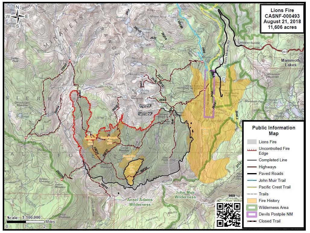
InciwebLions Fire Map August 21
This fire is listed on the CAL FIRE map. It’s 11,606 acres and 75 percent contained as of August 21. It’s located seven miles southwest of Mammoth Lakes. It was caused by lightning. Most of the fire is on the Sierra National Forest, but about 1,600 acres are on the Inyo National Forest. The northwest portion of the fire heated up on August 19 due to gusty winds and low humidity.
Regarding closures, Inciweb noted on August 20: “All services on the Sierra and Inyo National Forests and Devils Postpile National Monument remain open. The Sierra and Inyo National Forests have implemented fire restrictions on all National Forest lands until further notice. The following restrictions are in effect: No campfires, briquette barbeques, or stove fires are allowed outside designated developed recreation sites, and specifically posted campsites or areas. No fireworks, including “safe and sane” fireworks. No smoking, except within an enclosed vehicle or building, developed recreation site, or while stopped in an area at least three feet in diameter that is barren or cleared of all flammable material.”
Mill Creek 1 Fire
#millcreek1fire MODIS live heat map. While this is not an accurate depiction of the current fire perimeter, it does help to indicate the most active perimeters. To download the latest MODIS Google Earth KML file go here: t.co/SPySKmWJfL

This fire was first detected on August 16. It’s 1,500 acres and 5 percent contained, according to Inciweb. The fire is at Mill Creek North of Hoopa, California, on the Hoop Indian Reservation. It’s located at Latitude: 41ᵒ 8’ 24” Longitude: 123ᵒ 39’ 36”.
The cause of the fire is arson. A $10,000 reward has been offered for information regarding the fire. You can also call anonymously at 1-800-468-4402.
According to Inciweb: “Our objective is to keep the fire East of Highway 96, west of the Reservation boundary, north of Mill Creek and south of Deerhorn Creek. Resources are being ordered to assist with the suppression of the fire. Currently we are in a National Preparedness Level 5, mobilization of fire resources is heavily committed to numerous large fires throughout the country…”
The following closures are in place: “California State Highway 96 is closed from Bull Creek to Mill Creek due to fire behavior. Traffic is being redirected through Dowd Road. This is for the safety of the public as well as for crews and aerial resources working on the fire. As soon as it is safe for public travel the highway will be reopened.”
A public meeting on this fire will take place August 21 at 6 p.m. at 11900 CA-96, Hoopa, California, at the Hoopa Neighborhood Facility.
The fire information line is 530-618-2844. Updates will also be posted on the Hoopa Valley Facebook Page.
Natchez Fire

InciwebNatchez Fire Map August 20
This Oregon fire falls under the jurisdiction of the Oregon Department of Forestry Fire, but is also listed on the CAL FIRE map. It’s grown to total 20.275 acres acres on August 20, and 70 percent contained. It was caused by lightning. It’s located 15 miles southeast of Cave Junction, Oregon, located on the Oregon/California border between Happy Camp, California and Cave Junction, Oregon. Some active surface spread is still expected.
On August 20, Inciweb still reported the following regarding evacuation orders and fire closures:
- “The community of Sunstar remains in a Level 1 evacuation Ready status. Del Norte County, CA, including the community of Sunstar, has adopted the Oregon three level evacuation process.
- “Siskiyou County Sheriff’s Office has expanded an Evacuation Order for the area south of the Natchez Fire. The expanded law enforcement order can be obtained directly from the Sheriff’s Office Facebook page at https://www.facebook.com/SiskiyouCountySheriff/.
- “The emergency closure area surrounding the Natchez Fire was expanded on August 17th. The expansion was necessary due to fire growth on the southern end. Going into or being on National Forest lands, roads, or trails within the closure area is prohibited. Forest Road No. 48, known as Grayback Road, remains open to public use.
- “The new boundary for the emergency closure area begins at the intersection of Forest Road 48 (Grayback Road) and the common boundary between the Klamath National Forest boundary and the Rogue River-Siskiyou National Forest, then continues southeasterly along the western edge of Grayback Road to its intersection with Highway 96, then continues southwest along the northern edge of Highway 96 to its intersection with Forest Road No. 17N16 (Benjamin Creek Road), then continues on Forest Road No. 16N10 (Oak Flat Road). From that point the emergency closure boundary follows a northwesterly direction up to the boundary between the Klamath National Forest and the Rogue River-Siskiyou National Forest. A full description and map of the closure area is available on Inciweb at: https://inciweb.nwcg.gov/incident/closures/5948/.
- “Closure Order for Rogue River – Siskiyou National Forest within the vicinity of the Natchez Fire. Going into or being upon National Forest System lands within the Natchez Fire Closure Area is prohibited. Information and maps about closures for River-Siskiyou National Forest can be found at: https://inciweb.nwcg.gov/incident/closures/5948/.”
A community fire meeting is scheduled for Tuesday, August 21 at 6 p.m. at the Grange in Happy Camp, CA.
Ranch Fire (Mendocino Complex Fire)
Tuesday 8/21 #RanchFire CA. Map shows perimeter based on last night infrared flight + analysis by fire staff. Also shows latest satellite hotspots. See “Legend” and “Map tips” links to get the most benefit from the map. Open online map: t.co/JELgmBD33X #GeoSpatial

This fire was the largest in California’s history. It’s off Highway 20 near Potter Valley, northeast of Ukiah in Mendocino/Lake/Colusa Counties. Containment efforts are finally working, as firefighters make great success in getting this fire under control.
It’s now 355,612 acres and 67 percent contained as of August 21. So far, 157 residences have been destroyed. (The total for the entire Mendocino Complex fire is 404,532 acres and 74 percent containment.) One firefighter has died in connection to the fires.
On August 21, CAL FIRE reported the following: “Overnight, the the Ranch Fire continued to burn through portions of grass, timber and brush in the steep terrain in northern portions of the fire area. Fire activity is expected to increase in the later part of the afternoon as smoke clears. Additionally, fire activity is expected to decrease in the later evenings due to increased humidity and lower temperatures. Over 9 miles of firing occurred last night on the northern portion of the Ranch Fire. Firing operations will continue as weather conditions permit. The southern portion of the fire remains in patrol status as crews continue with suppression repair and mop up. The River Fire had no movement. Suppression repair along with patrol will continue on the River Fire.”
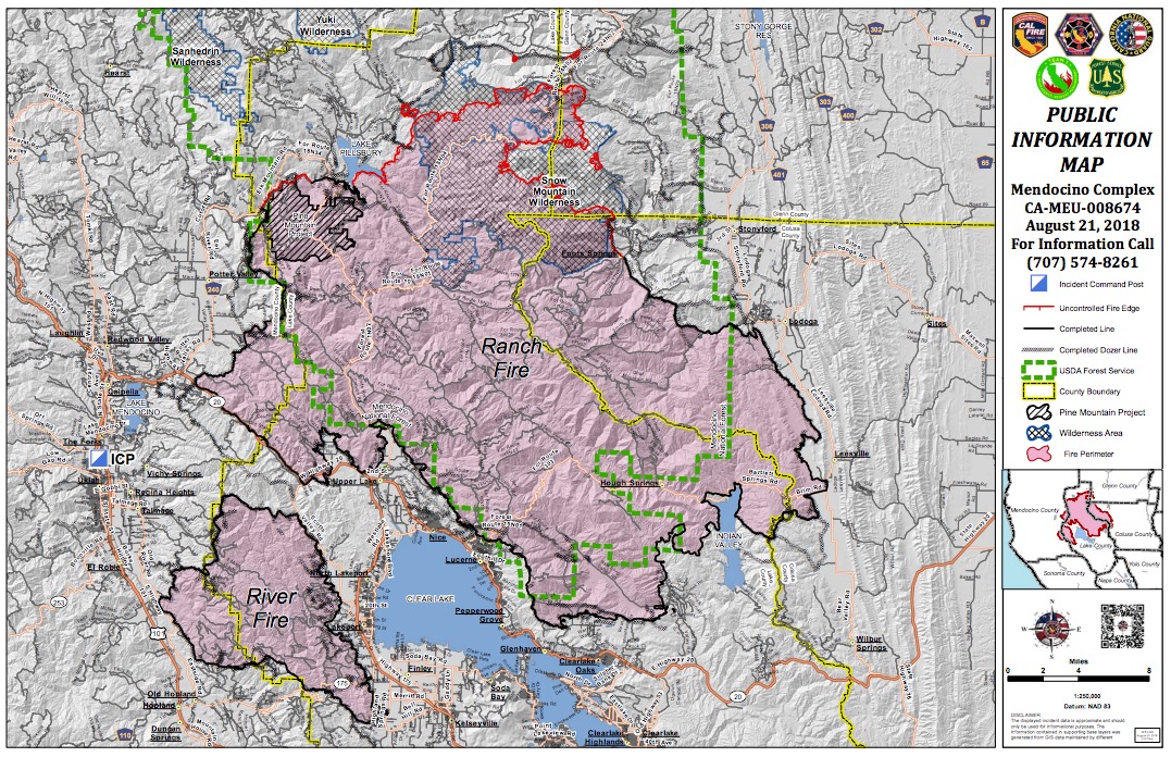
InciwebRanch Fire Map
See the latest evacuation orders and advisories at the Mendocino County Sheriff’s Facebook page , Colusa County Facebook page, and the Lake County Sheriff’s Facebook page. The following mandatory evacuations are in place for the Ranch and River fires as of August 21 at 7 a.m.
Mendocino County:
- South and East of Eel River Road, west of the Mendocino-Lake county line, North of the 16000 block of Mid Mountain Road.
Lake County:
- East of the Lake-Mendocino County Line, south of the Lake-Mendocino-Glenn County Line, west of the Lake-Colusa County Line, north of the fire perimeter and the Mendocino National Forest boundary.
Colusa County:
- Areas west of LodogaStonyford Road including Fouts Springs Road (Forest Road M10), Goat Mountain Road, Cooks Spring Road, Walker Ridge Road and Brim Road.
Glenn County:
- North of the Glenn-Colusa County line, east of the GlennLake County line, south of County Road 308 and Forest Route 24N02, and west of County Road 306.
The following evacuation advisories/warnings are in place:
Mendocino County
- North of Pine Ave, South of the 16000 block of Mid Mountain Road, west of the Mendocino National Forest boundary, and east of eastside Potter Valley/Eel River Roads.
- The Bureau of Land Management closure of the Cow Mountain Recreation Area remains in effect.
Colusa County
- All areas east of the Mendocino National Forest boundary and west of the East Park reservoir between the Glenn County line and Lodoga.
- Areas South of Goat Mountain Road extending to Sullivan Ridge east of the Colusa-Lake County line and West of the Mendocino National Forest boundary
Animal evacuation centers:
- Redwood Riders Arena, 8300 East Road, Redwood Valley is accepting horses
- Animal Care, 298 Plant Road, Ukiah is accepting small animals
For updated details, call 707-574-8261 in Mendocino County.
River Fire (Mendocino Complex)
Per CAL FIRE, the River Fire is now 48,920 acres and 100 percent contained. For details about evacuations etc., see the Ranch Fire update above.
Stone Fire
InciwebStone Fire Map August 20
This fire is listed on CAL FIRE’s map without specific details, but you can find details on Inciweb here. It’s 23,221 acres and 12 percent contained as of August 21, located at 41.395 latitude, -121.057 longitude. It’s 10 miles west-southwest of Canby, California and 15 miles northwest of Adin, California.
A public meeting about the fire will be August 21 at 4 p.m. at the Cal Pines Fire Station at 345 County Road 230 in Alturas, California.
The Stone Fire was started by a lightning storm on August 15. It’s west of Yellowjacket Spring and south of County Road 84, KOBI5 reported.
Inciweb noted the following about evacuation orders on August 21:
- “Evacuation orders have been lifted for County Road 214 and County Road 215.
- “Mandatory evacuations and road closures are still in effect for County Road 84 and County Road 85.
- “Motorists can expect piloted traffic and temporary closures on Highway 299 due to fire activity.
- “For the most updated information, contact Caltrans at 1-800-GAS-ROAD.”
Taylor Creek Fire
InciwebTaylor Creek Klondike Fire Maps August 20
This Oregon fire, which was also listed on CAL FIRE’s map at one point, has been split into two “zones” as of August 19: the Taylor Creek and Klondike East fires and the Klondike West Fire. The cause is lightning. Increased fire activity is still expected. Dry fuels and hot, dry weather have fueled both this fire’s and Taylor Creek’s growth. Inaccessible and steep terrain have made suppression a challenge. Both fires are actively burning in the scar of the 2002 Biscuit Fire, according to Inciweb, which has helped the fires spread west.
As of August 20, the Taylor Creek Fire is 52,588 acres and 79 percent contained. The Klondike Fire is 72,074 acres and 28 percent contained (up from 15 percent containment yesterday.)
You can see an interactive map of evacuation levels here. Just enter your address to see if you are under an evacuation advisory.
Inciweb noted on August 20: “Extremely dry fuels and hot, dry weather have fueled the continued growth of both fires. Steep, rugged, inaccessible terrain combined with limited resources due to intense wildfire activity across the western United States has made suppression efforts a challenge. In addition, smoky conditions have limited the use of aircraft to suppress and monitor both fires.”
A public meeting about the fires is August 20 at 6 p.m. in the Agness Community Library in Agness. There will be another public meeting on August 21 in Gold Beach at the Curry County Fairgrounds in the Curry Showcase Building on 29392 Ellensburg Avenue.
The Klondike Fire and the Taylor Creek Fire are being managed by the Pacific Northwest Team 2.
Valley Fire
The Valley fire is 1,350 acres and 82 percent contained as of August 20. It’s at the Valley of the Falls Dr. and Service Road 1S08. According to Inciweb, minimal to no growth is expected and very little fire spread is expected. However, hot and dry conditions have helped the fire stay active. Inciweb isn’t actively updating this every day.
The Valley Fire closure area was reduced on August 15. See more here.