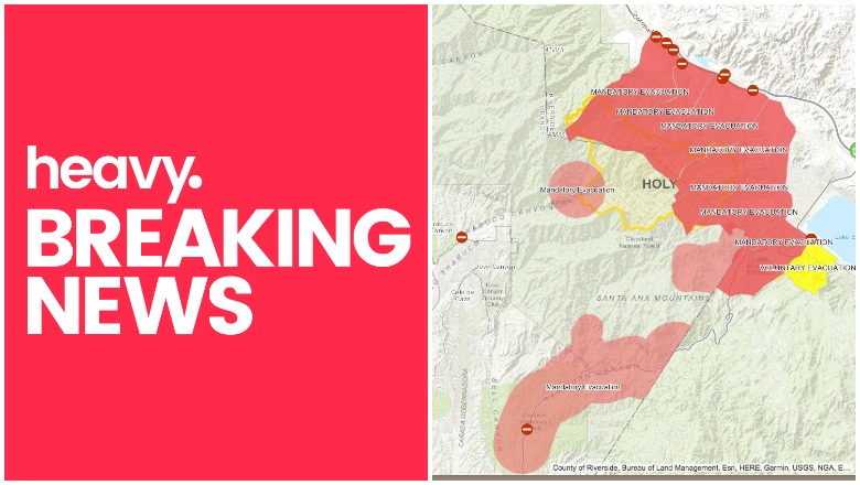
Orange County Sheriff\'s Department Emergency Management Division Holy Fire Map
The Holy Fire in California just started Monday afternoon and exploded to 4,000 acres in size on August 7. Now, as of Friday, August 10, growth has exploded once again and the fire is now 18,137 acres in size. Evacuations have been ordered for this fire and officials are working to keep it under control, but it keeps growing. Read on to see maps on the fire’s location and details about evacuations.
Where Is the Holy Fire? Interactive Maps to Help You Track the Fire’s Location on August 10
This interactive map of the Holy Fire, which you can view below or here, can help you stay updated on the fire’s location. This map also lists evacuation locations.
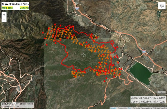
The fire is in Orange County, off Holy Jim Canyon Road, west of the North Main Divide. The fire started Monday afternoon and quickly grew to more than 100 acres, The OCR reported, and by Wednesday it was at 4,129 acres with 5 percent containment. Now the containment level is the same, but the fire has more than doubled. On Thursday night it grew to 10,236 acres in size. As of Friday morning, according to CNN, it’s now 18,137 acres in size and still just 5 percent contained.

#HolyFire morning update: 18,137 acres and 5% contained. For those wondering about containment, the hand/containment line grows as the fire grows. We continue to actively engage, but cannot get ahead of the fire.

It’s good to view several interactive maps, just in case one map isn’t kept updated. This map, for example, is from CAL FIRE. You may need to zoom in to see the Holy Fire:
The California Governor’s office has another active fire map. You can zoom in to the Holy Fire. Sometimes this map requires a login, however. If it doesn’t work, just move on to the next interactive map and this one might work later.
Below is another active fire map from Google’s Crisis Map. Zoom in to see the Holy Fire details and click on the Holy Fire icon itself to see details about the fire.
You can also click on the interactive map in the tweet below to see helpful details:
8/10 Friday#HolyFire. Latest perimeter from infrared flight late yesterday with help from @pjdohertygis. Map also always shows latest satellite hotspots. See “Legend” and “Map tips” links in upper left corner. Open online map: t.co/bUkdfmYsek #GeoSpatial
The fire is in Orange County, off Holy Jim Canyon Road, west of the North Main Divide. The cause is under investigation, but authorities have arrested Forrest Gordon Clark on suspicion of felony arson. Read more about Clark in Heavy’s story here.
Next up is a 3D map showing the approximate location of the fire.
Firefighters battle #HolyFire as it approaches structures. The fire has burned over 18,000 acres northwest of Lake Elsinore, California. t.co/cRs8TXjMBv

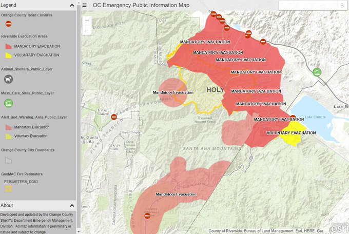
And another map. The one in the tweet below and at this link is an interactive map created by the Orange County Sheriff’s Department Emergency Management Division. It includes evacuation details, animal shelter details, and more.
If you are using my map for #HolyFire and live in the area or have loved ones in the area – please see this more informative map w/ evac zones, road shelters, and shelters
And another map:
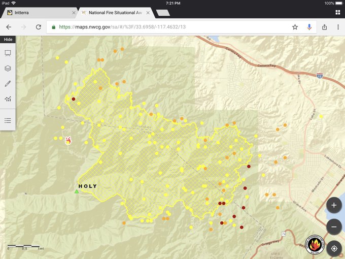
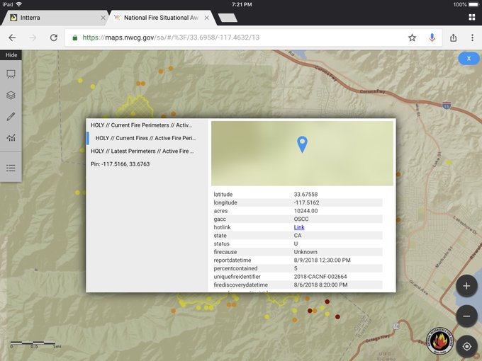
1️⃣ #HolyFire perimeter and #MODIS hot spots (as of 1925 Pacific on 09 August 2018).
2️⃣ Fire information – Over 10,000 acres and 5% contained.
#EnterpriseGeospatialPortal (powered by #Intterra)
And another interactive map is below:
The U.S. Forest Service explained the containment issues in a tweet. “For those wondering about containment, the hand/containment line grows as the fire grows. We continue to actively engage, but cannot get ahead of the fire.”
Holy Fire Evacuation & Shelter Details
*IMPORTANT* #HolyFire Evacuation Information from Orange County Sheriff – bookmark this map! Looks like they have Orange County and Riverside County covered. t.co/enqj9WyNGO
More than 21,000 people have been evacuated, including about 7,500 homes as of Friday, August 10, KTLA 5 reported. Twelve structures burned when the fire first started on Monday, but so far no additional structures have been lost. A public information hotline has been set up at 714-628-7085 for the Holy Jim area.
No major injuries have been reported from the fire. The fire continues to move near homes in Lake Elsinore.
Mandatory evacuations were ordered in McVicker Canyon, Rice Canyon, Horsethief Canyon, El Cariso, Rancho Capistrano, Blue Jay, Indian Canyon, Glen Eden, Sycamore Creek and Mayhew Canyon, ABC 7 reported. In addition, all homes on the mountainside of Lake Street and southwest of Grand Avenue to Ortega Highway are also under a mandatory evacuation as of the morning of August 10.
Voluntary evacuations were issued for:
- Highway 74 (Ortega Highway) west from Lookout Restaurant to Nichols Institute and all connecting roads in the communities of Rancho Capistrano, El Cariso Village and Blue Jay. Residents are advised to exit west to Orange County to avoid fire equipment coming up on the Elsinore side.
- Highway 74 eastbound is also closed.
- According to Cleveland National Forest, a new voluntary evacuation notice was issued for the Machado community on August 9.
Here are the evacuation centers, according to ABC 7:
- A care and reception center is at Temescal Canyon High School at 28755 El Toro Road in Lake Elsinore.
- An evacuation center is at San Juan Hills High School at 29211 Stallion Ridge in San Juan Capistrano.
- Animal Friends of the Valley is at capacity, but Riverside County Animal Services employees are accepting animals at Temescal Canyon High School and at the San Jacinto shelter. CAll 951-358-7387 for details.
Tilson Shumate and his wife told ABC 7 that they barely made it out alive. “Fire travels faster than you think. It’s an incredible sensation to be in this and to be faced with life and death. We think we’re ready to die, but are we? I don’t know, man. I don’t want to go like this, Lord, get us out of here.”
The fire is dangerously close to homes in the Lake Elsinore-Corona area.
An interactive map at this link was created by the Orange County Sheriff’s Department Emergency Management Division. It includes evacuation details, animal shelter details, and more.
Evacuation details are constantly changing, so call your local officials or police if you’re concerned about your area. A public information hotline has been set up at 714-628-7085 for the Holy Jim area. The @ClevelandNF account on Twitter is also a good source to follow.
The fire is expected to continue to spread south, east, and north, but only limited spread west, Inciweb reported.