CAL FIRE California Fire Map of Fires Near Me
Here are the latest updates on all the fires in California as of September 19, with a roundup of maps of the larger fires around the state, their containment levels, evacuation details, and where the fires are located. News is constantly changing, so call your local officials if you are concerned about evacuations near you.
NOTE: If you are looking for an updated story for October 7, see Heavy’s new story about California fires here.
Interactive Maps of California Fires
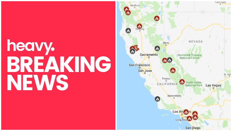
This map below is an interactive map of the more significant fires in California, consistently updated and provided by CAL FIRE and Google. Fires in red are active and fires in black are contained. Read the next section for details about the fires listed on the map. You may need to zoom into this map to see California up close.
The California Governor’s office has another active fire map for comparison, which is embedded below. This map periodically is made available only to those with a login, so if it’s not available when you’re reading this story, it might be released to the public again later. This map includes a major incident summary for the day.

Below is another active fire map from Google’s Crisis Map. Zoom in to see areas of interest. This map also includes fires in other states.
Next are more specific details on the fires for September 18. The details are extensive, so if you are looking for a specific fire, search for the name so you can find it faster, or just scroll down and look at the fires, listed in alphabetical order.
List of Active Fires in California as of September 19
Here are the active fires and updates about them, per CAL FIRE. Most of these are in alphabetical order, but newer fires not yet listed on the CAL FIRE map may be included in a separate section at the end.
Delta Fire *
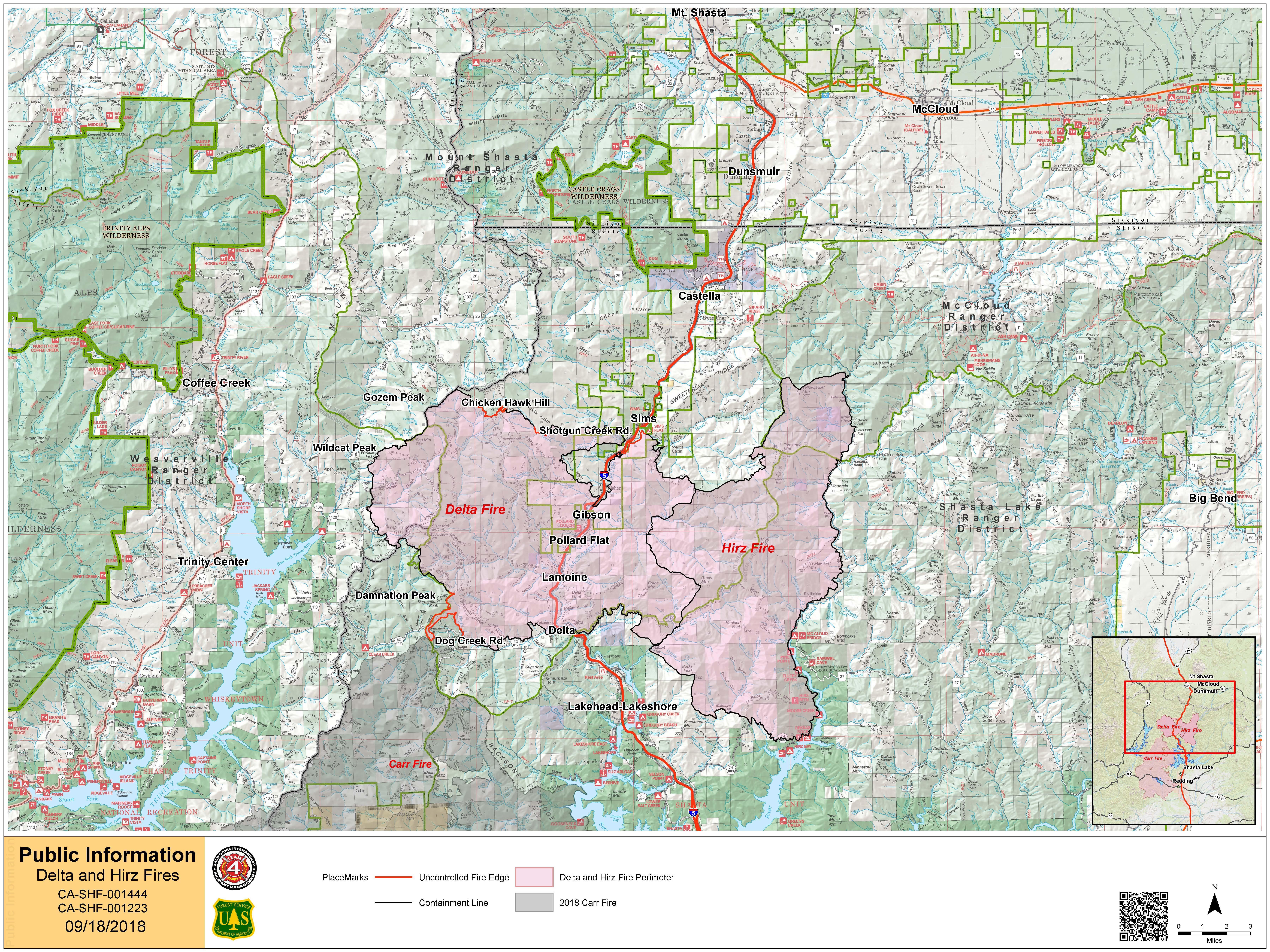
InciwebDelta Fire Map
The Delta Fire is 60,277 acres and 87 percent contained, after first being reported on September 5 near the Vollmers exit on I-5 north of Lakehead, California. It was initially three fires that merged into one fire. Seventeen structures were destroyed in the fire.
The fire was caused by human activity.
Mandatory evacuations issued by the Shasta County Sheriff’s Office were lifted at 12 p.m. on September 16, so there are no current evacuations or advisories. But the public should stay vigilant of fire conditions.
According to Inciweb, the following forest closures are in place as of Sept. 18:
“Shasta-Trinity National Forest officials have combined the previously issued Hirz Fire Closure Order and Delta Fire Closure Order into one new closure order that includes both fire areas. The new Hirz Delta Fire Closure Order, 14-18-19, was issued on September 15, 2018. All previously closed forest roads, trails, and facilities remain closed with the following exceptions:
- The Pacific Crest Trail between Ash Camp and Gumboot is now open with no restrictions.
- All campgrounds east of Interstate 5 along Gilman Road are now open.
- Hirz Bay Boat Launch has been reopened. The McCloud Arm of Shasta Lake remains open for water traffic.
- Access to Girard Ridge Lookout has been restored. For more information regarding facility usage and reservations, please call the McCloud Ranger Station at (530) 964-2184, Monday through Friday 8 a.m. to 4:30 p.m.
“Forest areas impacted by the Hirz and Delta fires pose a significant health and safety risk. Significant suppression and repair work is being done throughout these closed areas. These areas will remain closed until further notice. View the new Closure Order below.”
The Delta Fire information line is 530-498-0953. Leave a message if someone doesn’t answer.
Donnell Fire *
This fire is in the Stanislaus National Forest and is 36,349 acres with 90 percent containment, as of September 13. A total of 54 structures were destroyed and there were nine injuries. The fire started at the inlet of the Donnell Reservoir. The cause is not known, and Inciweb is no longer updating details about this fire, as it is now well contained. The fire information line is 209-536-5388.
Essex Fire *
CAL FIRE is helping Modoc National Forest with this fire, which is located east of Essex Reservoir and northeast of Canby in Modoc County. The fire is still listed as active on CAL FIRE’s map as of September 19, but CAL FIRE hasn’t released any updates on the fire since September 4.
Fork Fire *
“CAL FIRE is assisting the Angeles National Forest with a wildfire off East Fork Rd & San Gabriel Canyon Rd, Azusa (Los Angeles County),” according to CAL FIRE’s map listing. According to Inciweb, the fire is 166 acres and 98 percent contained. The cause is under investigation. It’s located at San Gabriel Canyon, Highway 39 near the East Fork junction.
Garner Complex Fire *
Although still listed on CAL FIRE’s map, it is no longer considered an active fire and Inciweb is no longer updating details about it. It’s 8,886 acres and 85 percent contained as of August 9.
Georges Fire *
This fire has been inactive for several weeks and is 95 percent contained, per Inciweb on August 14. It is still listed on CAL FIRE’s map.
Holy Fire *
The Holy Fire formed on August 6 in the afternoon and quickly grew. The Holy Fire was in Orange County, off Holy Jim Canyon Road, west of the North Main Divide. As of September 13, the fire is 23,136 acres according to Inciweb and 93 percent contained.
The cause is under investigation, but authorities have arrested Forrest Gordon Clark on suspicion of felony arson. Read more about Clark in Heavy’s story here.
A public information hotline has been set up at 714-628-7085 for the Holy Jim area. The fire is no longer considered active and Inciweb is no longer updating details about the fire.
Lions Fire *
This fire is listed on the CAL FIRE map. It’s 13,347 acres and 85 percent contained as of September 10. It’s located seven miles southwest of Mammoth Lakes. It was caused by lightning. Most of the fire is on the Sierra National Forest, but about 1,600 acres are on the Inyo National Forest. The fire is now in monitoring status and is no longer considered active.
Natchez Fire *
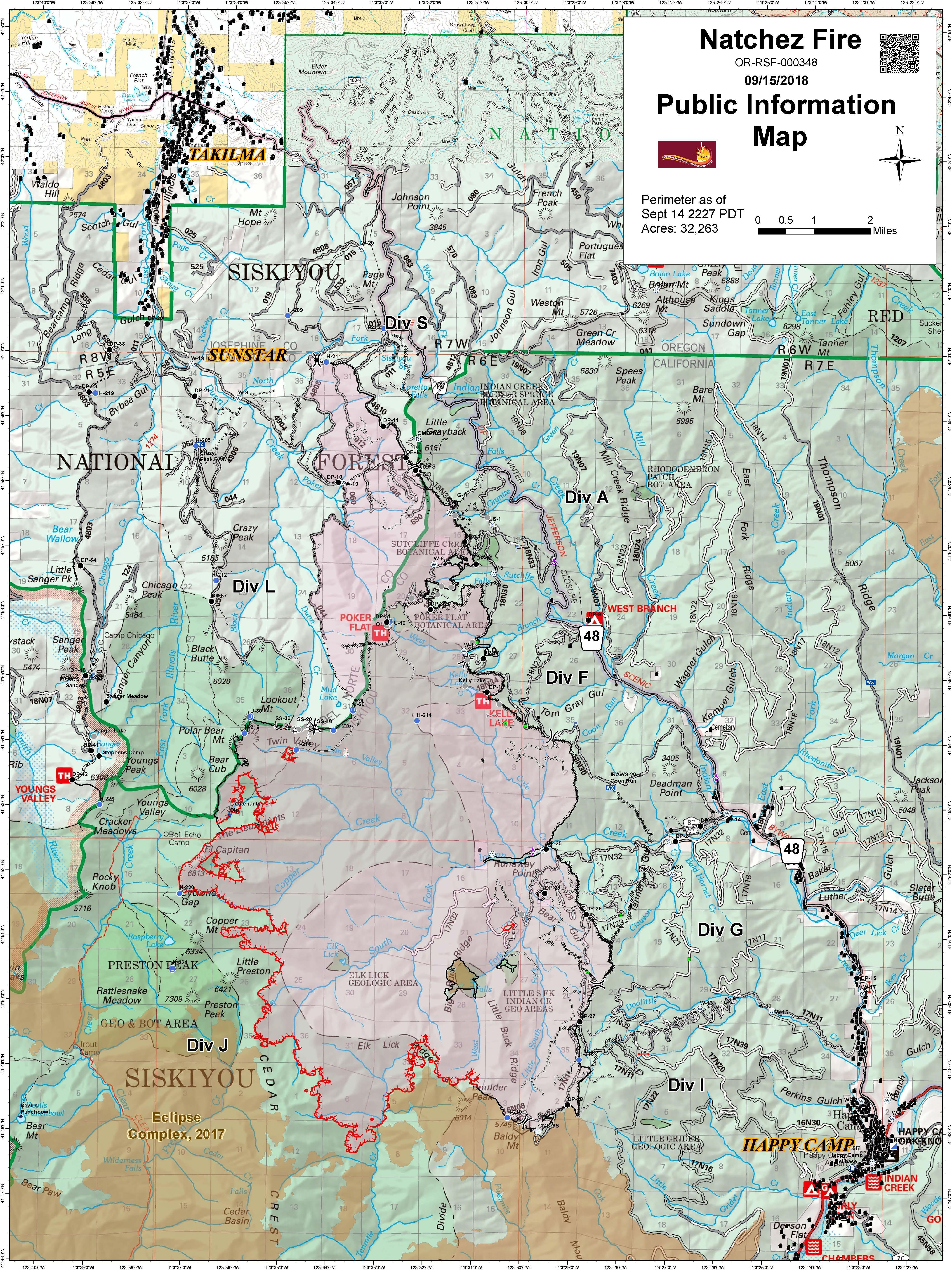
InciwebNatchez Fire Map
This Oregon fire falls under the jurisdiction of the Oregon Department of Forestry Fire, but is also listed on the CAL FIRE map. It’s 33,304 acres and 84 percent contained as of September 19, according to Inciweb. It was caused by lightning. It’s located 15 miles southeast of Cave Junction, Oregon, located on the Oregon/California border between Happy Camp, California and Cave Junction, Oregon.
On September 19, Inciweb still reported the following regarding evacuation notifications and fire closures:
“Evacuation Warning notices are in place for three private in-holdings northwest of Happy Camp. Changes in these evacuation notices can be obtained directly from the Siskiyou County Sheriff’s Office Facebook page at https://www.facebook.com/SiskiyouCountySheriff/. The community of Sunstar remains in a Level 1 evacuation “Ready” status. Changes in these notifications can be obtained directly from the Del Norte County Sheriff’s Office Facebook page at https://www.facebook.com/DelNorteCountySheriffDepartment/.”
“Closure Orders: Two Closure Orders are in effect for the national forest roads, trails, and lands near the Natchez Fire area. Both Closure Orders can be found on Inciweb at:https://inciweb.nwcg.gov/incident/closures/5948/
- Closure Order No. 18-05-012 is in effect on the Happy Camp/Oak Knoll RD, Klamath NF.
- Closure Order No. 06-10-22-18-61 is in effect on the Wild Rivers RD, Rogue River – Siskiyou NF.”
Ranch Fire (Mendocino Complex Fire) *
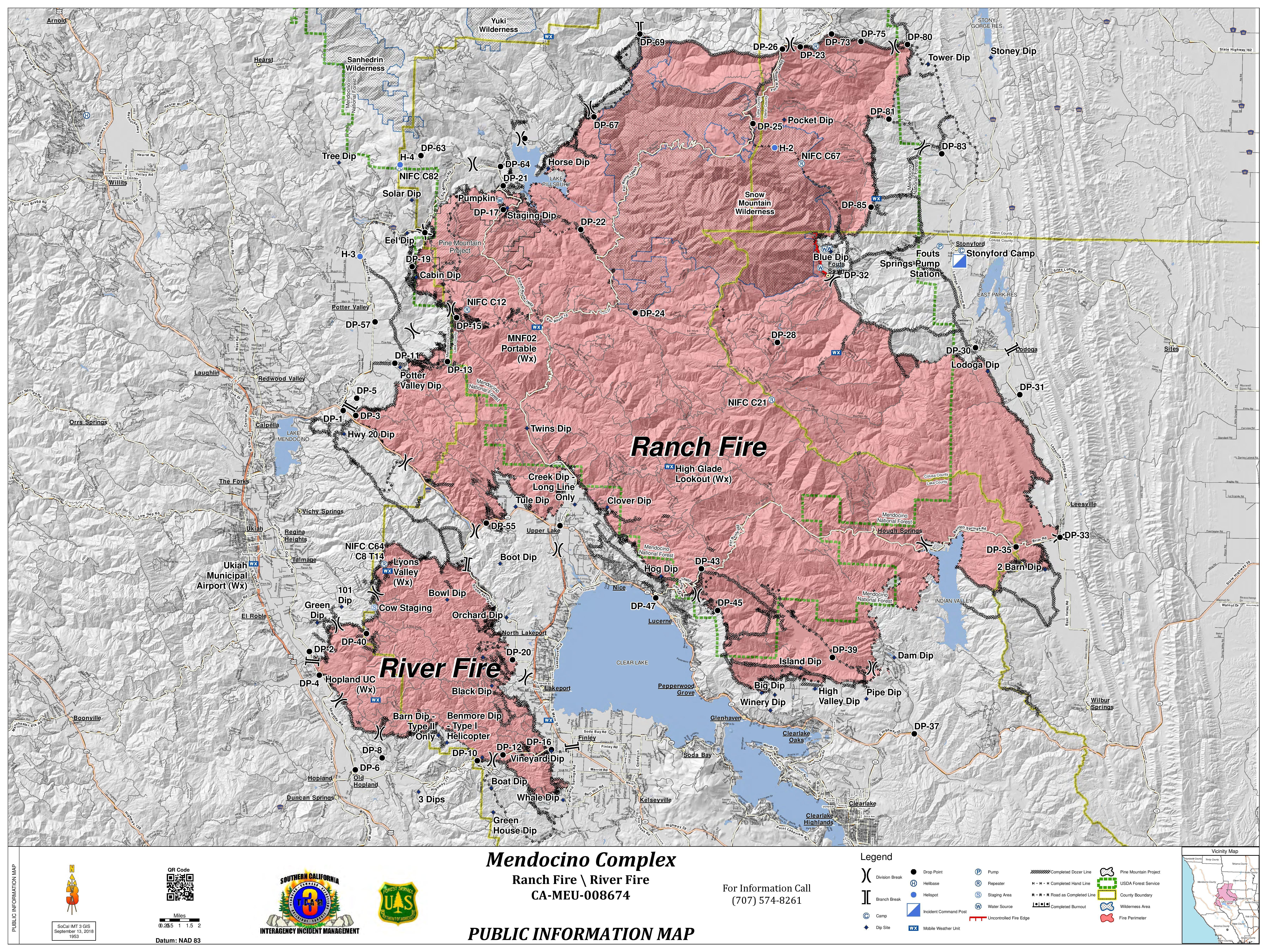
InciwebMendocino Fire Map
This fire was the largest in California’s history at one point, but now it is almost completely contained. It’s off Highway 20 near Potter Valley, northeast of Ukiah in Mendocino/Lake/Colusa Counties. It’s now 459,123 acres and 100 percent contained as of September 19. It was comprised of the River and Ranch fire. The last two percent of the Ranch fire was in steep, rocky terrain.
The cause of this fire is still under investigation.
Here are the most recent closure updates from Inciweb as of September 19: “The Ranch Fire area is closed as described in Forest Order 08-18-15. The purpose of the closure is to provide for public safety and for the firefighters who are engaged in repair efforts within the Ranch Fire closure area. The closure area applies to all public use, including hunting, the use of firearms and off-highway vehicles. The northern half of the forest is open for outdoor activities. The B-Zone deer hunting season opened on Saturday and continues until Sunday 10/21/18. Forest visitors need to exercise extreme caution near the fire closure since heavy equipment and firefighting vehicles are utilizing area roads. Visitors can contact the ranger station nearest their destination for current information.”
For updated details, call 707-574-8261 in Mendocino County.
Soboba Fire
According to CAL FIRE’s map listing: “CAL FIRE is assisting the Soboba Fire Department with a fire off Soboba Rd. San Jacinto, northeast of San Jacinto City, Soboba (Riverside County).” It’s listed as active on CAL FIRE’s map, but more recent reports indicate that it was fully contained a few days ago.
#SobobaFire Indian Creek Road X Soboba Road northeast of San Jacinto City #RiversideCounty. The fire is 100% contained at approximately 25 acres.
Valley Fire *
The Valley fire is 1,350 acres and 82 percent contained as of September 10. It’s at the Valley of the Falls Dr. and Service Road 1S08. According to Inciweb, minimal to no growth is expected and very little fire spread is expected. However, hot and dry conditions have helped the fire stay active. Inciweb isn’t actively updating this every day. The cause of the fire is under investigation.
READ NEXT: Forrest Gordon Clark accused of starting a California fire