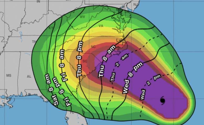
National Weather Service Though Hurricane Florence was downgraded to a category 2 hurricane, it's still caused storm surges up to 10 feet in some areas, with the worst of the flooding still expected to come.
Hurricane Florence hasn’t technically made landfall yet, but the Carolina coastline is already beginning to feel its impact.
The Outer Banks appear to be experiencing severe flooding already, as is evidenced by the video below, which captures the flooding taking place on a road in Avon, North Carolina:
Residents of the Outer Banks area have already been given mandatory evacuation orders, though some residents have confirmed to NBC News that they still intend to stay.
North Carolina’s governor, Roy Cooper, was the one who instituted a “first-of-it’s-kind” mandatory evacuation order for the Outer Banks, which are a series of islands of the coast of North Carolina.
For now, the National Weather Service has several weather warnings in effect for the Outer Banks, including a hazardous weather outlook, a hurricane warning, a flash flood watch, a beach hazards statement, and even a tornado watch for the next few days.
The latest predictions for Florence in the Outer Banks area reflect a likelihood of residents seeing upwards of 90 MPH winds, “extreme” storm surges with “devastating impacts,” and not too much rain, though that could change.
There’s also a “moderate” tornado threat for the area of the Outer Banks, for now.
Accuweather reports that residents of the Carolina coastline should expect to be “bombarded” with rain and heavy wind from Thursday to Saturday. Though NWS estimates upwards of 20 inches of rainfall along the coastline, Accuweather is estimating closer to 40 inches, which could lead to catastrophic levels of flooding from the coastline inland.
NWS confirms that “major to extreme flooding” is likely across central and eastern North Carolina, as Hurricane Florence threatens to pound the state for a full 24 hours.
Weather.com notes that the runoff from this rain will accumulate for several days, and will eventually enter the riverways of the Carolinas and potentially cause swelling of these rivers for multiple months.