NWS When will Hurricane Florence arrive in Jacksonville NC?
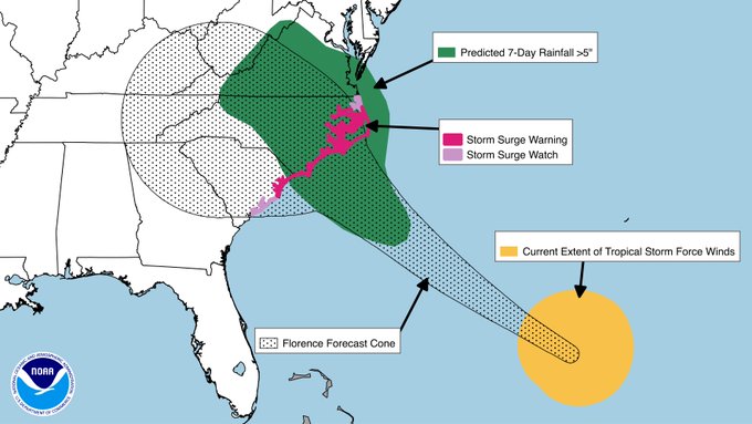
With Hurricane Florence veering toward the North Carolina coast, folks in Jacksonville, NC are wondering when they should expect the storm’s arrival. There is a hurricane warning and storm surge warning in effect for Jacksonville, Richlands, and North Topsail Beach.
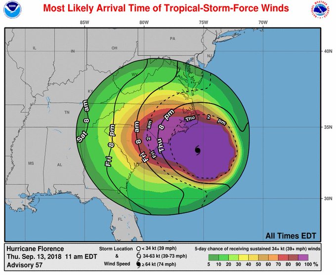
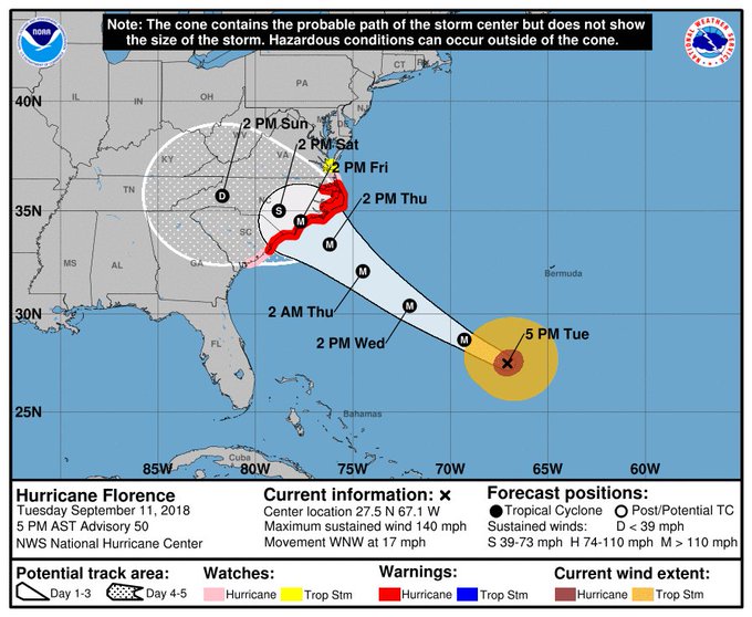
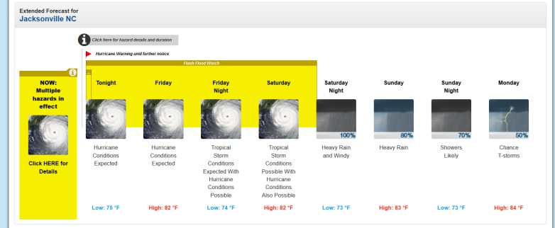
Hurricane Florence is expected to produce hurricane conditions for Jacksonville NC starting the evening of September 13, 2018 and continuing on September 14, 2018. Here is the forecast as of the evening of September 13, 2018:
This is how the forecast looked the day before, on September 12, if you want to compare.

Jacksonville, NC forecast
This was the hazardous weather outlook as of September 13, 2018:
“Hazardous Weather Outlook
National Weather Service Newport/Morehead City NC
527 PM EDT Thu Sep 13 2018
NCZ095-098-103-104-142130-
Carteret-Onslow-Outer Banks Dare-Outer Banks Hyde-
527 PM EDT Thu Sep 13 2018
…FLASH FLOOD WATCH IN EFFECT THROUGH SATURDAY EVENING…
…TORNADO WATCH 371 IN EFFECT UNTIL 9 PM EDT THIS EVENING…
…BEACH HAZARDS STATEMENT IN EFFECT THROUGH FRIDAY EVENING…
…HURRICANE WARNING IN EFFECT…
…STORM SURGE WARNING IN EFFECT…
This Hazardous Weather Outlook is for eastern North Carolina.
.DAY ONE…Tonight.
Please listen to NOAA Weather Radio or go to weather.gov on the
Internet for more information about the following hazards.
Beach Hazards Statement.
Tornado Watch.
Flash Flood Watch.
Hurricane Warning.
Storm Surge Warning.
.DAYS TWO THROUGH SEVEN…Friday through Wednesday.
Please listen to NOAA Weather Radio or go to weather.gov on the
Internet for more information about the following hazards.
Beach Hazards Statement.
Flash Flood Watch.
Hurricane Warning.
Storm Surge Warning.”
A state of emergency has been declared for Onslow County, which holds Jacksonville. Onslow officials said in a press release, “Hurricane Florence has recently upgraded from a Category 3 to a Category 4 hurricane and is projected to make landfall by Thursday night or early Friday morning. Onslow County Board of Commissioners has decided that due to the severe nature of the storm they are declaring a State of Emergency, and encouraging all Onslow County residents to evacuate and seek shelter west of Greensboro. In a meeting with Onslow County partners, government officials also decided that they would activate emergency shelters within the county. These shelters will act as a last resort shelter for residents who cannot evacuate the county.”
The Jacksonville website said that, as of early on September 12, 2018, there were voluntary evacuations for Jacksonville. “The Mayor of Jacksonville has announced a voluntary evacuation of the City and strongly urges residents and visitors to seek safe shelter in a community outside of the area. Hurricane Florence is predicted to be a significant storm with wind speeds of 140 mph and record setting rainfall. Storm surge is expected to be higher than ever experienced in Jacksonville,” the release said. “For those who remain in Jacksonville, a curfew will be issued so that emergency personnel can safely maneuver. Sightseeing after the storm is strongly discouraged. Those who stay should be prepared for a 3 to 4 day event. To prepare, you should:
- have a supply of non-perishable food items and water
- secure valuable documents in a waterproof container
- expect to be without electricity for weeks
- secure windows and outdoor furniture
City operations for non-essential services will close at noon on Wednesday, September 12, 2018.”
Onslow County reported, “Onslow County Government has officially declared a mandatory evacuation for all residents in the unincorporated areas of Onslow County.”
The voluntary nature of the evacuations could always change. You can check the city website here for updates.
You can see the National Weather Service page for Jacksonville, NC here.
See the main Hurricane Florence page for NWS here. The NWS Newport/Morehead office handles weather forecasts for Jacksonville, NC.
See updated spaghetti model sites here.
Get an hourly forecast for Jacksonville here, and read about Hurricane Florence evacuation zones here.
The NWS office serving Jacksonville released this lengthy hazardous weather outlook as of the evening of September 12, 2018:
“* WIND
– LATEST LOCAL FORECAST: Equivalent Cat 1 Hurricane force wind
– Peak Wind Forecast: 55-75 mph with gusts to 90 mph
– Window for Tropical Storm force winds: Thursday morning
until early Sunday morning
– Window for Hurricane force winds: Thursday evening until
Friday evening
– POTENTIAL THREAT TO LIFE AND PROPERTY: Potential for wind
greater than 110 mph
– The wind threat has remained nearly steady from the
previous assessment.
– PLAN: Plan for extreme wind of equivalent CAT 3 hurricane
force or higher due to possible forecast changes in track,
size, or intensity.
– PREPARE: Remaining efforts to protect life and property
should be urgently completed. Prepare for catastrophic wind
damage.
– ACT: Move to safe shelter before the wind becomes hazardous.
– POTENTIAL IMPACTS: Devastating to Catastrophic
– Structural damage to sturdy buildings, some with complete
roof and wall failures. Complete destruction of mobile
homes. Damage greatly accentuated by large airborne
projectiles. Locations may be uninhabitable for weeks or
months.
– Numerous large trees snapped or uprooted along with fences
and roadway signs blown over.
– Many roads impassable from large debris, and more within
urban or heavily wooded places. Many bridges, causeways,
and access routes impassable.
– Widespread power and communications outages.
* STORM SURGE
– LATEST LOCAL FORECAST: Life-threatening and historic storm
surge possible
– Peak Storm Surge Inundation: The potential for 9-13 feet
above ground somewhere within surge prone areas
– Window of concern: through early Sunday afternoon
– POTENTIAL THREAT TO LIFE AND PROPERTY: Potential for storm
surge flooding greater than 9 feet above ground
– The storm surge threat has remained nearly steady from the
previous assessment.
– PLAN: Shelter against extreme life-threatening storm surge
flooding greater than 9 feet above ground.
– PREPARE: All ordered evacuations should be complete.
Evacuees should be in shelters well away from storm surge
flooding.
– ACT: Remain sheltered in a safe location. Do not venture
outside. Move to upper floors to escape rising water if
necessary.
– POTENTIAL IMPACTS: Unfolding
– Potential impacts from the main surge event are unfolding.
* FLOODING RAIN
– LATEST LOCAL FORECAST: Flash Flood Watch is in effect
– Peak Rainfall Amounts: Additional More than two feet
– POTENTIAL THREAT TO LIFE AND PROPERTY: Potential for extreme
flooding rain
– The flooding rain threat has increased from the previous
assessment.
– PLAN: Emergency plans should include the potential for
extreme flooding from heavy rain. Evacuations and rescues
are likely.
– PREPARE: Urgently consider protective actions from extreme
and widespread rainfall flooding.
– ACT: Heed any flood watches and warnings. Failure to take
action will likely result in serious injury or loss of life.
– POTENTIAL IMPACTS: Devastating to Catastrophic
– Extreme rainfall flooding may prompt numerous evacuations
and rescues.
– Rivers and tributaries may overwhelmingly overflow their
banks in many places with deep moving water. Small streams,
creeks, canals, and ditches may become raging rivers. Flood
control systems and barriers may become stressed.
– Flood waters can enter numerous structures within multiple
communities, some structures becoming uninhabitable or
washed away. Numerous places where flood waters may cover
escape routes. Streets and parking lots become rivers of
raging water with underpasses submerged. Driving conditions
become very dangerous. Numerous road and bridge closures
with some weakened or washed out.
* TORNADO
– LATEST LOCAL FORECAST:
– Situation is somewhat favorable for tornadoes
– POTENTIAL THREAT TO LIFE AND PROPERTY: Potential for a few
tornadoes
– The tornado threat has remained nearly steady from the
previous assessment.
– PLAN: Emergency plans should include the potential for a
few tornadoes.
– PREPARE: If your shelter is particularly vulnerable to
tornadoes, prepare to relocate to safe shelter before
hazardous weather arrives.
– ACT: If a tornado warning is issued, be ready to shelter
quickly.
– POTENTIAL IMPACTS: Limited
– The occurrence of isolated tornadoes can hinder the
execution of emergency plans during tropical events.
– A few places may experience tornado damage, along with
power and communications disruptions.
– Locations could realize roofs peeled off buildings,
chimneys toppled, mobile homes pushed off foundations or
overturned, large tree tops and branches snapped off,
shallow-rooted trees knocked over, moving vehicles blown
off roads, and small boats pulled from moorings.”
Jacksonville, North Carolina Extended Weather Forecast
The National Weather Service had this forecast for Jacksonville as of September 13, 2018:
“Tonight (September 13, 2018)
Hurricane conditions expected. Showers and possibly a thunderstorm. Some of the storms could produce heavy rainfall. Low around 75. Chance of precipitation is 100%. New rainfall amounts in excess of 4 inches possible.
Friday
Hurricane conditions expected. Showers and possibly a thunderstorm. Some of the storms could produce heavy rainfall. High near 82. Chance of precipitation is 100%. New rainfall amounts in excess of 4 inches possible.
Friday Night
Tropical storm conditions expected, with hurricane conditions possible. Showers and possibly a thunderstorm. Some of the storms could produce heavy rainfall. Low around 74. Chance of precipitation is 100%. New rainfall amounts in excess of 4 inches possible.
Saturday
Tropical storm conditions possible, with hurricane conditions also possible. Showers and possibly a thunderstorm. Some of the storms could produce heavy rainfall. High near 82. Chance of precipitation is 100%. New rainfall amounts between 2 and 3 inches possible.
Saturday Night
Showers and possibly a thunderstorm. Some of the storms could produce heavy rainfall. Low around 73. Windy, with an east wind 17 to 26 mph, with gusts as high as 38 mph. Chance of precipitation is 100%. New rainfall amounts between 1 and 2 inches possible.
Sunday
Showers and possibly a thunderstorm. Some of the storms could produce heavy rainfall. High near 83. Chance of precipitation is 80%. New rainfall amounts between three quarters and one inch possible.
Sunday Night
Showers likely and possibly a thunderstorm before 9pm, then a chance of showers. Mostly cloudy, with a low around 73. Chance of precipitation is 70%.
Monday
A chance of showers, with thunderstorms also possible after 9am. Mostly cloudy, with a high near 84. Chance of precipitation is 50%.
Monday Night
A chance of showers and thunderstorms. Mostly cloudy, with a low around 72. Chance of precipitation is 50%.
Tuesday
A chance of showers, with thunderstorms also possible after 9am. Mostly cloudy, with a high near 85. Chance of precipitation is 50%.
Tuesday Night
A chance of showers and thunderstorms. Mostly cloudy, with a low around 73. Chance of precipitation is 50%.
Wednesday
A chance of showers and thunderstorms. Partly sunny, with a high near 87. Chance of precipitation is 40%.
Wednesday Night
A chance of showers and thunderstorms. Partly cloudy, with a low around 72. Chance of precipitation is 40%.
Thursday
A chance of showers and thunderstorms. Mostly sunny, with a high near 85. Chance of precipitation is 40%.”
