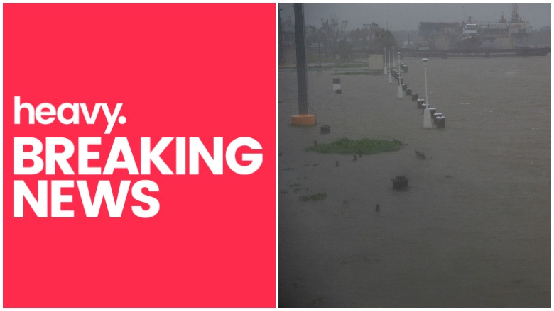
Getty Benches and walkways are flooded by water along the Berwick River in Morgan City, Louisiana ahead of Tropical Storm Barry Saturday, July 13,2019. - Tropical Storm Barry is the first tropical storm system of 2019 to make landfall in the United States the storm is around 10 miles offshore from Louisiana. Barry will dump up to two feet of rain along with strong winds and storm-surge flooding according to weather reports.
The National Weather Service said Saturday morning that Tropical Storm Barry was now Hurricane Barry, a category 1 storm, heading toward land. But when it arrived early Saturday afternoon, near Intracoastal City, it was quickly downgraded to Tropical Storm status again, with 65 MPH sustained winds and expected 85 MPH gusts. Barry is expected to bring far more rain than wind. Forecasters say two or more feet of rain is expected and rain will fall where flooding has previously been an issue, the NWS says. Inland flooding was a big concern.
Saturday the National Hurricane Center said it expects storm surge inundation along the coast of southern and Southeastern Louisiana, portions of Lake Pontchartrain, and portions of coastal Mississippi where a storm surge warning is in effect. Water levels have already begun to rise in these areas, the NHC said in its 10 a.m. forecast update, “with peak inundation expected to occur later today. The highest storm surge inundation is expected between Intracoastal City and Shell Beach. And flooding reports were coming in from several areas.
Now a tropical storm, #Barry continues to cause high waves on Lake Pontchartrain and flooding along the lakefront. These Mandeville residents don’t seem to mind though. #TropicalStormBarry #TrackingBarry #NOLAwx #LAwx #flooding @WGNOtv

As of Friday evening, some four million people are under a tropical alert. The Weather Channel reported “disastrous” flooding is possible, per the National Hurricane Center’s alerts. New Orleans called for voluntary evacuations for people who live in areas outside the levees, asked residents to be indoors by 8 p.m., and shelter in place as the city suspended public transit.
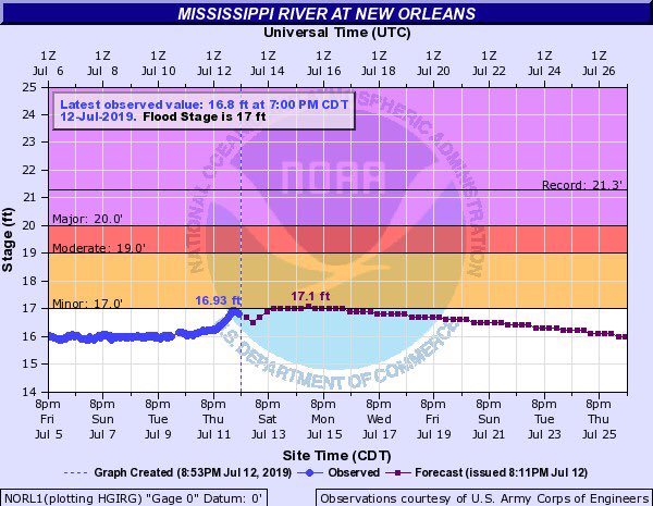
The Mississippi River is expected to crest at 17 feet in New Orleans on Saturday, though “levees protect up to 20 feet.”
A Storm Surge Warning continues for Intracoastal City to Biloxi, and Lake Pontchartrain. There is a danger of life-threatening inundation from rising water moving inland from the coastline during the next 36 hours in indicated locations. #Barry latest: t.co/hViXA0kC3s

Saturday morning, the US Army Corps of Engineers said, “Storm Surge Warning continues for Intracoastal City to Biloxi, and Lake Pontchartrain. Life-threatening inundation from rising water moving inland during the next 36 hours in indicated locations.”
The Mississippi River is now forecast to crest at about 17 feet, 2 feet lower than predicted. Levees protect up to 20 feet. Storm surge has passed, meaning risk of overtopping is minimal. #NOLAready
Still, the flood gates along the Big Mud were closed.
At its 7 p.m. update, the NWS said Barry will bring a storm surge of up to six feet and 10 to 20 inches of rain.
There’s widespread concern about inland flooding and the surge of water that is the most serious. Storm surge is produced by water being pushed toward the shore by the force of the winds moving cyclonically around the storm. The impact on surge of the low pressure associated with intense storms is minimal in comparison to the water being forced toward the shore by the wind.
Here comes the storm surge! #Barry #TropicalStormBarry
The surge is caused by slow-moving Barry churning over the hot-water Gulf, where temperatures range in the high 80s and low 90s.
VIDEO: View of LA 1 from the South Lafourche Levee. Video provided by Golden Meadow Police Chief Reggie Pitre. #TropicalStormBarry
Here’s what you need to know:
Flooding From Rain & Storm Surge is the Greatest Threat to Life & Property in a Hurricane, NOAA Says
🚨STORM SURGE ALERT🚨 Check out what our field crews are seeing in #Louisiana. #StormSurge is already making its way into portions of the gulf coast. We’ll continue to have updates on-air and online.
#TropicalStormBarry Updates – t.co/VzCYepaAbA
According to the National Oceanic and Atmospheric Administration, along the coast, storm surge and flooding is often the greatest threat to life and property from a hurricane.
Aerial footage of storm surge inundation in the Reggio community in coastal Louisiana. Latest update on Tropical Storm Barry: t.co/SWDzD2DKeu
NOAA says that “large death tolls have resulted from the rise of the ocean associated with many of the major hurricanes that have made landfall” with Hurricane Katrina in 2005 a prime example “of the damage and devastation that can be caused by surge” and flooding.
Residents for Tropical Storm Barry told to Shelter in place by 8pm, stay off the streets & out of water.
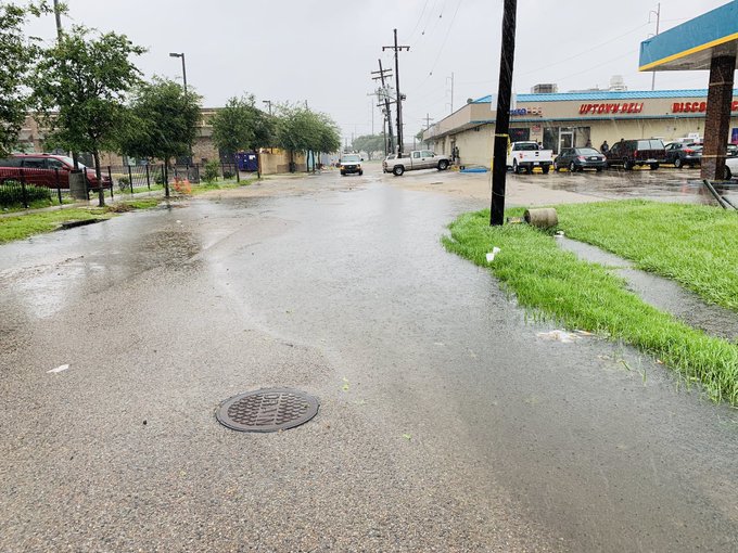
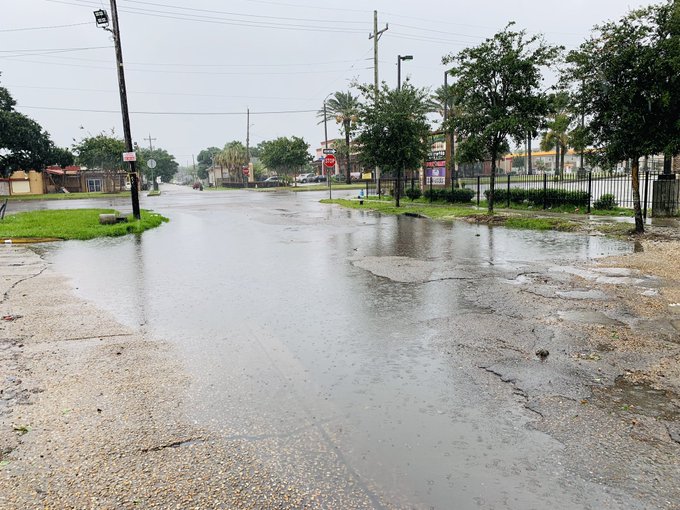
Storm surge has started making many roads impassable.
Stay Safe Everyone!🙏
For Emergency Alerts Text BARRY to 888-777
#Louisiana
#NewOrleans
#Barry
More than 1,500 people died during Katrina and, NOAA says, “many of those deaths occurred directly, or indirectly, as a result of storm surge” and subsequent flooding.
I know #Barry is late to the party, but 1 of the biggest concerns in Baton Rouge will continue to be Comite River (which @mikedunlapphoto & I just visited). It’s forecast to crest early next week above 34 ft, which could mean big time flooding for Central, Greenwell Springs, etc
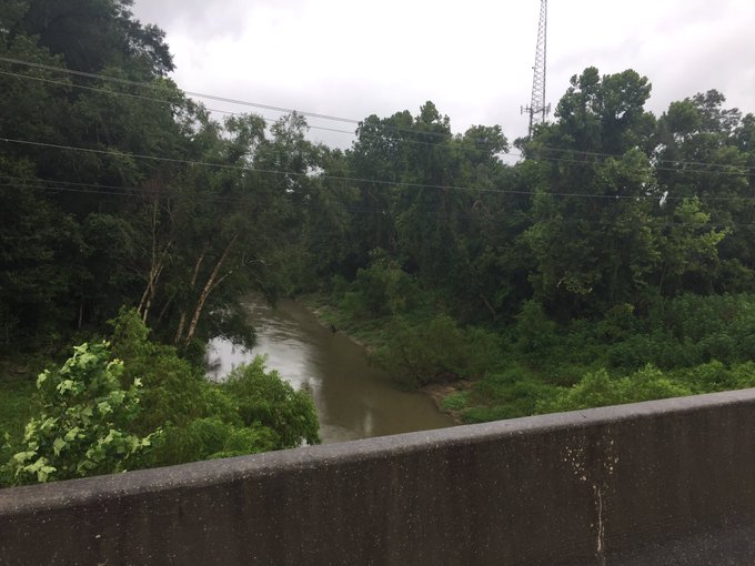
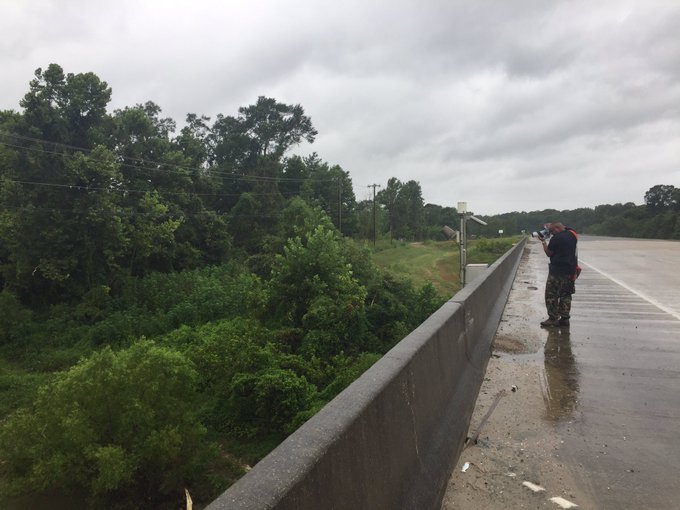

“I know #Barry is late to the party, but 1 of the biggest concerns in Baton Rouge will continue to be Comite River (which @mikedunlapphoto & I just visited). It’s forecast to crest early next week above 34 ft, which could mean big time flooding for Central, Greenwell Springs, etc.”
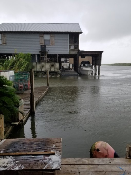
“Storm surge in Mandeville has advanced visibly in the few minutes I’ve been here.”
Even as #Barry pulls away from SE Louisiana into early next week, big flooding concerns will linger. Some crests will rival historic crests from 2016. @wdsu #lawx #Louisiana
“Some crests will rival historic crests from 2016.”
Some wild video of two dogs’ reaction to flooding and what comes with it sometimes, like a displaced baby gator.
We’ve told you about the possibility of interaction with animals during a flood event. Watch what happened to a family in Livingston Parish! (No animals were harmed while this video was recorded) #hurricanebarry #lawx
“We’ve told you about the possibility of interaction with animals during a flood event. Watch what happened to a family in Livingston Parish! (No animals were harmed while this video was recorded)”
But seriously, flooding is a major concern.
Levee overtopping at Myrtle Grove, LA in Plaquemines Parish from #Hurricane #Barry. Numerous spots are being overtopped and water is running down towards HWY 23 in Plaquemines Parish. State Police are prepared to close the HWY when water reaches it. #storm #surge #flooding
And appears to be widespread.
#BREAKING: Major storm surge already in Mandeville, #Louisiana as hurricane #Barry made landfall minutes ago. Barry is now back to being a tropical storm, but flooding will worsen and heaviest rain yet to come
Developing…
Friday Evening, Many Hours Before Landfall, Waters Were Already Rising & Storm Surge Evident & By Late Night, Conditions Were Worsening & Saturday Morning, Waters Were Rising
Is anyone remember that saying “good Lord willing and the Creek don’t rise”. well the Creek has risen. God-bless all those in South East and Gulf Louisiana God-bless us all. I love my family and my friends. 10 to 15″ of rain still to come and the storm surge will hit tomorrow.
At just after 6 p.m. Friday, many hours before the storm was expected to make landfall, the water it’s bringing with it was already being felt.
“Is anyone remember that saying “good Lord willing and the Creek don’t rise”. well the Creek has risen. God-bless all those in South East and Gulf Louisiana God-bless us all. I love my family and my friends. 10 to 15″ of rain still to come and the storm surge will hit tomorrow.”
Also just after 6, this tweet about lake flooding, well in advance of the storm.
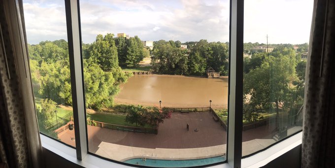
“FRIDAY 6:24pm — I’ll be tracking #TropicalStormBarry storm surge levels from my hotel window in Lafayette, Louisiana. Note the water levels!”
FRIDAY 6:24pm — I’ll be tracking #TropicalStormBarry storm surge levels from my hotel window in Lafayette, Louisiana.
Note the water levels
As NOAA has pointed out, it’s the storm surge and subsequent flooding from surge and rains, that is perhaps the greatest threat to life and property in a hurricane.
This man decided to go swimming in the Mississippi River as the storm surge gets worse in New Orleans. Read the latest on Tropical Storm Barry: t.co/iSfrbFy2Ua
Not the best idea.
By 11 p.m., conditions were worsening.
“Situation is worsening on the southeast coast of Louisiana, storm surge quickly worsening as hurricane #Barry nears.”
VIDEO -Tropical Storm Barry approaches the Louisiana coast storm surge intensified rapidly in Golden Meadows, LA.This forced the closure of Hwy 1 which runs to Grand Isle cutting off everyone below Golden Meadow who chose to ignore the Mandatory Evacuation. @LiveStormsMedia #ARWX
It was reported that at around 10 p.m., “storm surge intensified rapidly in Golden Meadows, LA.This forced the closure of Hwy 1 which runs to Grand Isle cutting off everyone below Golden Meadow who chose to ignore the Mandatory Evacuation.”
In some locations, particularly extreme south Louisiana, evacuations were mandatory, Plaquemines Parish being among them. .
@Christi_Paul #Barry update from #Mandeville La. 5 ft or storm surge on Lake Pontchartrain @cnnbrk @AllisonCNN @NewDay t.co/eECuA4jxMo

As the sun is about to rise, a view Saturday morning shows the steady and relentless surge.
The US Coast Guard Secured the Gulf Coast as Hurricane Barry Moved Inland & Had Begun Rescues
The Coast Guard says its Eighth Coast Guard District staff are “pre-staging assets in safe and nearby locations to prepare to respond after Tropical Storm Barry makes landfall.”
The CG closed the port of New Orleans.
The road to Grand Isle, LA is about to be cutoff #lawx #barry @MyRadarWX
Aircraft at stations in Houston, New Orleans and Mobile, Alabama are in place, its Shallow Water Response teams have deployed and pre-staged in Covington, Louisiana.
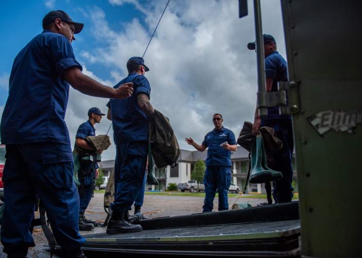
US Coast GuardA shallow water response team from Coast Guard Marine Safety Unit Paducah prepares flood response gear in Covington, Louisiana, July 12, 2019. The team traveled from Paducah, Kentucky, to respond to Tropical Storm Barry. (U.S. Coast Guard photo by Petty Officer 2nd Class Travis Magee/Released)
Another three teams have deployed and pre-staged in Shreveport. Its New Orleans-based mobile response teams are getting ready in Slidell, Louisiana and the Coast Guard has crews from Tactical Law Enforcement Team South and Marine Safety and Security Team Kings Bay on standby in Mobile. A Coast Guard Family Support Team has been established in Slidell to “facilitate lodging and needs of evacuated dependents.”
Numerous roads in the Reggio area are now covered with high water from storm surge inundation. Canals are also backing up and causing flooding of roadways and property. Campers and homes in the area are being threatened. Full story on Tropical Storm Barry: t.co/SWDzD2DKeu
The Coast Guard says that given “hurricanes and tropical storms can be deadly’ its ability to do rescues “can be diminished or non-existent at the height of the storm,” so it advises people to “be prepared, stay informed, and heed storm warnings.”
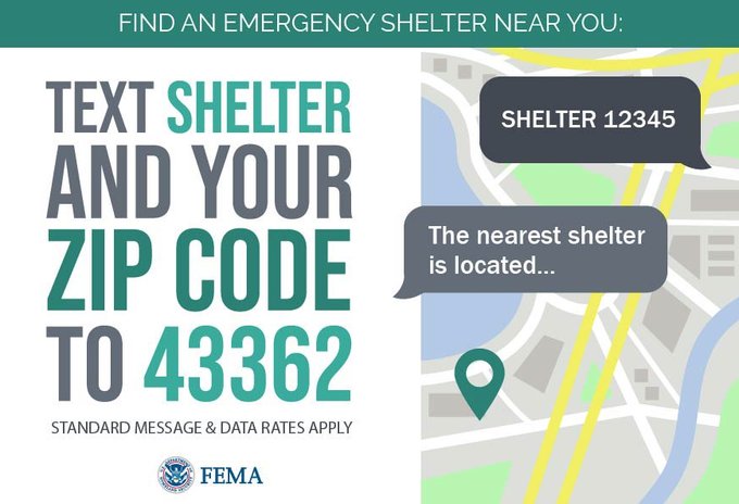
⚠️Find the nearest @fema emergency shelter to you by texting your ZIPCODE to 43362!
More information: follow @Readygov and go to t.co/IAL1s8B0nf
This post will be updated.